 Demo Catalogue powered by geOrchestra
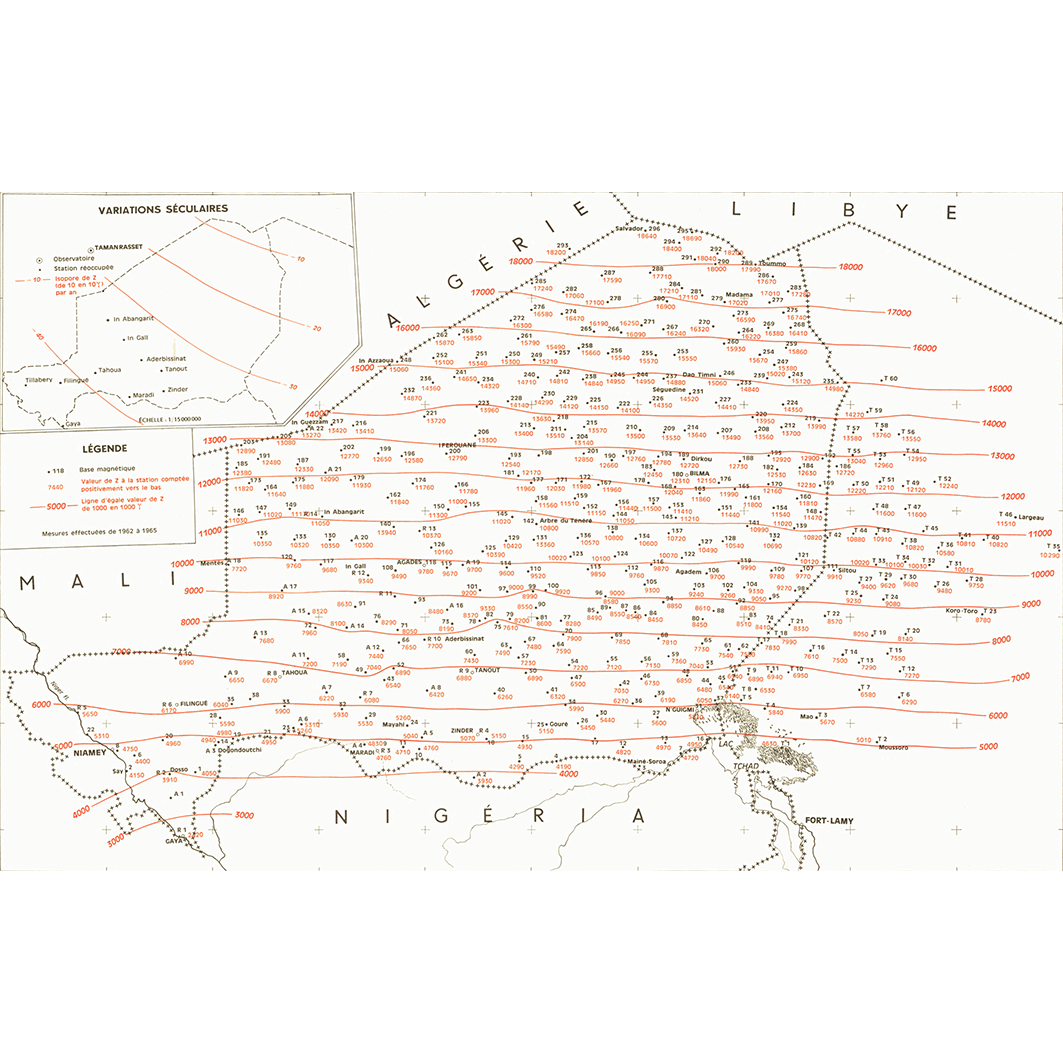
Bases magnétiques du Niger et du Tchad occidental : valeurs ramenées au 1er janvier 1965. Scale of 1:5 000 000. Date of publication: 1967.
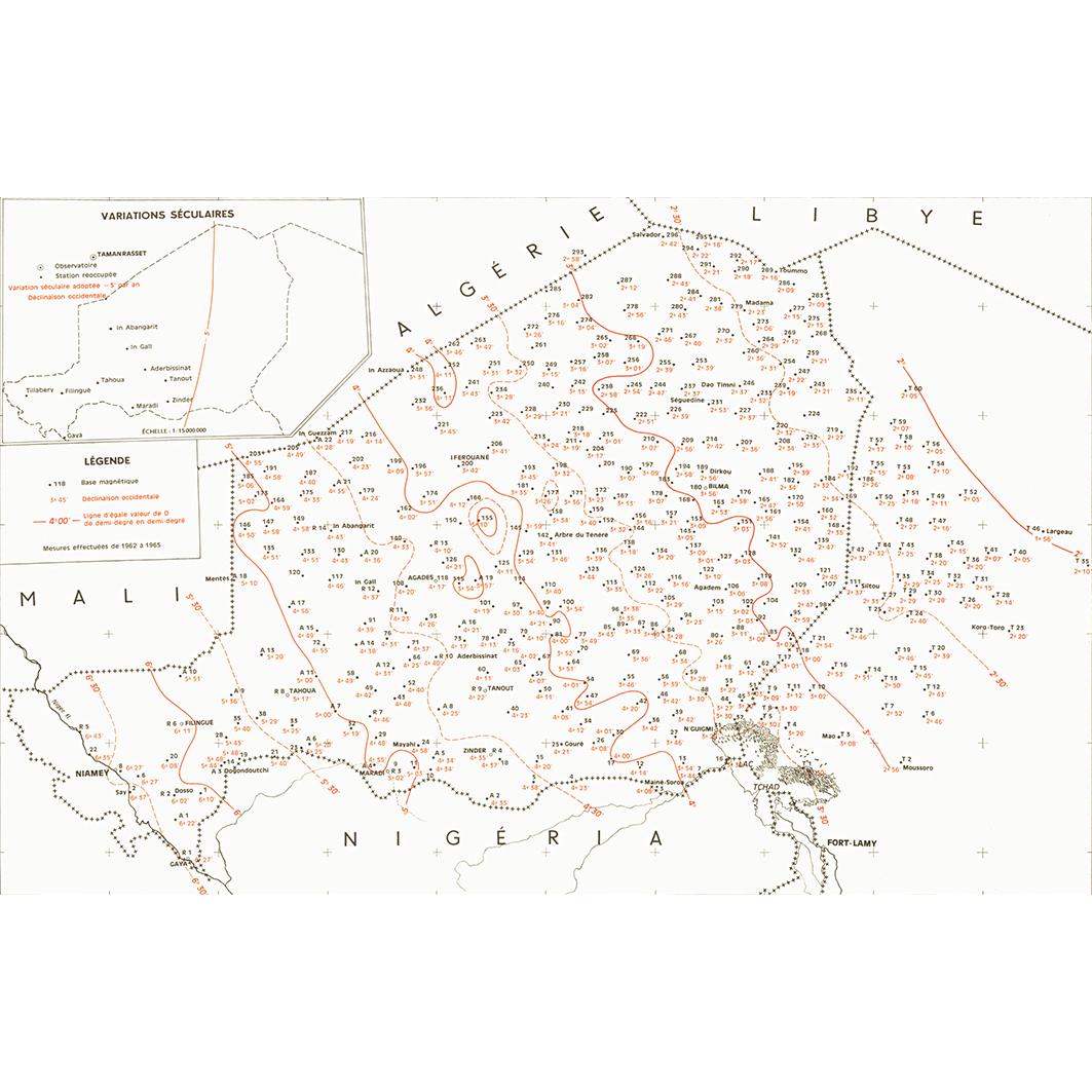
1. Bases magnétiques du Niger et du Tchad occidental : valeurs ramenées au 1er janvier 1965 : D : déclinaison. / Buffard Morel, J. M. (ill.); Scale of 1:5 000 000. Date of publication: 1967. (file: 01652RC_IRD_-AF_GPMA_1967_5000000_IRD_-AF_GPMA_1967_5000000.tif)
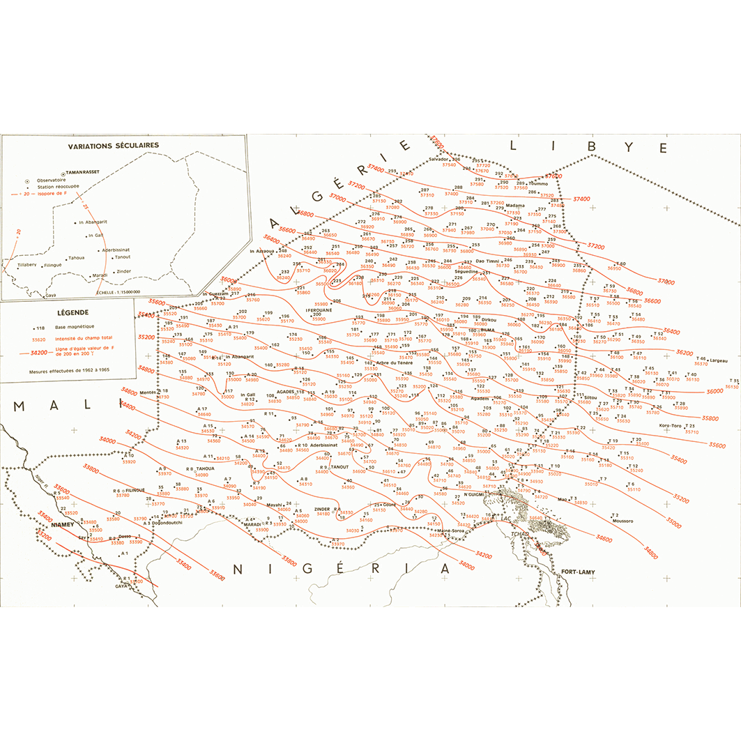
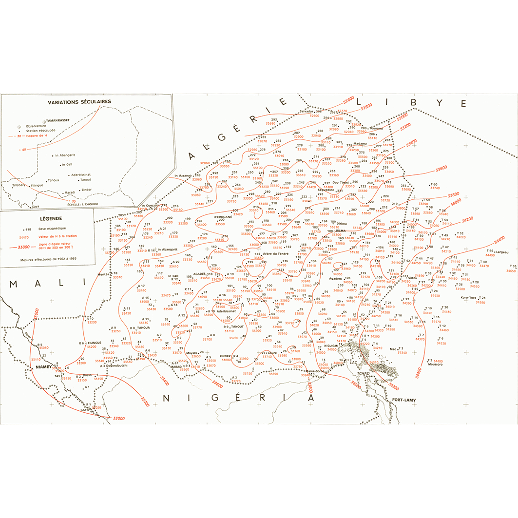
2. Bases magnétiques du Niger et du Tchad occidental : valeurs ramenées au 1er janvier 1965 : F : champ total. / Buffard Morel, J. M. (ill.); Scale of 1:5 000 000. Date of publication: 1967. (file: 01647RC_IRD_-AF_GPMA_1967_5000000_IRD_-AF_GPMA_1967_5000000.tif)
3. Bases magnétiques du Niger et du Tchad occidental : valeurs ramenées au 1er janvier 1965 : H : composante horizontale. / Buffard Morel, J. M. (ill.); Scale of 1:5 000 000. Date of publication: 1967. (file: 01654RC_IRD_-AF_GPMA_1967_5000000_IRD_-AF_GPMA_1967_5000000.tif)
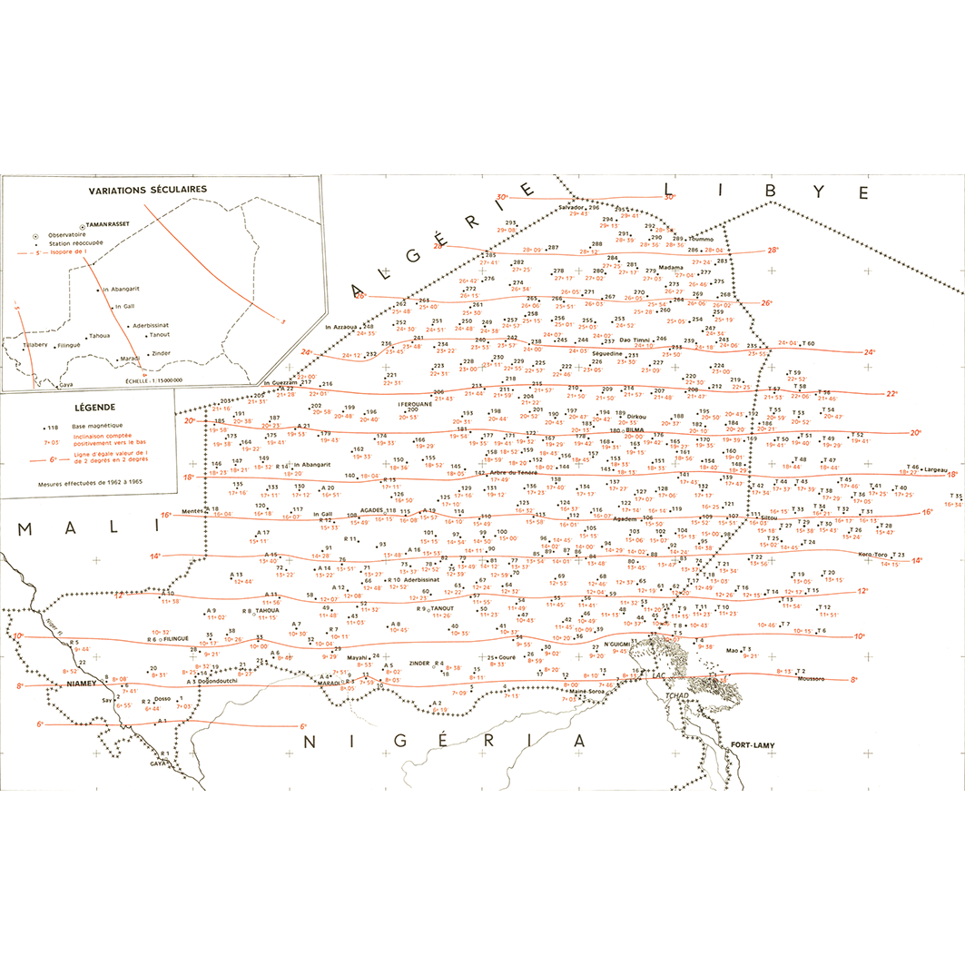
4. Bases magnétiques du Niger et du Tchad occidental : valeurs ramenées au 1er janvier 1965 : I : inclinaison. / Buffard Morel, J. M. (ill.); Scale of 1:5 000 000. Date of publication: 1967. (file: 01653RC_IRD_-AF_GPMA_1967_5000000_IRD_-AF_GPMA_1967_5000000.tif)
5. Bases magnétiques du Niger et du Tchad occidental : valeurs ramenées au 1er janvier 1965 : Z : composante verticale. / Buffard Morel, J. M. (ill.); Scale of 1:5 000 000. Date of publication: 1967. (file: 01655RC_IRD_-AF_GPMA_1967_5000000_IRD_-AF_GPMA_1967_5000000.tif)
Simple
- Date (Publication)
- 1967-01-01
- Citation identifier
- IRD_-AF_GPMA_1967_5000000
- Credit
-
The region Île-de-France, under the project NumeriSud, supported the action to transforme around 2800 maps that are conserved at the Institut de recherche pour le développement (IRD) library in Bondy into a standard coordinate system. The transformation of the images has been done by Global Mapping Resources (South Africa) under the supervision of R. Zaiss (éditeur) 2014.
- Status
- Completed
- Point of contact
-
Organisation name Individual name Electronic mail address Role Institut de recherche pour le développement (IRD)
Production cartographique IRD
Point of contact Buffard Morel, J. M. (ill.)
Author ORSTOM, Office de la recherche scientifique et technique outre-mer, Centre de géophysique
editor
- Maintenance and update frequency
- Not planned
-
Geounits
-
-
Africa
-
Middle Africa
-
Western Africa
-
Chad
-
Niger
-
Nigeria
-
- Theme
-
-
thematic map
-
- Keywords
-
-
project NumeriSud
-
national coverage
-
- Use limitation
-
Licence : CC-BY-NC-SA
- Access constraints
- licence
- Classification
- Unclassified
- Spatial representation type
- Grid
- Denominator
- 5000000
- Language
- Français
- Character set
- UTF8
- Topic category
-
- Geoscientific information
))
- Begin date
- 1967-01-01
- End date
- 1967-12-31
- Supplemental Information
-
Publication(s):
ORSTOM (éditeur) (1967): Réseau de bases magnétiques : 1. Au Niger et au Tchad occidental : mesures effectuées de 1962 à 1965. 2. En Afrique occidentale : mesures effectuées de 1959 à 1962. [M'Bour ?] (SEN) : ORSTOM, Office de la recherche scientifique et technique outre mer, Centre de géophysique.
- Reference system identifier
- EPSG / 4326 / 7.9
- Distribution format
-
Name Version GeoTIFF
1.0
- Distributor contact
-
Organisation name Individual name Electronic mail address Role DataSuds-geo
Publisher
- OnLine resource
-
Protocol Linkage Name OGC:WMS
https://datasuds-geo.ird.fr/geoserver/wms sphaera_ws:01652RC_IRD_-AF_GPMA_1967_5000000_IRD_-AF_GPMA_1967_5000000
WWW:DOWNLOAD:GeoTIFF https://datasuds-geo.ird.fr/geoserver/ows?service=WCS&version=2.0.1&request=GetCoverage&coverageId=01652RC_IRD_-AF_GPMA_1967_5000000_IRD_-AF_GPMA_1967_5000000 WWW:LINK-1.0-http--related
https://www.documentation.ird.fr/hor/fdi:14967 Notice explicative ou autre ouvrage
- OnLine resource
-
Protocol Linkage Name OGC:WMS
https://datasuds-geo.ird.fr/geoserver/wms sphaera_ws:01647RC_IRD_-AF_GPMA_1967_5000000_IRD_-AF_GPMA_1967_5000000
WWW:DOWNLOAD:GeoTIFF https://datasuds-geo.ird.fr/geoserver/ows?service=WCS&version=2.0.1&request=GetCoverage&coverageId=01647RC_IRD_-AF_GPMA_1967_5000000_IRD_-AF_GPMA_1967_5000000 WWW:LINK-1.0-http--related
https://www.documentation.ird.fr/hor/fdi:14967 Notice explicative ou autre ouvrage
- OnLine resource
-
Protocol Linkage Name OGC:WMS
https://datasuds-geo.ird.fr/geoserver/wms sphaera_ws:01654RC_IRD_-AF_GPMA_1967_5000000_IRD_-AF_GPMA_1967_5000000
WWW:DOWNLOAD:GeoTIFF https://datasuds-geo.ird.fr/geoserver/ows?service=WCS&version=2.0.1&request=GetCoverage&coverageId=01654RC_IRD_-AF_GPMA_1967_5000000_IRD_-AF_GPMA_1967_5000000 WWW:LINK-1.0-http--related
https://www.documentation.ird.fr/hor/fdi:14967 Notice explicative ou autre ouvrage
- OnLine resource
-
Protocol Linkage Name OGC:WMS
https://datasuds-geo.ird.fr/geoserver/wms sphaera_ws:01653RC_IRD_-AF_GPMA_1967_5000000_IRD_-AF_GPMA_1967_5000000
WWW:DOWNLOAD:GeoTIFF https://datasuds-geo.ird.fr/geoserver/ows?service=WCS&version=2.0.1&request=GetCoverage&coverageId=01653RC_IRD_-AF_GPMA_1967_5000000_IRD_-AF_GPMA_1967_5000000 WWW:LINK-1.0-http--related
https://www.documentation.ird.fr/hor/fdi:14967 Notice explicative ou autre ouvrage
- OnLine resource
-
Protocol Linkage Name OGC:WMS
https://datasuds-geo.ird.fr/geoserver/wms sphaera_ws:01655RC_IRD_-AF_GPMA_1967_5000000_IRD_-AF_GPMA_1967_5000000
WWW:DOWNLOAD:GeoTIFF https://datasuds-geo.ird.fr/geoserver/ows?service=WCS&version=2.0.1&request=GetCoverage&coverageId=01655RC_IRD_-AF_GPMA_1967_5000000_IRD_-AF_GPMA_1967_5000000 WWW:LINK-1.0-http--related
https://www.documentation.ird.fr/hor/fdi:14967 Notice explicative ou autre ouvrage
- OnLine resource
-
Protocol Linkage Name DOI
https://doi.org/10.23708/fcf7b593-a887-4b55-8892-f090f7251721 Digital Object Identifier (DOI)
- Hierarchy level
- Dataset
- Statement
-
1. Scanning to tif format, 256 colors, 250dpi.
2. Georeferencing and if possible reprojection to WGS84 (Longitude / Latitude).
3. Clipping and mosaicing of map sheets(s).
4. Export ECW format.
5. ECW to GeoTIFF format conversion.
Metadata
- File identifier
- fcf7b593-a887-4b55-8892-f090f7251721 XML
- Metadata language
- English
- Character set
- UTF8
- Hierarchy level
- Dataset
- Hierarchy level name
-
dataset
- Date stamp
- 2024-02-13T19:26:20.380566Z
- Metadata standard name
-
ISO 19115:2003/19139
- Metadata standard version
-
1.0
- Metadata author
-
Organisation name Individual name Electronic mail address Role Institut de recherche pour le développement (IRD)
Service de l'Information Scientifique et Technique (IST) IRD
Point of contact Institut de recherche pour le développement (IRD)
IRD
Resource provider
Overviews
Spatial extent
Provided by
