 Demo Catalogue powered by geOrchestra
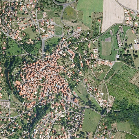
Orthophotographie couleur - Département du Puy de Dôme - PVA été 2009
Le produit Orthophotographie couleur - Département du Puy de Dôme est une orthophotographie numérique en couleurs, rectifiées dans la projection associée au système géodésique RGF93. Résolution : 0,30m / pixel - Précision planimétrique 0,60m / pixel - Dévers < 33 % (diagonale du cliché) - Dévers < 21% en zone urbaine (diagonale du cliché).
Les données sont téléchargeables en Open Data depuis le catalogue : soit par dalle en fichier zip (3983 fichiers pour 22Go), soit rééchantillonnées au format ECW (6 fichiers pour 34Go).
Produit réalisé par TopoGEODIS France.
Projet co-financé par l'Union européenne - fonds européen de développement régional FEDER - L'Europe s'engage en Auvergne
Simple
- Date (Publication)
- 2014-10-15T00:00:00
- Citation identifier
- FR-130014582-PVA-63-2009
- Presentation form
- Digital map
- Status
- On going
- Point of contact
-
Organisation name Individual name Electronic mail address Role Centre Régional Auvergne-Rhône-Alpes de l'Information Géographique (CRAIG)
Owner Centre Régional Auvergne-Rhône-Alpes de l'Information Géographique (CRAIG)
Point of contact
- Maintenance and update frequency
- As needed
- Theme
-
-
Localisation
-
Ortho-imagerie
-
données ouvertes
-
open data
-
Orthophotographie
-
- Access constraints
- Intellectual property rights
- Other constraints
-
1- "CRAIG - TopoGEODIS - 2009" ; 2- "Projet cofinancés par l'Union européenne - fonds européen de développement régional FEDER" cette mention devra être accompagnée du logo de l'Union européenne en Auvergne disponible à cette adresse : http://fichiers.craig.fr/temp/LOGO/logo%20Union%20Europ%e9enne.jpg"CRAIG - TopoGEODIS - 2009 "
- Spatial representation type
- Vector
- Denominator
- 1
- Language
-
fre
- Character set
- UTF8
- Topic category
-
- Boundaries
))
- Reference system identifier
- EPSG / RGF93 / Lambert-93 (EPSG:2154) / 7.4
- Distribution format
-
Name Version ESRI Shapefile
1.0
- Distributor contact
-
Organisation name Individual name Electronic mail address Role CRAIG
Distributor
- OnLine resource
-
Protocol Linkage Name WWW:LINK-1.0-http--link
http://www.craig.fr/
- OnLine resource
-
Protocol Linkage Name WWW:LINK-1.0-http--link
https://drive.opendata.craig.fr/s/opendata?path=%2Fortho%2F2009_puy-de-dome_30cm Télécharger les données par dalle
- OnLine resource
-
Protocol Linkage Name OGC:WMS
http://tiles.craig.fr/ortho? ortho_2009
- Hierarchy level
- Dataset
Conformance result
- Date (Publication)
- 2013-10-21
- Pass
- No
- Statement
-
Produit par la société TopoGEODIS pour le Centre Régional Auvergnat de l'Information Géographique (CRAIG).
Metadata
- File identifier
- f8f97280-c9e6-40d6-94eb-9f4a9dc5d4fa XML
- Metadata language
-
fre
- Character set
- UTF8
- Hierarchy level
- Dataset
- Date stamp
- 2023-11-10T10:46:19.164347Z
- Metadata standard name
-
ISO 19115:2003/19139
- Metadata standard version
-
1.0
- Metadata author
-
Organisation name Individual name Electronic mail address Role Centre Régional Auvergne-Rhône-Alpes de l'Information Géographique (CRAIG)
Point of contact
Overviews
Spatial extent
Provided by
