 Demo Catalogue powered by geOrchestra
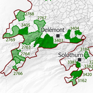
Change in Upper Rhine municipalities between 2006 and 2016
This map shows the changes in municipal administrative boundaries between 2006 and 2016 in the Upper Rhine area.
Simple
- Date (Creation)
- 2016-01-01
- Date (Publication)
- 2016-06-20
- Citation identifier
- 04_2016_0232
- Status
- Completed
- Point of contact
-
Organisation name Individual name Electronic mail address Role GeoRhena
GeoRhena
Processor
- Maintenance and update frequency
- Not planned
- Keywords
-
-
Map
-
- Keywords
-
-
Upper Rhine
-
-
GEMET - Concepts, version 2.4
-
-
administrative boundary
-
geography
-
co-operation policy
-
- Use limitation
-
Licence CC BY
- Access constraints
- Other restrictions
- Use constraints
- Other restrictions
- Other constraints
-
No other limitation
- Denominator
- 100000
- Language
- Français
- Character set
- UTF8
- Topic category
-
- Boundaries
- Begin date
- 2006-01-01
- End date
- 2016-12-31
N
S
E
W
))
- Distribution format
-
Name Version PDF Map
-
- OnLine resource
-
Protocol Linkage Name WWW:DOWNLOAD-1.0-http--download
https://www.georhena.eu/sites/default/files/Cartes/04_2016_0232.pdf Pdf Download
Metadata
- File identifier
- f02c5a68-3616-45d9-a01b-6540e4497238 XML
- Metadata language
- Français
- Character set
- UTF8
- Hierarchy level
- Static map
- Hierarchy level name
-
Carte statique
- Date stamp
- 2022-09-20T14:54:16.99867Z
- Metadata standard name
-
ISO 19115:2003/19139
- Metadata standard version
-
1.0
- Metadata author
-
Organisation name Individual name Electronic mail address Role GeoRhena: Geographical Information System of the Upper Rhine
Author
- Other language
-
Language Character encoding German UTF8 English UTF8 French UTF8
)))
