 Demo Catalogue powered by geOrchestra
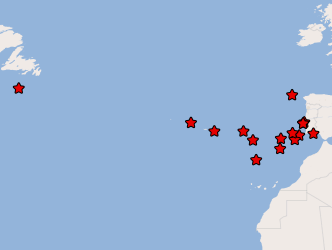
WMS Origin of Tsunamis in Portugal
Earthquakes (epicenters) and areas that mark large submarine landslides of sedimentary material, which caused tsunamis whose impact was recorded on the Portuguese coast.
Simple
Identification info
- Date (Creation)
- 2016-05-06
- Citation identifier
- http://ipma.pt/observations/geology/sdg / 8fcbde89-184f-472d-9a06-c6556fce31e6
- Citation identifier
- tsunamisorigin
- Point of contact
-
Organisation name Individual name Electronic mail address Role Instituto Português do Mar e da Atmosfera, I.P. (IPMA, I.P.)
Divisão de Sistemas de Informação, Comunicações e Desenvolvimento Tecnológico (DivSI)
Point of contact
- Maintenance and update frequency
- As needed
-
ISO - 19119 geographic services taxonomy
-
-
infoMapAccessService
-
-
Thesaurus SNIMar v.1.x
-
-
Deslizamento de terra
-
-
Thesaurus SNIMar v.1.x
-
-
Tsunami
-
-
Thesaurus SNIMar v.1.0
-
-
Oceanografia
-
-
Thesaurus SNIMar v.1.0
-
-
Geologia Marinha e Costeira
-
- Keywords
-
-
IPMA, I.P.
-
Sismos
-
- Use limitation
-
Sem restrições
- Access constraints
- Other restrictions
- Use constraints
- Other restrictions
- Other constraints
-
O acesso à informação disponibilizada é público mas a sua utilização não poderá ter fins lucrativos ou ofensivos e deverá, sempre, referir a fonte de informação IPMA, I.P.
- Service Type
- view
))
- Coupling Type
- Tight
- Contains Operations
-
Operation Name Distributed Computing Platforms Connect Point GetMap
Web services http://maps.ipma.pt/mapserv?map=/var/www/maps/observations/geology/tsunamisorigin_wms.map GetCapabilities
Web services http://maps.ipma.pt/mapserv?map=/var/www/maps/observations/geology/tsunamisorigin_wms.map GetFeatureInfo
Web services http://maps.ipma.pt/mapserv?map=/var/www/maps/observations/geology/tsunamisorigin_wms.map
- Reference system identifier
- EPSG / http://www.opengis.net/def/crs/EPSG/0/4258
- Reference system identifier
- EPSG / http://www.opengis.net/def/crs/EPSG/0/4326
- Distribution format
-
Name Version WMS
1.3
- OnLine resource
-
Protocol Linkage Name http://maps.ipma.pt/mapserv?map=/var/www/maps/observations/geology/tsunamisorigin_wms.map
- Hierarchy level
- Service
Extent
- Dataset
-
8fcbde89-184f-472d-9a06-c6556fce31e6
- Dataset
-
tsunamisorigin
Conformance result
- Date (Publication)
- 2010-11-23
- Explanation
-
Ver a especificação citada.
- Pass
- No
Metadata
- File identifier
- e859ee48-425a-418f-b09e-e12dd671c3eb XML
- Metadata language
- Portuguese
- Character set
- UTF8
- Hierarchy level
- Service
- Date stamp
- 2017-04-10
- Metadata standard name
-
Perfil SNIMar
- Metadata standard version
-
v.0.9.3
- Metadata author
-
Organisation name Individual name Electronic mail address Role Instituto Português do Mar e da Atmosfera, I.P. (IPMA, I.P.)
Point of contact
- Other language
-
Language Character encoding English UTF8
Overviews
Spatial extent
Provided by
