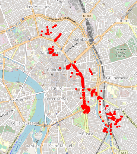
Toulouse 2015 Supervised SVN classification results for 600 urban trees according to a 3 level nomenclature
Hyperspectral data were obtained during an acquisition campaign led on Toulouse (France) urban area on July 2015 using Hyspex instrument which provides 408 spectral bands spread over 0.4 – 2.5 μ. Flight altitude lead to 2 m spatial resolution images. Supervised SVN classification results for 600 urban trees according to a 3 level nomenclature: leaf type (5 classes), family (12 and 19 classes) and species (14 and 27 classes). The number of classes differ for the two latter as they depend on the minimum number of individuals considered (4 and 10 individuals per class respectively). Trees positions have been acquired using differential GPS and are given with centimetric to decimetric precision. A randomly selected subset of these trees has been used to train machine SVM and Random Forest classification algorithms. Those algorithms were applied to hyperspectral images using a number of classes for family (12 and 19 classes) and species (14 and 27 classes) levels defined according to the minimum number of individuals considered during training/validation process (4 and 10 individuals per class, respectively). Global classification precision for several training subsets is given by Brabant et al, 2019 ( https://www.mdpi.com/470202) in terms of averaged overall accuracy (AOA) and averaged kappa index of agreement (AKIA).
Simple
- Date (Revision)
- 2022-05-17T19:09:06
- Edition
-
1.0
- Edition date
- 2015-01-01
- Citation identifier
- e324c038-08f3-4a11-aca2-7abbeda014e7
- Cited responsible party
-
Organisation name Individual name Electronic mail address Role UMR TETIS - CNRS
Christiane Weber
Principal investigator
- Purpose
-
Provide with urban trees 3 level nomenclature
- Status
- Completed
- Point of contact
-
Organisation name Individual name Electronic mail address Role UMR TETIS - CNRS
Christiane Weber
Principal investigator
- Maintenance and update frequency
- Not planned
-
General
-
-
remote sensing
-
VHRS imagery
-
HYPERSPECTRAL imagery
-
urban studies
-
- Use limitation
-
This work is licensed under a Creative Commons Attribution 4.0 License (CC BY 4.0, https://creativecommons.org/licenses/by/4.0).
- Access constraints
- License
- Use constraints
- License
- Classification
- Unclassified
- User note
-
unclassified
- Classification system
-
no classification in particular
- Handling description
-
description
- Spatial representation type
- Vector
- Language
- English
- Character set
- UTF8
- Topic category
-
- Geoscientific information
- Environment
))
- Begin date
- 2015-07-01T00:00:00Z
- End date
- 2015-07-31T00:00:00Z
- Supplemental Information
-
some additional information
- Reference system identifier
- EPSG / 4326
- Distribution format
-
Name Version ESRI Shapefile
1.0
- OnLine resource
-
Protocol Linkage Name file for download
https://zenodo.org/record/3611240/files/Fields_samples.7z?download=1 geopackage file
OGC:WMS
http://idg-tetis-gs.teledetection.fr:8080/geoserver/idg-tetis/wms species_27classes
- Hierarchy level
- Dataset
Conformance result
- Title
-
Data Quality check
- Alternate title
-
This is is some data quality check report
- Date (Publication)
- 2022-05-17T19:09:06
- Explanation
-
some explanation about the conformance
- Pass
- Yes
Conformance result
- Title
-
Commission Regulation (EU) No 1089/2010 of 23 November 2010 implementing Directive 2007/2/EC of the European Parliament and of the Council as regards interoperability of spatial data sets and services
- Date (Publication)
- 2010-12-08T12:00:00
- Explanation
-
See the referenced specification
- Pass
- Yes
Conformance result
- Title
-
COMMISSION REGULATION (EC) No 1205/2008 of 3 December 2008 implementing Directive 2007/2/EC of the European Parliament and of the Council as regards metadata
- Date (Publication)
- 2008-12-04T12:00:00
- Explanation
-
See the referenced specification
- Pass
- Yes
- Statement
-
Hyperspectral data were obtained during an acquisition campaign led on Toulouse (France) urban area on July 2015 using Hyspex instrument which provides 408 spectral bands spread over 0.4 – 2.5 μ. Flight altitude lead to 2 m spatial resolution images. Supervised SVN classification results for 600 urban trees according to a 3 level nomenclature: leaf type (5 classes), family (12 and 19 classes) and species (14 and 27 classes). The number of classes differ for the two latter as they depend on the minimum number of individuals considered (4 and 10 individuals per class respectively). Trees positions have been acquired using differential GPS and are given with centimetric to decimetric precision. A randomly selected subset of these trees has been used to train machine SVM and Random Forest classification algorithms. Those algorithms were applied to hyperspectral images using a number of classes for family (12 and 19 classes) and species (14 and 27 classes) levels defined according to the minimum number of individuals considered during training/validation process (4 and 10 individuals per class, respectively). Global classification precision for several training subsets is given by Brabant et al, 2019 ( https://www.mdpi.com/470202) in terms of averaged overall accuracy (AOA) and averaged kappa index of agreement (AKIA).
Metadata
- File identifier
- e324c038-08f3-4a11-aca2-7abbeda014e7 XML
- Metadata language
- English
- Character set
- UTF8
- Parent identifier
-
83867504-286c-4436-b3fc-436ffdc1d912
83867504-286c-4436-b3fc-436ffdc1d912
- Hierarchy level
- Dataset
- Date stamp
- 2022-05-17T19:25:04
- Metadata standard name
-
ISO 19115:2003/19139
- Metadata standard version
-
1.0
- Metadata author
-
Organisation name Individual name Electronic mail address Role LETG - Univ Rennes 2
Thomas Houet
Point of contact UMR TETIS - CNRS
Christiane Weber
Principal investigator UMR TETIS - CNRS
Claudia Lavalley
Claudia. Lavalley@cnrs.fr
Publisher
Overviews

Spatial extent
)))
Provided by

 Demo Catalogue powered by geOrchestra