 Demo Catalogue powered by geOrchestra
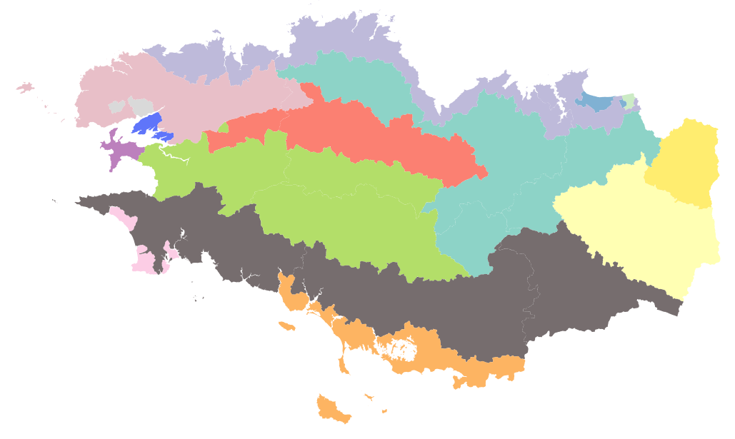
Petites régions agricoles de Bretagne
Les Petites Régions Agricoles (PRA) sont les intersections des Régions Agricoles avec les départements. Les Régions Agricoles (RA) elles-mêmes sont des régions ayant une même vocation agricole dominante, délimitées par l'INSEE en 1946. La dernière actualisation date de 2017. Source AGRESTE : https://agreste.agriculture.gouv.fr/agreste-web/methodon/Z.1/!searchurl/listeTypeMethodon/
Simple
- Date (Publication)
- 2018-05-17T14:00:00
- Citation identifier
- fr-18007003900276-umrsas-parchemins-pra_bzh
- Presentation form
- Digital map
- Status
- Completed
- Point of contact
-
Organisation name Individual name Electronic mail address Role UMR 1069 SAS INRA - Agrocampus Ouest
coordination Parchemins
Originator
- Maintenance and update frequency
- As needed
- Keywords
-
-
données ouvertes
-
-
GéoBretagne v 2.0
-
-
limites administratives et découpage des territoires : autres
-
activité économique : agriculture et élevage
-
-
INSPIRE themes
-
-
Unités administratives
-
Unités statistiques
-
- Use limitation
-
Usage libre sous réserve des mentions obligatoires sur tout document de diffusion : "Source : UMR 1069 SAS INRA - Agrocampus Ouest / UMR 1326 LISIS INRA"
- Use limitation
-
Licence ouverte : https://www.etalab.gouv.fr/licence-ouverte-open-licence
- Access constraints
- Other restrictions
- Use constraints
- License
- Other constraints
-
Pas de restriction d’accès public
- Spatial representation type
- Vector
- Denominator
- 100000
- Language
-
fre
- Character set
- UTF8
- Topic category
-
- Boundaries
))
- Reference system identifier
- EPSG / WGS 84 / 7.4
- Distribution format
-
Name Version ESRI Shapefile
1.0
- Distributor contact
-
Organisation name Individual name Electronic mail address Role UMR 1069 SAS INRA - Agrocampus Ouest
Service GéoSAS
Distributor
- OnLine resource
-
Protocol Linkage Name OGC:WMS
https://geosas.fr/geoserver/parchemins/pra_bzh/ows pra_bzh
- OnLine resource
-
Protocol Linkage Name WWW:DOWNLOAD-1.0-http--download
https://geosas.fr/geoserver/wfs?service=WFS&version=2.0.0&request=GetFeature&typeName=parchemins:pra_bzh&outputFormat=SHAPE-ZIP
- OnLine resource
-
Protocol Linkage Name WWW:LINK-1.0-http--link
http://www.parchemins.bzh site du projet Parchemins
- Hierarchy level
- Dataset
- Statement
Metadata
- File identifier
- e08b3a98-6b7e-468e-a014-02e4017145b7 XML
- Metadata language
-
fre
- Character set
- UTF8
- Hierarchy level
- Dataset
- Date stamp
- 2021-01-07T11:07:50
- Metadata standard name
-
ISO 19115:2003/19139
- Metadata standard version
-
1.0
- Metadata author
-
Organisation name Individual name Electronic mail address Role UMR 1069 SAS INRA
coordination Parchemins
Point of contact
Overviews
Spatial extent
Provided by
