 Demo Catalogue powered by geOrchestra
Assessment of contamination status of biota using CHASE+, Mar. 2019
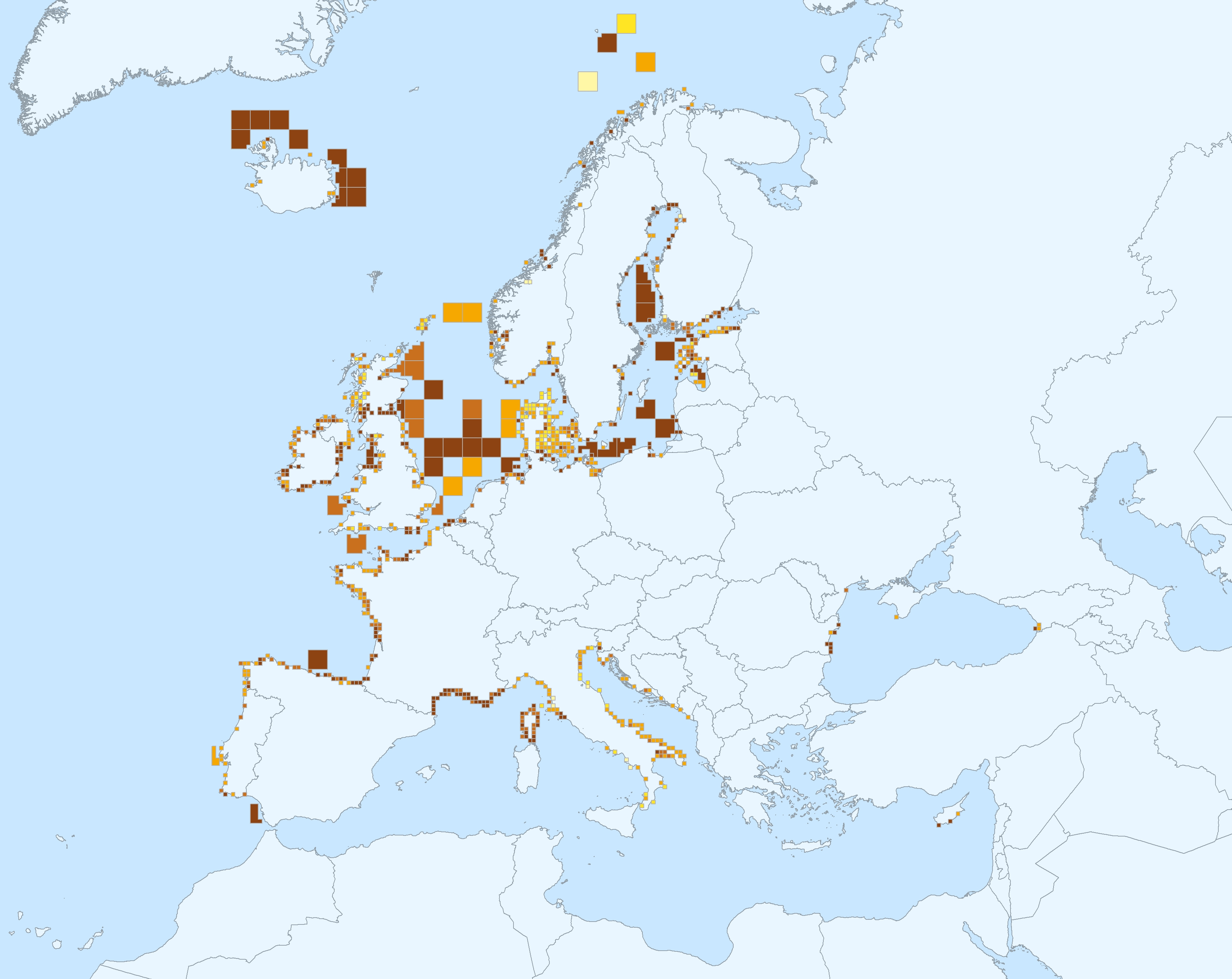
This data set presents the resulting assessment grid (based on the EEA reference grid) with the classification of chemical status of the transitional, coastal and marine waters in the context of the Water Framework Directive (WFD) and the Marine Strategy Framework Directive (MSFD), with a mapping of contamination 'problem areas' and ‘non-problem areas’ based on measurements in the matrix 'biota'.
This classification has been performed using the CHASE+ tool, with classifications of the biota matrix. The chemical status is evaluated in five classes, where NPAhigh and NPAgood are recognised as ‘non-problem areas’ and PAmoderate, PApoor and PAbad are recognised as ‘problem areas’.
Monitoring and assessment for the matrix 'biota' has been carried out in the North-East Atlantic Ocean (482 assessment units), Baltic sea (198 assessment units), Mediterranean Sea (161 assessment units) and Black sea (12 assessment units).
This data set underpins the findings and cartographic representations published in the EEA report “Contaminants in Europe’s seas” (No 25/2018): https://www.eea.europa.eu/publications/contaminants-in-europes-seas. See the mentioned report for further information as well as examples of classification excluding specific groups of substances (e.g. metals, PBDEs).
Simple
- Date (Creation)
- 2019-03-06
- Date (Publication)
- 2019-03-21
- Edition
-
01.00
- Citation identifier
- eea_v_3857_20_km_chase-biota_p_2009-2016_v01_r00
- Citation identifier
- DAT-211-en
- Point of contact
-
Organisation name Individual name Electronic mail address Role European Environment Agency
Point of contact European Environment Agency
Custodian
Point of contact
- Maintenance and update frequency
- As needed
- Keywords
-
- Keywords
-
-
GEMET
-
-
environment
-
marine biology
-
aquatic environment
-
contamination
-
good chemical status
-
sea water
-
sea
-
marine ecosystem
-
indicator-based assessment
-
marine biota
-
ocean
-
environmental quality
-
-
Continents, countries, sea regions of the world.
-
-
Norwegian Sea
-
North Sea
-
Ionian Sea
-
Kattegat
-
Bay of Biscay
-
Baltic Sea
-
Mediterranean Sea
-
Black Sea
-
Celtic Sea
-
Barents Sea
-
English Channel
-
Adriatic Sea
-
Iceland Sea
-
-
Spatial scope
-
-
European
-
-
EEA Management Plan
-
-
2018 1.6.2
-
-
EEA topics
-
-
Chemicals
-
Seas and coasts
-
Water
-
Biodiversity
-
Pollution
-
-
Sous-regions marines
-
-
/Métropole
-
/Métropole/Manche mer du Nord
-
/Métropole/Mers Celtiques
-
/Métropole/Golfe de Gascogne
-
/Métropole/Méditerranée occidentale
-
-
Thématiques - SIMM
-
-
/Etat du Milieu/Habitats
-
-
Thématiques - SIMM
-
-
/Etat du Milieu/Pollutions
-
-
Type de jeux de donnée - ODATIS
-
-
/Données dérivées/Indicateurs
-
-
Type de jeux de donnée - ODATIS
-
-
/Données dérivées/Produits composites
-
-
Cadre Réglementaire - SIMM
-
-
Directive Cadre Stratégie pour le Milieu Marin (DCSMM)
-
-
Cadre Réglementaire - SIMM
-
-
Directive Cadre sur l'Eau (DCE)
-
- Access constraints
- Other restrictions
- Other constraints
- no limitations to public access
- Use constraints
- Other restrictions
- Other constraints
-
EEA standard re-use policy: unless otherwise indicated, re-use of content on the EEA website for commercial or non-commercial purposes is permitted free of charge, provided that the source is acknowledged ( http://www.eea.europa.eu/legal/copyright ). Copyright holder: European Environment Agency (EEA).
- Aggregate Datasetindentifier
- e542e9a1-715a-48e2-8c6c-d8a30541ca93
- Association Type
- Cross reference
- Aggregate Datasetindentifier
- 49eb412e-3002-492c-8323-ab5cac07fc40
- Association Type
- Cross reference
- Aggregate Datasetindentifier
- cd87cd22-0a6f-499b-9e27-9691e6e46030
- Association Type
- Cross reference
- Aggregate Datasetindentifier
- 3feffd63-ab0b-4f03-84e8-b2c324c93bbe
- Association Type
- Cross reference
- Aggregate Datasetindentifier
- 7c66cfd5-4246-4b9d-86af-624950aa49d4
- Association Type
- Cross reference
- Spatial representation type
- Vector
- Distance
- 20 km
- Distance
- 100 km
- Language
- English
- Topic category
-
- Environment
- Oceans
))
- Begin date
- 2009-01-01
- End date
- 2016-12-31
- Unique resource identifier
- EPSG:3857
- Distribution format
-
Name Version SHP
- OnLine resource
-
Protocol Linkage Name EEA:FILEPATH
https://sdi.eea.europa.eu/webdav/datastore/public/eea_v_3857_20_km_chase-biota_p_2009-2016_v01_r00/CHASE_Contaminants_biota_WGS84.shp WWW:URL
https://sdi.eea.europa.eu/data/dfe9061b-84ad-4ef1-ba83-519ab61ebb40 Direct download
WWW:LINK-1.0-http--link
https://www.eea.europa.eu/publications/contaminants-in-europes-seas Contaminants in Europe's seas
WWW:DOWNLOAD-1.0-http--download
https://sdi.eea.europa.eu/catalogue/srv/api/records/49eb412e-3002-492c-8323-ab5cac07fc40/attachments/Contaminants-in-Europes-seas-online-material-INPUT.xlsx Contaminants in Europes seas INPUT material
WWW:DOWNLOAD-1.0-http--download
https://sdi.eea.europa.eu/catalogue/srv/api/records/49eb412e-3002-492c-8323-ab5cac07fc40/attachments/Contaminants-in-Europes-seas-online-material-RESULTS-final.xlsx Contaminants in Europes seas RESULTS-material
- OnLine resource
-
Protocol Linkage Name ESRI:REST
https://marine.discomap.eea.europa.eu/arcgis/rest/services/Marine/CHASE_contaminants_Biota/MapServer CHASE based classification of contaminant status of Biota
OGC:WMS
https://marine.discomap.eea.europa.eu/arcgis/services/Marine/CHASE_contaminants_Biota/MapServer/WMSServer?request=GetCapabilities&service=WMS
- Hierarchy level
- Dataset
Conformance result
- Date (Publication)
- Statement
-
This assessment is based on data on contaminants, monitored in transitional, coastal and marine waters in the context of the WFD and the MSFD. For this analysis, Europe's seas were divided into grid cells of 20 × 20 km2 in coastal waters and 100 × 100 km2 in offshore areas. The CHASE+ methodology is a simple five-step procedure applied in every assessment unit. For 'biota', a contaminant ratio (CR = Cstatus/Cthreshold) and score (CS) are calculated. The values are then subdivided into five status classes with class boundaries: 0.0-0.5 (NPAhigh), 0.5-1.0 (NPAgood), 1.0-5.0 (PAmoderate), 5.0-10.0 (PApoor) and > 10.0 (PAbad).
Based on the EEA reference grid, two grids have been developed covering the Marine Regions and Sub-regions of Europe. The first grid 100x100 km cell is used in offshore areas (> 20 km from the coastline); the second grid 20x20 km covers the coastal areas (<= 20 km from the coastline). The grid sizes were chosen after an evaluation of data availability versus the need for sufficient detail in the resulting assessment. Each cell in the grids has a unique identification defined from the lower left UTM coordinates. The CHASE+ results are associated to the unique cells in the grids.
More information can be found in the report "Contaminants in Europe's seas" and online material on https://www.eea.europa.eu/publications/contaminants-in-europes-seas/ .
Metadata
- File identifier
- dfe9061b-84ad-4ef1-ba83-519ab61ebb40 XML
- Metadata language
- English
- Character set
- UTF8
- Hierarchy level
- Dataset
- Date stamp
- 2023-03-07T16:53:33.312Z
- Metadata standard name
-
ISO 19115/19139
- Metadata standard version
-
1.0
- Metadata author
-
Organisation name Individual name Electronic mail address Role European Environment Agency
Point of contact
Overviews
Spatial extent
Provided by
