 Demo Catalogue powered by geOrchestra
Mbozo-Wazan : peul et montagnards au nord du Cameroun. Scale of 1:20 000 to 1:5 000. Date of publication: 1986.
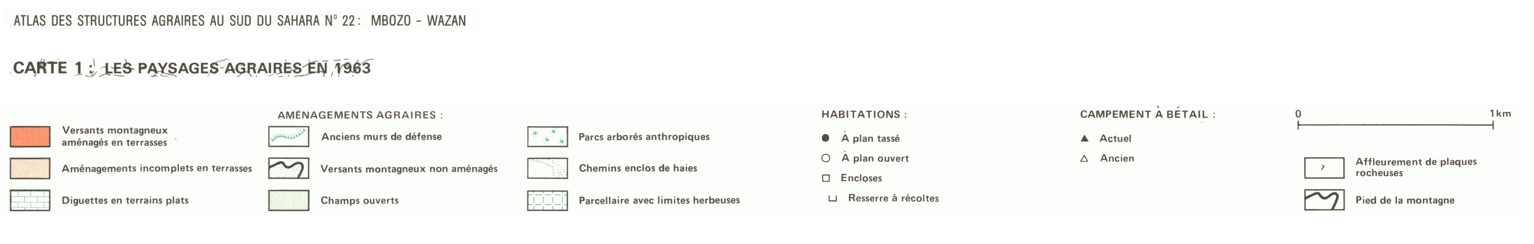
1. Carte 1 : les paysages agraires en 1963. / Boutrais, Jean; Valton, C.; Scale of 1:20 000. Date of publication: 1986. (file: 01763RC_IRD_CMR_AGPA_1986_20000_IRD_CMR_CSRE_1986_20000-5000.tif)
2. Carte 2 : l'occupation des sols en 1963. / Boutrais, Jean; Valton, C.; Scale of 1:20 000. Date of publication: 1986. (file: 01764RC_IRD_CMR_USOL_1986_20000_IRD_CMR_CSRE_1986_20000-5000.tif)
3. Carte 3 : le peuplement en 1963. / Boutrais, Jean; Valton, C.; Scale of 1:20 000. Date of publication: 1986. (file: 01765RC_IRD_CMR_POPE_1986_20000_IRD_CMR_CSRE_1986_20000-5000.tif)
4. Carte 4 : les nouveaux terroirs de migrants montagnards à Makabay, près de Maroua (1969). / Boutrais, Jean; Valton, C.; Scale of 1:5 000. Date of publication: 1986. (file: 01766RC_IRD_CMR_POMI_1986_5000_IRD_CMR_CSRE_1986_20000-5000.tif)
5. Carte 5 : les migrations rurales de 1963 à 1983. / Boutrais, Jean; Valton, C.; Scale of 1:20 000. Date of publication: 1986. (file: 01767RC_IRD_CMR_POMI_1986_20000_IRD_CMR_CSRE_1986_20000-5000.tif)
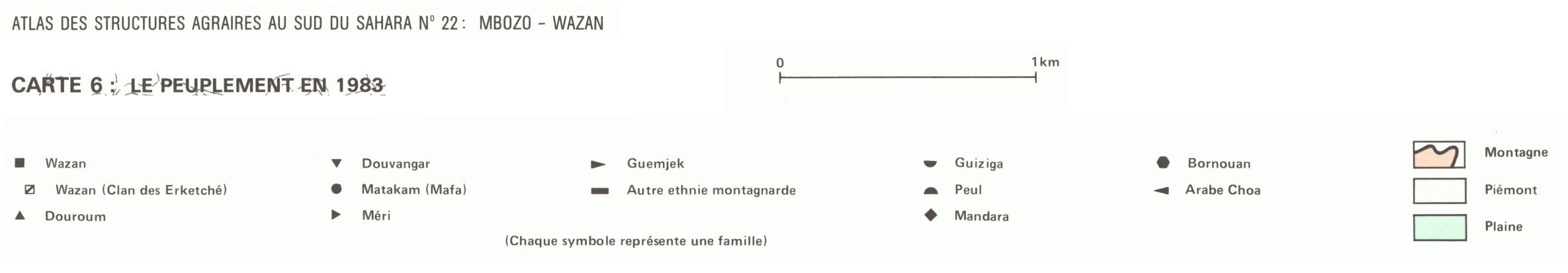
6. Carte 6 : le peuplement en 1983. / Boutrais, Jean; Valton, C.; Scale of 1:20 000. Date of publication: 1986. (file: 01768RC_IRD_CMR_POPE_1986_20000_IRD_CMR_CSRE_1986_20000-5000.tif)
7. Carte 7 : l'occupation du sol en 1983. / Boutrais, Jean; Valton, C.; Scale of 1:20 000. Date of publication: 1986. (file: 01769RC_IRD_CMR_USOL_1986_20000_IRD_CMR_CSRE_1986_20000-5000.tif)
Simple
- Date (Publication)
- 1986-01-01
- Citation identifier
- IRD_CMR_CSRE_1986_20000-5000
- Credit
-
The region Île-de-France, under the project NumeriSud, supported the action to transforme around 2800 maps that are conserved at the Institut de recherche pour le développement (IRD) library in Bondy into a standard coordinate system. The transformation of the images has been done by Global Mapping Resources (South Africa) under the supervision of R. Zaiss (éditeur) 2014.
- Status
- Completed
- Point of contact
-
Organisation name Individual name Electronic mail address Role Institut de recherche pour le développement (IRD)
Production cartographique IRD
Point of contact Boutrais, Jean
Author Valton, C.
Author ORSTOM, Institut français de recherche scientifique pour le développement en coopération, Unité de cartographie
editor
- Maintenance and update frequency
- Not planned
-
Geounits
-
-
Africa
-
Middle Africa
-
Cameroon
-
- Theme
-
-
cultural aptitudes, actual productivity
-
settlements
-
thematic map
-
- Keywords
-
-
project NumeriSud
-
map collection
-
local coverage
-
- Use limitation
-
Licence : CC-BY-NC-SA
- Access constraints
- licence
- Classification
- Unclassified
- Spatial representation type
- Grid
- Denominator
- 5000
- Language
- Français
- Character set
- UTF8
- Topic category
-
- Farming
- Geoscientific information
- Planning cadastre
- Society
))
- Begin date
- 1986-01-01
- End date
- 1986-12-31
- Supplemental Information
-
Publication(s):
Boutrais, J. (1986): Mbozo-Wazan : peul et montagnards au nord du Cameroun. Paris (FRA) : ORSTOM, Institut français de recherche scientifique pour le développement en coopération, Unité de cartographie.
- Reference system identifier
- EPSG / 4326 / 7.9
- Distribution format
-
Name Version GeoTIFF
1.0
- Distributor contact
-
Organisation name Individual name Electronic mail address Role DataSuds-geo
Publisher
- OnLine resource
-
Protocol Linkage Name OGC:WMS
https://datasuds-geo.ird.fr/geoserver/wms sphaera_ws:01763RC_IRD_CMR_AGPA_1986_20000_IRD_CMR_CSRE_1986_20000-5000
WWW:DOWNLOAD:GeoTIFF https://datasuds-geo.ird.fr/geoserver/ows?service=WCS&version=2.0.1&request=GetCoverage&coverageId=01763RC_IRD_CMR_AGPA_1986_20000_IRD_CMR_CSRE_1986_20000-5000 WWW:LINK-1.0-http--related
https://www.documentation.ird.fr/hor/fdi:23531 Notice explicative ou autre ouvrage
- OnLine resource
-
Protocol Linkage Name OGC:WMS
https://datasuds-geo.ird.fr/geoserver/wms sphaera_ws:01764RC_IRD_CMR_USOL_1986_20000_IRD_CMR_CSRE_1986_20000-5000
WWW:DOWNLOAD:GeoTIFF https://datasuds-geo.ird.fr/geoserver/ows?service=WCS&version=2.0.1&request=GetCoverage&coverageId=01764RC_IRD_CMR_USOL_1986_20000_IRD_CMR_CSRE_1986_20000-5000 WWW:LINK-1.0-http--related
https://www.documentation.ird.fr/hor/fdi:23531 Notice explicative ou autre ouvrage
- OnLine resource
-
Protocol Linkage Name OGC:WMS
https://datasuds-geo.ird.fr/geoserver/wms sphaera_ws:01765RC_IRD_CMR_POPE_1986_20000_IRD_CMR_CSRE_1986_20000-5000
WWW:DOWNLOAD:GeoTIFF https://datasuds-geo.ird.fr/geoserver/ows?service=WCS&version=2.0.1&request=GetCoverage&coverageId=01765RC_IRD_CMR_POPE_1986_20000_IRD_CMR_CSRE_1986_20000-5000 WWW:LINK-1.0-http--related
https://www.documentation.ird.fr/hor/fdi:23531 Notice explicative ou autre ouvrage
- OnLine resource
-
Protocol Linkage Name OGC:WMS
https://datasuds-geo.ird.fr/geoserver/wms sphaera_ws:01766RC_IRD_CMR_POMI_1986_5000_IRD_CMR_CSRE_1986_20000-5000
WWW:DOWNLOAD:GeoTIFF https://datasuds-geo.ird.fr/geoserver/ows?service=WCS&version=2.0.1&request=GetCoverage&coverageId=01766RC_IRD_CMR_POMI_1986_5000_IRD_CMR_CSRE_1986_20000-5000 WWW:LINK-1.0-http--related
https://www.documentation.ird.fr/hor/fdi:23531 Notice explicative ou autre ouvrage
- OnLine resource
-
Protocol Linkage Name OGC:WMS
https://datasuds-geo.ird.fr/geoserver/wms sphaera_ws:01767RC_IRD_CMR_POMI_1986_20000_IRD_CMR_CSRE_1986_20000-5000
WWW:DOWNLOAD:GeoTIFF https://datasuds-geo.ird.fr/geoserver/ows?service=WCS&version=2.0.1&request=GetCoverage&coverageId=01767RC_IRD_CMR_POMI_1986_20000_IRD_CMR_CSRE_1986_20000-5000 WWW:LINK-1.0-http--related
https://www.documentation.ird.fr/hor/fdi:23531 Notice explicative ou autre ouvrage
- OnLine resource
-
Protocol Linkage Name OGC:WMS
https://datasuds-geo.ird.fr/geoserver/wms sphaera_ws:01768RC_IRD_CMR_POPE_1986_20000_IRD_CMR_CSRE_1986_20000-5000
WWW:DOWNLOAD:GeoTIFF https://datasuds-geo.ird.fr/geoserver/ows?service=WCS&version=2.0.1&request=GetCoverage&coverageId=01768RC_IRD_CMR_POPE_1986_20000_IRD_CMR_CSRE_1986_20000-5000 WWW:LINK-1.0-http--related
https://www.documentation.ird.fr/hor/fdi:23531 Notice explicative ou autre ouvrage
- OnLine resource
-
Protocol Linkage Name OGC:WMS
https://datasuds-geo.ird.fr/geoserver/wms sphaera_ws:01769RC_IRD_CMR_USOL_1986_20000_IRD_CMR_CSRE_1986_20000-5000
WWW:DOWNLOAD:GeoTIFF https://datasuds-geo.ird.fr/geoserver/ows?service=WCS&version=2.0.1&request=GetCoverage&coverageId=01769RC_IRD_CMR_USOL_1986_20000_IRD_CMR_CSRE_1986_20000-5000 WWW:LINK-1.0-http--related
https://www.documentation.ird.fr/hor/fdi:23531 Notice explicative ou autre ouvrage
- OnLine resource
-
Protocol Linkage Name DOI
https://doi.org/10.23708/dbdcea3e-0e36-4244-837b-ebfa15ad229c Digital Object Identifier (DOI)
- Hierarchy level
- Dataset
- Statement
-
1. Scanning to tif format, 256 colors, 250dpi.
2. Georeferencing and if possible reprojection to WGS84 (Longitude / Latitude).
3. Clipping and mosaicing of map sheets(s).
4. Export ECW format.
5. ECW to GeoTIFF format conversion.
Metadata
- File identifier
- dbdcea3e-0e36-4244-837b-ebfa15ad229c XML
- Metadata language
- English
- Character set
- UTF8
- Hierarchy level
- Dataset
- Hierarchy level name
-
dataset
- Date stamp
- 2024-02-13T18:36:46.814814Z
- Metadata standard name
-
ISO 19115:2003/19139
- Metadata standard version
-
1.0
- Metadata author
-
Organisation name Individual name Electronic mail address Role Institut de recherche pour le développement (IRD)
Service de l'Information Scientifique et Technique (IST) IRD
Point of contact Institut de recherche pour le développement (IRD)
IRD
Resource provider
Overviews


Spatial extent
Provided by
