 Demo Catalogue powered by geOrchestra
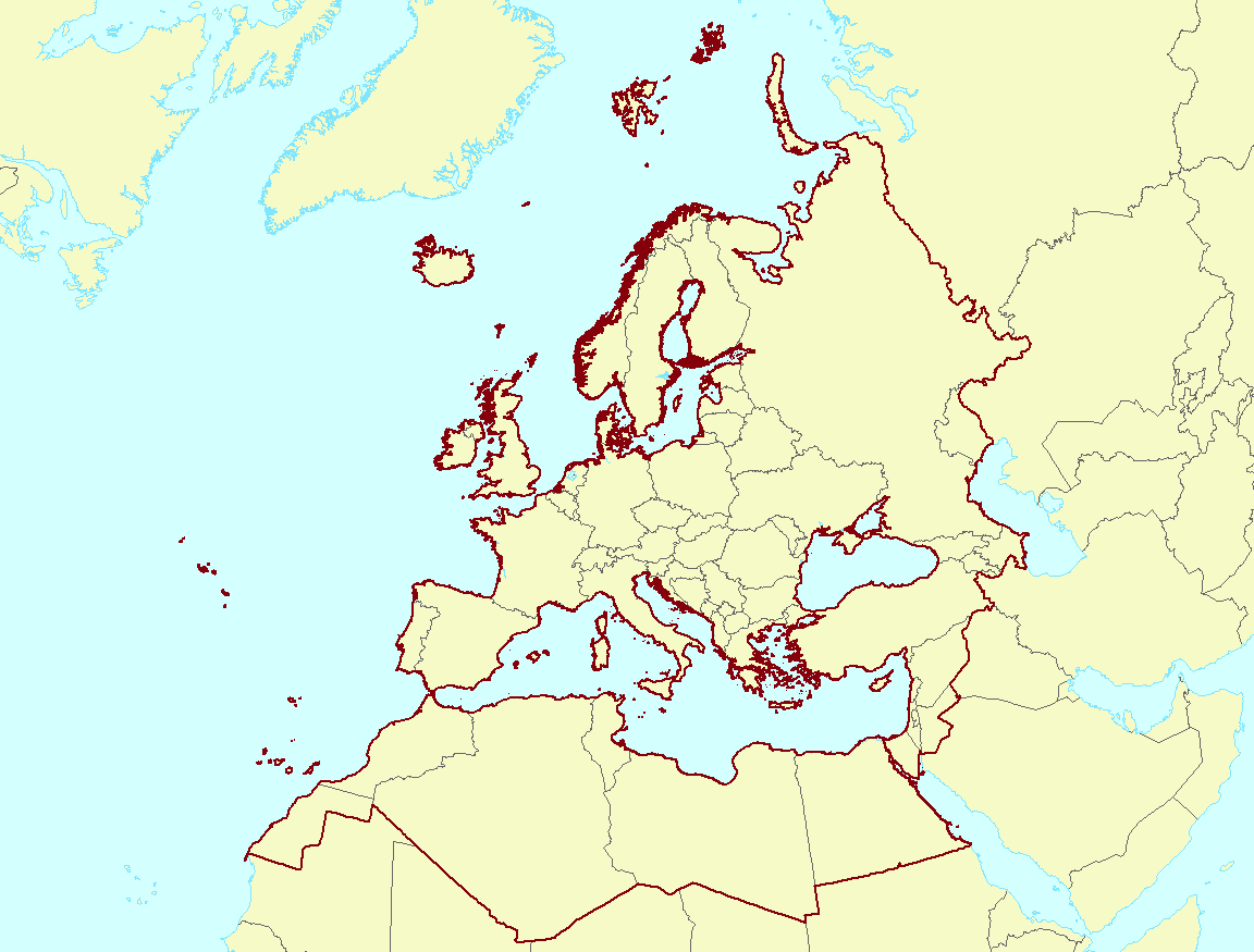
EEA coastline for analysis (raw) - version 3.0, Mar. 2017
The EEA coastline for analysis is created for highly detailed analysis, e.g. 1:100 000, for geographical Europe. The coastline is a hybrid product obtained from projects using satellite imagery as data source: EUHYDRO ( https://land.copernicus.eu/imagery-in-situ/eu-hydro ) and GSHHG ( http://www.soest.hawaii.edu/pwessel/gshhg/ ). The defining criteria was altitude level = 0 from EUDEM ( https://land.copernicus.eu/pan-european/satellite-derived-products/eu-dem/view ). Outside the coverage of the EUDEM, the coastline from GSHHG was used without modifications. A few manual amendments to the dataset were necessary to meet requirements from EU Nature Directives, Water Framework Directive and Marine Strategy Framework Directive. In 2015, several corrections were made in the Kalogeroi Islands (coordinates 38.169, 25.287) and two other Greek little islets (coordinates 36.766264, 23.604318), as well as in the peninsula of Porkkala (around coordinates 59.99, 24.42).
In this revision (v3, 2017), 2 big lagoons have been removed from Baltic region, because, according to HELCOM, are freshwater lagoons.
Simple
- Date (Creation)
- 2017-03-28
- Date (Publication)
- 2017-03-28
- Edition
-
3.0
- Citation identifier
- eea_v_3035_100_k_coastline-raw_1995-2012_p_v03_r00
- Citation identifier
- DAT-132-en
- Point of contact
-
Organisation name Individual name Electronic mail address Role European Environment Agency
Point of contact European Environment Agency
Custodian
- Maintenance and update frequency
- As needed
-
EEA topics
-
-
Biodiversity
-
-
GEMET - INSPIRE themes, version 1.0
-
-
Sea regions
-
- Keywords
-
-
Continents, countries, sea regions of the world.
-
-
Europe
-
- Keywords
-
-
GEMET
-
-
coastal area
-
coast
-
-
EEA Management Plan
-
-
2018 2.6.1
-
-
Sous-regions marines
-
-
/Métropole
-
/Métropole/Manche mer du Nord
-
/Métropole/Mers Celtiques
-
/Métropole/Golfe de Gascogne
-
/Métropole/Méditerranée occidentale
-
-
Thématiques - SIMM
-
-
/Etat du Milieu/Littoral
-
-
Type de jeux de donnée - ODATIS
-
-
/Données administratives
-
-
Type de jeux de donnée - ODATIS
-
-
/Données dérivées/Références statistiques
-
- Use limitation
-
EEA standard re-use policy: unless otherwise indicated, re-use of content on the EEA website for commercial or non-commercial purposes is permitted free of charge, provided that the source is acknowledged ( http://www.eea.europa.eu/legal/copyright ).
- Access constraints
- Other restrictions
- Other constraints
- no limitations to public access
- Association Type
- Source
- Association Type
- Source
- Association Type
- Source
- Spatial representation type
- Vector
- Denominator
- 100000
- Language
- English
- Character set
- UTF8
- Topic category
-
- Oceans
- Elevation
))
- Begin date
- 1995-08-01
- End date
- 2012-12-31
- Unique resource identifier
- EPSG:3035
- Distribution format
-
Name Version SHP
1.0
- OnLine resource
-
Protocol Linkage Name EEA:FILEPATH
https://sdi.eea.europa.eu/webdav/datastore/public/eea_v_3035_100_k_coastline-raw_1995-2012_p_v03_r00/Europe_coastline_raw_rev2017.shp ESRI:REST
https://marine.discomap.eea.europa.eu/arcgis/rest/services/Marine/EEA_coastline_v2017/MapServer EEA coastline for analysis - version 3.0, March 2017
OGC:WMS
https://marine.discomap.eea.europa.eu/arcgis/services/Marine/EEA_coastline_v2017/MapServer/WMSServer?request=GetCapabilities&service=WMS WWW:URL
https://sdi.eea.europa.eu/data/db4cfdd3-0687-4460-a2c7-fd10ca29c214 Direct download
- Hierarchy level
- Dataset
Conformance result
- Date (Publication)
- 2010-12-08
- Explanation
-
See the referenced specification
- Statement
-
The criteria for defining the coastline is the line separating water from land. The EEA coastline is a product derived from two sources: EUHYDRO ( https://land.copernicus.eu/imagery-in-situ/eu-hydro ) and GSHHG ( http://www.soest.hawaii.edu/pwessel/gshhg/ ) A priority defined in the input data, first EUHYDRO geometry and, as auxiliary data, GSHHG dataset. The EUHYDRO do not cover the required extension of EEA coastline. The EUHYDRO gaps are in Iceland, Canarias, Madeira, Azores, small islands (not represented in EUDEM) and the northern of Black Sea. For that reason, the GSHHG dataset is an input for the process which allow to populate the EUHYDRO shapefile.
The creation process was focused on generate the coastline as line datasets and, later, as secondary product, defining the polygon layer sea-land. Thank reiterative processes based on conversion (from water mask of EUHYDRO to polygon), selection, dissolving and conversion (to line) tools, it was possible to obtain a continuous and homogeneous coastline. The fundamental step into the workflow was the selection of sea features using the water mask polygon (with 255 value into EUHYDRO datasets). The inland water bodies (freshwaters) are rejected by these criteria, except the water bodies connected, at least by one point, to the sea (it is the cases of some transitional water bodies).
Two Baltic lagoons have been modified with the data from SVAR geodatabase version 2012_2, Swedish Meteorological and Hydrological Institute (SMHI).
The patchwork coastline has been subjected to quality assessment based on evaluate the degree of coverage and topological errors.
Metadata
- File identifier
- db4cfdd3-0687-4460-a2c7-fd10ca29c214 XML
- Metadata language
- English
- Character set
- UTF8
- Hierarchy level
- Dataset
- Date stamp
- 2024-06-12T10:44:53.480151Z
- Metadata standard name
-
ISO 19115/19139
- Metadata standard version
-
1.0
- Metadata author
-
Organisation name Individual name Electronic mail address Role European Environment Agency
Point of contact
Overviews
Spatial extent
Provided by
