 Demo Catalogue powered by geOrchestra
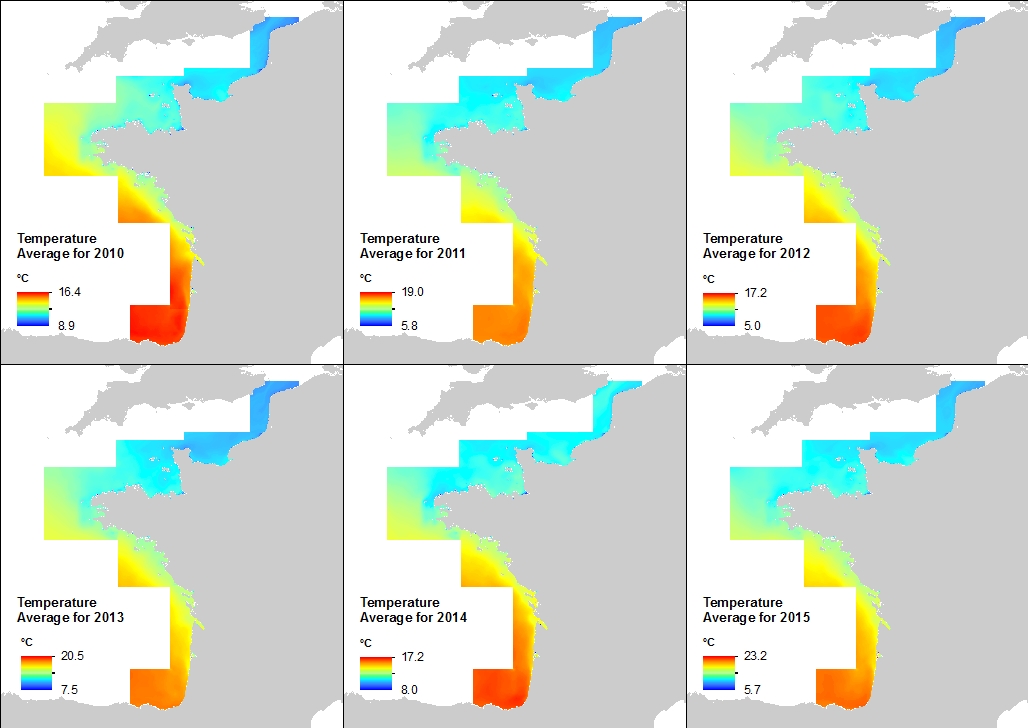
Manche-Gascogne - 500m - Température à la surface de l'océan
Annual Statistics of 500m Temperature at the Sea Surface - Biscay-Channel
Cette climatologie à la résolution spatiale de 500 mètres a été établie à partir des archives de série temporelles issues du rejeu hydrodynamique réalisée avec le modèle MARS 3D et la librairie AGRIF le long de la façade atlantique française. La variable mise à disposition est la Température. Les valeurs sont exprimées en degré Celsius. Le niveau vertical considéré est la surface de l'océan.
This annual statistics at 500m horizontal resolution was produced from the archived time series of MARS 3D physics model hindcast runs along French Atlantic Coast. The variable that is available here is the Temperature. Values are expressed in Celsius Degrees. The vertical level is the sea surface.
Simple
-
Date (Publication)Date (Publication)
- 2016-10-20
-
Citation identifierIdentificateur
- MANGA500_TEMPERATURE_AT_SURFACE
-
Citation identifierIdentificateur
- DOI:10.12770/db2637b4-9243-4f69-b122-403081fa6b60
-
ButPurpose
-
Cette climatologie a été produite dans le but de contribuer au Catalogue sédimentologique des côtes de Françaises édités par le Cerema (Centre d’études et d’expertise sur les risques, l’environnement, la mobilité et l’aménagement).
This annual statistics was produced in order to feed into the Sedimentological Catalog of French Coasts edited by the Cerema ("Centre d’études et d’expertise sur les risques, l’environnement, la mobilité et l’aménagement", i.e. Centre For Studies and Expertise on Risks, Environment, Mobility, and Urban and Country planning)
-
Reconnaissance
-
IFREMER-DYNECO
-
StatusEtat
-
CompletedFinalisé
- Point of contact
-
Organisation name Individual name Electronic mail address Role Ifremer
Caillaud Matthieu
AuthorAuteurIfremer
Vasquez Mickael
AuthorAuteurCerema
Roche Amélie
Point of contactPoint de contactIfremer
PublisherEditeur (publication)
-
Thèmes Sextant
-
-
/Milieu physique/Hydrodynamique côtière
/Physical Environment/Coastal Hydrodynamics
-
-
GEMET - INSPIRE themes, version 1.0
-
-
Caractéristiques géographiques océanographiques
Oceanographic geographical features
-
-
ThemeThème
-
-
Température
Temperature
-
climatologie
annual statistics
-
hydrodynamique
hydrodynamics
-
modélisation
hindcast
-
océanographie
oceanography
-
-
PlaceLocalisation
-
-
Manche
Channel
-
Gascogne
Biscay
-
France
-
-
Cadre Réglementaire - SIMM
-
-
Directive Cadre Stratégie pour le Milieu Marin (DCSMM)
-
-
Sous-regions marines
-
-
/Métropole/Mers Celtiques
/Metropolitan France/Celtic Seas
-
/Métropole/Manche mer du Nord
/Metropolitan France/Channel-North Sea
-
/Métropole/Golfe de Gascogne
/Metropolitan France/Bay of Biscay
-
-
Thématiques - SIMM
-
-
/Etat du Milieu/Hydrodynamique
/Environmental Status/Hydrodynamics
-
Resource specific usage
Utilisation spécifique de la ressource
-
Limitation d'utilisation
-
Creative Commons license to apply : Attribution + Non Commercial + No Derivs (BY-NC-ND) : http://creativecommons.org/licenses/?lang=en
-
Access constraintsContraintes d'accès
-
Other restrictionsAutres restrictions
-
Use constraintsContraintes d'utilisation
-
CopyrightDroit d’auteur / Droit moral (copyright)
-
Autres contraintesOther constraints
-
Obligation de citation dans un écrit :
Caillaud Matthieu, Petton Sebastien, Dumas Franck, Rochette Sebastien, Vasquez Mickael (2016). Rejeu hydrodynamique à 500 m de résolution avec le modèle MARS3D-AGRIF - Zone Manche-Gascogne. IFREMER-DYNECO. http://dx.doi.org/10.12770/3edee80f-5a3e-42f4-9427-9684073c87f5
Citation inside literature:
Caillaud Matthieu, Petton Sebastien, Dumas Franck, Rochette Sebastien, Vasquez Mickael (2016). Inter annual hydrodynamic hindcast with MARS3D-AGRIF model - Bay of biscay and Manche Areas. IFREMER-DYNECO. http://dx.doi.org/10.12770/3edee80f-5a3e-42f4-9427-9684073c87f5
-
Autres contraintesOther constraints
-
Obligation de citation au sein d'une carte si la donnée est affichée dans celle-ci :
Rejeu hydrodynamique MANGA500 IFREMER-DYNECO
Citation inside a map:
MANGA500 IFREMER-DYNECO Hindcast
-
Spatial representation typeType de représentation spatiale
-
GridRaster
-
DistanceDistance de résolution
- 500 meter
-
LanguageLangue de la ressource
- Français
-
Character setEncodage des caractères
-
UTF8Utf8
-
Topic categoryCatégorie ISO
-
-
OceansOcéans
-
))
- Begin date
- 2010-01-01
- End date
- 2015-12-31
-
Reference system identifierNom du système de référence
-
EPSG
/
WGS 84 (EPSG:4326)/ 8.6
-
Distribution formatFormat (encodage)
-
- OnLine resource
-
Protocol Linkage Name OGC:WMS
https://sextant.ifremer.fr/services/wms/oceanographie_physique MANGA500_TEMPERATURE_AT_SURFACE_2010_mean
COPYFILE
MANGA500_TEMPERATURE_AT_SURFACE_2010_mean
WWW:LINK-1.0-http--metadata-URL
http://doi.org/10.12770/db2637b4-9243-4f69-b122-403081fa6b60 DOI du jeu de données
- OnLine resource
-
Protocol Linkage Name OGC:WMS
https://sextant.ifremer.fr/services/wms/oceanographie_physique MANGA500_TEMPERATURE_AT_SURFACE_2010_std
COPYFILE
MANGA500_TEMPERATURE_AT_SURFACE_2010_std
- OnLine resource
-
Protocol Linkage Name OGC:WMS
https://sextant.ifremer.fr/services/wms/oceanographie_physique MANGA500_TEMPERATURE_AT_SURFACE_2011_mean
COPYFILE
MANGA500_TEMPERATURE_AT_SURFACE_2011_mean
- OnLine resource
-
Protocol Linkage Name OGC:WMS
https://sextant.ifremer.fr/services/wms/oceanographie_physique MANGA500_TEMPERATURE_AT_SURFACE_2011_std
COPYFILE
MANGA500_TEMPERATURE_AT_SURFACE_2011_std
- OnLine resource
-
Protocol Linkage Name OGC:WMS
https://sextant.ifremer.fr/services/wms/oceanographie_physique MANGA500_TEMPERATURE_AT_SURFACE_2012_mean
COPYFILE
MANGA500_TEMPERATURE_AT_SURFACE_2012_mean
- OnLine resource
-
Protocol Linkage Name OGC:WMS
https://sextant.ifremer.fr/services/wms/oceanographie_physique MANGA500_TEMPERATURE_AT_SURFACE_2012_std
COPYFILE
MANGA500_TEMPERATURE_AT_SURFACE_2012_std
- OnLine resource
-
Protocol Linkage Name OGC:WMS
https://sextant.ifremer.fr/services/wms/oceanographie_physique MANGA500_TEMPERATURE_AT_SURFACE_2013_mean
COPYFILE
MANGA500_TEMPERATURE_AT_SURFACE_2013_mean
- OnLine resource
-
Protocol Linkage Name OGC:WMS
https://sextant.ifremer.fr/services/wms/oceanographie_physique MANGA500_TEMPERATURE_AT_SURFACE_2013_std
COPYFILE
MANGA500_TEMPERATURE_AT_SURFACE_2013_std
- OnLine resource
-
Protocol Linkage Name OGC:WMS
https://sextant.ifremer.fr/services/wms/oceanographie_physique MANGA500_TEMPERATURE_AT_SURFACE_2014_mean
COPYFILE
MANGA500_TEMPERATURE_AT_SURFACE_2014_mean
- OnLine resource
-
Protocol Linkage Name OGC:WMS
https://sextant.ifremer.fr/services/wms/oceanographie_physique MANGA500_TEMPERATURE_AT_SURFACE_2014_std
COPYFILE
MANGA500_TEMPERATURE_AT_SURFACE_2014_std
- OnLine resource
-
Protocol Linkage Name OGC:WMS
https://sextant.ifremer.fr/services/wms/oceanographie_physique MANGA500_TEMPERATURE_AT_SURFACE_2015_mean
COPYFILE
MANGA500_TEMPERATURE_AT_SURFACE_2015_mean
- OnLine resource
-
Protocol Linkage Name OGC:WMS
https://sextant.ifremer.fr/services/wms/oceanographie_physique MANGA500_TEMPERATURE_AT_SURFACE_2015_std
COPYFILE
MANGA500_TEMPERATURE_AT_SURFACE_2015_std
Data quality info
Informations sur la qualité des données
-
Hierarchy levelNiveau
-
DatasetJeu de données
-
Généralités sur la provenanceStatement
-
Cette climatologie a été établie à partir de la base de donnée hydrodynamique issu d'un rejeu hydrodynamique réalisé avec le modèle MARS3D et la librairie AGRIF (V10.10) le long de la façade atlantique française à la résolution spatiale de 500m, à la résolution vertical 40 niveaux sigma généralisés, et à la fréquence horaire. Cette base de donnée est maintenue et mise à jour par l'unité de recherche DYNECO de l'Ifremer. Tous les fichiers horaires ont été pris en compte dans les calculs statistiques (moyenne, écart-type).
This annual statistics product was produced from the database of MARS 3D / AGRIF library (V10.10) physics model hindcast runs along French Atlantic Coast at 500m horizontal resolution, with 40 vertical levels and a one hour time step. This database is hosted and updated by the Ifremer Dyneco Research Unit.
Metadata
-
File identifierIdentifiant de la fiche
- db2637b4-9243-4f69-b122-403081fa6b60 XML
-
Metadata languageLangue
- Français
-
Character setJeu de caractères
-
UTF8Utf8
- Parent identifier
-
3edee80f-5a3e-42f4-9427-9684073c87f5
3edee80f-5a3e-42f4-9427-9684073c87f5
-
Hierarchy levelType de ressource
-
DatasetJeu de données
-
Date stampDate des métadonnées
- 2019-11-21T14:56:22
- Metadata standard name
-
ISO 19115:2003/19139 - SEXTANT
- Metadata standard version
-
1.0
- Metadata author
-
Organisation name Individual name Electronic mail address Role IFREMER
Vasquez Mickael
Point of contactPoint de contact
- Other language
-
Language Character encoding EnglishAnglaisFrenchFrançaisUTF8Utf8
)))
