 Demo Catalogue powered by geOrchestra
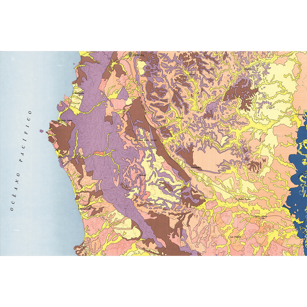
Jipijapa. Scale of 1:200 000. Date of publication: 1979.
1. Jipijapa : carta de paisajes vegetales y uso actual. / Gordillo, Luis; Muñoz F., Alfredo; Tipantuña A., Gustavo; Torre S., Patricio de la; Winckell, A.; Zebrowski, C.; Scale of 1:200 000. Date of publication: 1979. (file: 11247RC_IRD_ECU_USOL_1979_200000_IRD_ECU_CSRE_1979_200000.tif)
2. Jipijapa : carta de recursos de suelos. / Arévalo, Anibal; Benitez, Miguel E.; Vicariot, François; Scale of 1:200 000. Date of publication: 1979. (file: 11249RC_IRD_ECU_PEDO_1979_200000_IRD_ECU_CSRE_1979_200000.tif)
3. Jipijapa : carta de suelos. / Gordillo, Luis; Guevara, Oswaldo; Torres, Jaime; Torre S., Patricio de la; Zebrowski, C.; Scale of 1:200 000. Date of publication: 1979. (file: 11245RC_IRD_ECU_PEDO_1979_200000_IRD_ECU_CSRE_1979_200000.tif)
4. Jipijapa : carta de uso potencial. / Arévalo, Anibal; Benitez, Miguel E.; Vicariot, François; Scale of 1:200 000. Date of publication: 1979. (file: 11250RC_IRD_ECU_USOL_1979_200000_IRD_ECU_CSRE_1979_200000.tif)
5. Jipijapa : carta geomprfologica. / Almeida, Guillermo; Corvalan, Nicolas; Torre S., Patricio de la; Winckell, A.; Zavgorodnyaya, Svetlana; Scale of 1:200 000. Date of publication: 1979. (file: 11246RC_IRD_ECU_GMOR_1979_200000_IRD_ECU_CSRE_1979_200000.tif)
6. Jipijapa : utilizacion del agua disponible segun el modulo anual. / Cisneros, Marcelo; Cadier, Eric; Gomez, Gustavo; Paredes D., Luis; Pourrut, Pierre; Scale of 1:200 000. Date of publication: 1979. (file: 11251RC_IRD_ECU_USOL_1979_200000_IRD_ECU_CSRE_1979_200000.tif)
7. Jipijapa : zonas regables segun criterios fisico-climaticos. / Cisneros, Marcelo; Hidalgo C., Patricio; Pourrut, Pierre; Scale of 1:200 000. Date of publication: 1979. (file: 11248RC_IRD_ECU_CLIM_1979_200000_IRD_ECU_CSRE_1979_200000.tif)
Simple
- Date (Publication)
- 1979-01-01
- Citation identifier
- IRD_ECU_CSRE_1979_200000
- Credit
-
The region Île-de-France, under the project NumeriSud, supported the action to transforme around 2800 maps that are conserved at the Institut de recherche pour le développement (IRD) library in Bondy into a standard coordinate system. The transformation of the images has been done by Global Mapping Resources (South Africa) under the supervision of R. Zaiss (éditeur) 2014.
- Status
- Completed
- Point of contact
-
Organisation name Individual name Electronic mail address Role Institut de recherche pour le développement (IRD)
Production cartographique IRD
Point of contact Almeida, Guillermo
Author Arévalo, Anibal
Author Cisneros, Marcelo
Author Gordillo, Luis
Author Benitez, Miguel E.
Author Cadier, Eric
Author Corvalan, Nicolas
Author Gomez, Gustavo
Author Guevara, Oswaldo
Author Hidalgo C., Patricio
Author Muñoz F., Alfredo
Author Paredes D., Luis
Author Pourrut, Pierre
Author Tipantuña A., Gustavo
Author Torres, Jaime
Author Torre S., Patricio de la
Author Vicariot, François
Author Winckell, A.
Author Zavgorodnyaya, Svetlana
Author Zebrowski, C.
Author MAG, Ministerio de agricultura y ganaderia, PRONAREG. Programa nacional de regionalizacion agraria
editor ORSTOM, Office de la recherche scientifique et technique outre-mer
editor
- Maintenance and update frequency
- Not planned
-
Geounits
-
-
Americas
-
South America
-
Ecuador
-
- Theme
-
-
thematic map
-
- Keywords
-
-
project NumeriSud
-
map collection
-
local coverage
-
labex CEBA
-
- Use limitation
-
Licence : CC-BY-NC-SA
- Access constraints
- licence
- Classification
- Unclassified
- Spatial representation type
- Grid
- Denominator
- 200000
- Language
- Français
- Character set
- UTF8
- Topic category
-
- Climatology, meteorology, atmosphere
- Geoscientific information
- Planning cadastre
))
- Begin date
- 1979-01-01
- End date
- 1979-12-31
- Supplemental Information
-
Publication(s):
Arévalo, A., Vicariot, F., Benitez, M. E. (1979): Jipijapa : carta de recursos de suelos. Quito (ECU) : MAG, Ministerio de agricultura y ganaderia, PRONAREG. Programa nacional de regionalizacion agraria ; Quito (ECU) : ORSTOM, Office de la recherche scientifique et technique outre mer.
Benitez, M. E., Arévalo, A., Vicariot, F. (1979): Jipijapa : carta de uso potencial. Quito (ECU) : MAG, Ministerio de agricultura y ganaderia, PRONAREG. Programa nacional de regionalizacion agraria ; Quito (ECU) : ORSTOM, Office de la recherche scientifique et technique outre mer.
Muñoz, A., Tipantuña, A., G., Winckell, A., Zebrowski, C., Torre, P., Gordillo, L. (1979): Jipijapa : carta de paisajes vegetales y uso actual. Quito (ECU) : MAG, Ministerio de agricultura y ganaderia, PRONAREG. Programa nacional de regionalizacion agraria ; Quito (ECU) : ORSTOM, Office de la recherche scientifique et technique outre mer.
Pourrut, P., Hidalgo, P., Cisneros, M. (1979): Jipijapa : zonas regables segun criterios fisico-climaticos. Quito (ECU) : MAG, Ministerio de agricultura y ganaderia, PRONAREG. Programa nacional de regionalizacion agraria ; Quito (ECU) : ORSTOM, Office de la recherche scientifique et technique outre mer.
Pourrut, P., Parades, L., Cadier, E., Cisneros, M., Gomez, G. (1979): Jipijapa : utilizacion del agua disponible segun el modulo anual. Quito (ECU) : MAG, Ministerio de agricultura y ganaderia, PRONAREG. Programa nacional de regionalizacion agraria ; Quito (ECU) : ORSTOM, Office de la recherche scientifique et technique outre mer.
Winckell, A., Zavgorodnyaya, S., Corvalan, N., Torre, P., Almeida, L. (1979): Jipijapa : carta geomprfologica. Quito (ECU) : MAG, Ministerio de agricultura y ganaderia, PRONAREG. Programa nacional de regionalizacion agraria ; Quito (ECU) : ORSTOM, Office de la recherche scientifique et technique outre mer.
Zebrowski, C., Torres, J., Guevara, O., Torre, P., Gordillo, L. (1979): Jipijapa : carta de suelos. Quito (ECU) : MAG, Ministerio de agricultura y ganaderia, PRONAREG. Programa nacional de regionalizacion agraria ; Quito (ECU) : ORSTOM, Office de la recherche scientifique et technique outre mer.
- Reference system identifier
- EPSG / 4326 / 7.9
- Distribution format
-
Name Version GeoTIFF
1.0
- Distributor contact
-
Organisation name Individual name Electronic mail address Role DataSuds-geo
Publisher
- OnLine resource
-
Protocol Linkage Name OGC:WMS
https://datasuds-geo.ird.fr/geoserver/wms sphaera_ws:11247RC_IRD_ECU_USOL_1979_200000_IRD_ECU_CSRE_1979_200000
WWW:DOWNLOAD:GeoTIFF https://datasuds-geo.ird.fr/geoserver/ows?service=WCS&version=2.0.1&request=GetCoverage&coverageId=11247RC_IRD_ECU_USOL_1979_200000_IRD_ECU_CSRE_1979_200000
- OnLine resource
-
Protocol Linkage Name OGC:WMS
https://datasuds-geo.ird.fr/geoserver/wms sphaera_ws:11249RC_IRD_ECU_PEDO_1979_200000_IRD_ECU_CSRE_1979_200000
WWW:DOWNLOAD:GeoTIFF https://datasuds-geo.ird.fr/geoserver/ows?service=WCS&version=2.0.1&request=GetCoverage&coverageId=11249RC_IRD_ECU_PEDO_1979_200000_IRD_ECU_CSRE_1979_200000
- OnLine resource
-
Protocol Linkage Name OGC:WMS
https://datasuds-geo.ird.fr/geoserver/wms sphaera_ws:11245RC_IRD_ECU_PEDO_1979_200000_IRD_ECU_CSRE_1979_200000
WWW:DOWNLOAD:GeoTIFF https://datasuds-geo.ird.fr/geoserver/ows?service=WCS&version=2.0.1&request=GetCoverage&coverageId=11245RC_IRD_ECU_PEDO_1979_200000_IRD_ECU_CSRE_1979_200000
- OnLine resource
-
Protocol Linkage Name OGC:WMS
https://datasuds-geo.ird.fr/geoserver/wms sphaera_ws:11250RC_IRD_ECU_USOL_1979_200000_IRD_ECU_CSRE_1979_200000
WWW:DOWNLOAD:GeoTIFF https://datasuds-geo.ird.fr/geoserver/ows?service=WCS&version=2.0.1&request=GetCoverage&coverageId=11250RC_IRD_ECU_USOL_1979_200000_IRD_ECU_CSRE_1979_200000
- OnLine resource
-
Protocol Linkage Name OGC:WMS
https://datasuds-geo.ird.fr/geoserver/wms sphaera_ws:11246RC_IRD_ECU_GMOR_1979_200000_IRD_ECU_CSRE_1979_200000
WWW:DOWNLOAD:GeoTIFF https://datasuds-geo.ird.fr/geoserver/ows?service=WCS&version=2.0.1&request=GetCoverage&coverageId=11246RC_IRD_ECU_GMOR_1979_200000_IRD_ECU_CSRE_1979_200000
- OnLine resource
-
Protocol Linkage Name OGC:WMS
https://datasuds-geo.ird.fr/geoserver/wms sphaera_ws:11251RC_IRD_ECU_USOL_1979_200000_IRD_ECU_CSRE_1979_200000
WWW:DOWNLOAD:GeoTIFF https://datasuds-geo.ird.fr/geoserver/ows?service=WCS&version=2.0.1&request=GetCoverage&coverageId=11251RC_IRD_ECU_USOL_1979_200000_IRD_ECU_CSRE_1979_200000
- OnLine resource
-
Protocol Linkage Name OGC:WMS
https://datasuds-geo.ird.fr/geoserver/wms sphaera_ws:11248RC_IRD_ECU_CLIM_1979_200000_IRD_ECU_CSRE_1979_200000
WWW:DOWNLOAD:GeoTIFF https://datasuds-geo.ird.fr/geoserver/ows?service=WCS&version=2.0.1&request=GetCoverage&coverageId=11248RC_IRD_ECU_CLIM_1979_200000_IRD_ECU_CSRE_1979_200000
- OnLine resource
-
Protocol Linkage Name DOI
https://doi.org/10.23708/d8c0a743-7734-4b1b-9e33-96b4d8688668 Digital Object Identifier (DOI)
- Hierarchy level
- Dataset
- Statement
-
1. Scanning to tif format, 256 colors, 250dpi.
2. Georeferencing and if possible reprojection to WGS84 (Longitude / Latitude).
3. Clipping and mosaicing of map sheets(s).
4. Export ECW format.
5. ECW to GeoTIFF format conversion.
Metadata
- File identifier
- d8c0a743-7734-4b1b-9e33-96b4d8688668 XML
- Metadata language
- English
- Character set
- UTF8
- Hierarchy level
- Dataset
- Hierarchy level name
-
dataset
- Date stamp
- 2024-02-13T18:39:44.293808Z
- Metadata standard name
-
ISO 19115:2003/19139
- Metadata standard version
-
1.0
- Metadata author
-
Organisation name Individual name Electronic mail address Role Institut de recherche pour le développement (IRD)
Service de l'Information Scientifique et Technique (IST) IRD
Point of contact Institut de recherche pour le développement (IRD)
IRD
Resource provider
Overviews


Spatial extent
Provided by
