 Demo Catalogue powered by geOrchestra
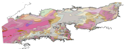
Map of surficial sediments in the English Channel (vector data)
Map of surficial sediments in the English Channel area known as "Larsonneur."
Simple
- Date (Publication)
- 1979-12-31T10:44:00
- Citation identifier
- FRE-330-715-368-00032-FormationsSup_Manche_Larsonneur_1979
- Presentation form
- Digital map
- Status
- On going
- Point of contact
-
Organisation name Individual name Electronic mail address Role Ifremer - Centre de Brest
Point of contact
- Maintenance and update frequency
- As needed
-
GEMET - INSPIRE themes, version 1.0
-
-
Geology
-
-
external.theme.gemet
-
-
seabed
-
marine sediment
-
- Theme
-
-
sedimentology
-
- Place
-
-
English Channel
-
- Discipline
-
-
geophysics
-
-
Thèmes Sextant
-
-
/Physical Environment/Sedimentology Geology/Seabed Nature
-
-
Sous-regions marines
-
-
/Metropolitan France/Channel-North Sea
-
/Metropolitan France/Celtic Seas
-
- Use limitation
-
No commercial use permitted. This data is reserved for research purposes only.
- Access constraints
- Copyright
- Spatial representation type
- Vector
- Denominator
- 500000
- Language
- Français
- Character set
- UTF8
- Topic category
-
- Geoscientific information
))
- Supplemental Information
-
Label codes legend:
CB1b : lithoclastic gravelly coquinite (sand and gravel)
CL1a : lithoclastic rubble
CL1b : lithoclastic gravelly rubble (sand and gravel)
CL2a : litho-bioclastic shelly rubble
CL2b : litho-bioclastic gravelly rubble (sand and gravel)
GB1a : bio-lithoclastic shelly gravel (stony)
GB1b : bio-lithoclastic gravel
GB2a : bioclastic shelly gravel
GB2b : bioclastic gravel
GL1a : lithoclastic stony gravel (shelly)
GL1b : lithoclastic gravel
GL2a : litho-bioclastic shelly or rubbly gravel
GL2b : litho-bioclastic gravel
SB1a : bio-lithoclastic Shelly sand (stony)
SB1b : bio-lithoclastic gravelly sand
SB1c : bio-lithoclastic course sand
SB1d : bio-lithoclastic fine sand
SB1e : bio-lithoclastic very fine sand
SB2a : bioclastic shelly sand
SB2b : bioclastic gravelly sand
SB2c : bioclastic coarse sand
SB2d : bioclastic fine sand
SB2e : bioclastic very fine sand
SL1a : lithoclastic rubbly sand (shelly)
SL1b : lithoclastic gravelly sand
SL1d : lithoclastic fine sand
SL1d-e: lithoclastic fine / very fine sand
SL1e : lithoclastic very fine sand
SL2a : litho-bioclastic gravelly or shelly sand
SL2b : lithoclastic bio-gravelly sand
SL2c : litho-bioclastic coarse sand
SL2d : litho-bioclastic fine sand
SL2e : litho-bioclastic very fine sand
VB1a : Sediment (sand) lithoclastic bio-mud (silt and clay)
VB2a : Sediment (sand) bioclastic mud (silt and clay)
VL1a : Sediment (sand) lithoclastic mud (silt and clay)
VL1b : Mud (silty clay) sand (gravel or rocky)
VL2a : Sediment (sand) litho-bioclastic mud (silt and clay)
VL2a : Sediment (sand) litho-bioclastic mud (silt and clay)
VL2b : Marne sand (gravelly or rocky) or shelly
- Reference system identifier
- EPSG / WGS 84 (EPSG:4326) / 7.4
- Topology level
- Geometry only
- Geometric object type
- Surface
- Geometric object count
- 1767
- Distributor contact
-
Organisation name Individual name Electronic mail address Role Ifremer - Centre de Brest
Distributor
- OnLine resource
-
Protocol Linkage Name OGC:WMS
https://sextant.ifremer.fr/services/wms/gm_geologie FormationsSup_Manche_Larsonneur_1979
FILE
FormationsSup_Manche_Larsonneur_1979
- Hierarchy level
- Dataset
Conformance result
- Date (Publication)
- 2007-03-14
- Explanation
-
Not evaluated
- Pass
- No
- Statement
-
Geological map of the continental margin
Metadata
- File identifier
- cc5a9b50-9d8a-11dc-8792-000086f6a62e XML
- Metadata language
- Français
- Character set
- UTF8
- Hierarchy level
- Dataset
- Date stamp
- 2024-04-05T08:07:59.864Z
- Metadata standard name
-
ISO 19115:2003/19139 - SEXTANT
- Metadata standard version
-
1.0
- Metadata author
-
Organisation name Individual name Electronic mail address Role Ifremer
Point of contact
- Other language
-
Language Character encoding English French UTF8
Overviews
Spatial extent
Provided by
