 Demo Catalogue powered by geOrchestra
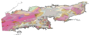
Carte des sédiments superficiels de la Manche (données vecteurs)
Map of surficial sediments in the English Channel (vector data)
Carte des sédiments superficiels de la Manche, dite "de Larsonneur".
Map of surficial sediments in the English Channel area known as "Larsonneur."
Simple
-
Date (Publication)Date (Publication)
- 1979-12-31T10:44:00
-
Citation identifierIdentificateur
- FRE-330-715-368-00032-FormationsSup_Manche_Larsonneur_1979
-
Presentation formForme de la présentation
-
Digital mapCarte numérique
-
StatusEtat
-
On goingMise à jour continue
- Point of contact
-
Organisation name Individual name Electronic mail address Role Ifremer - Centre de Brest
Point of contactPoint de contact
-
Maintenance and update frequencyFréquence de mise à jour
-
As neededLorsque nécessaire
-
GEMET - INSPIRE themes, version 1.0
-
-
Géologie
Geology
-
-
external.theme.gemet
-
-
fond marin
seabed
-
sédiment marin
marine sediment
-
-
ThemeThème
-
-
sédimentologie
sedimentology
-
-
PlaceLocalisation
-
-
Manche
English Channel
-
-
DisciplineDiscipline
-
-
géophysique
geophysics
-
-
Thèmes Sextant
-
-
/Milieu physique/Géologie sédimentologie/Nature des fonds
/Physical Environment/Sedimentology Geology/Seabed Nature
-
-
Sous-regions marines
-
-
/Métropole/Manche mer du Nord
/Metropolitan France/Channel-North Sea
-
/Métropole/Mers Celtiques
/Metropolitan France/Celtic Seas
-
-
Limitation d'utilisationUse limitation
-
Pas d'utilisation commerciale. Ces données sont réservées à des fins de recherche.
No commercial use permitted. This data is reserved for research purposes only.
-
Access constraintsContraintes d'accès
-
CopyrightDroit d’auteur / Droit moral (copyright)
-
Spatial representation typeType de représentation spatiale
-
VectorVecteur
-
DenominatorDénominateur de l'échelle
- 500000
-
LanguageLangue de la ressource
- Français
-
Character setEncodage des caractères
-
UTF8Utf8
-
Topic categoryCatégorie ISO
-
-
Geoscientific informationSciences de la terre, géosciences
-
))
-
Informations supplémentairesSupplemental Information
-
Libellés des codes de la légende :
CB1b : Coquinite lithoclastique graveleux (sablo-graveleux)
CL1a : Cailloutis lithoclastique
CL1b : Cailloutis lithoclastique graveleux (sablo-graveleux)
CL2a : Cailloutis litho-bioclastique coquillier
CL2b : Cailloutis litho-bioclastique graveleux (sablo-graveleux)
GB1a : Gravier bio-lithoclastique coquillier (caillouteux)
GB1b : Gravier bio-lithoclastique
GB2a : Gravier bioclastique coquillier
GB2b : Gravier bioclastique
GL1a : Gravier lithoclastique caillouteux (coquillier)
GL1b : Gravier lithoclastique
GL2a : Gravier litho-bioclastique coquillier ou caillouteux
GL2b : Gravier litho-bioclastique
SB1a : Sable bio-lithoclastique coquillier (caillouteux)
SB1b : Sable bio-lithoclastique graveleux
SB1c : Sable bio-lithoclastique grossier
SB1d : Sable bio-lithoclastique fin
SB1e : Sablon bio-lithoclastique
SB2a : Sable bioclastique coquillier
SB2b : Sable bioclastique graveleux
SB2c : Sable bioclastique grossier
SB2d : Sable bioclastique fin
SB2e : Sablon bioclastique
SL1a : Sable lithoclastique caillouteux (coquillier)
SL1b : Sable lithoclastique graveleux
SL1d : Sable lithoclastique fin
SL1d-e : Sable lithoclastique fin / Sablon lithoclastique
SL1e : Sablon lithoclastique
SL2a : Sable litho-bioclastique caillouteux ou coquillier
SL2b : Sable lithoclastique bio-gravelaux
SL2c : Sable litho-bioclastique grossier
SL2d : Sable litho-bioclastique fin
SL2e : Sablon litho-bioclastique
VB1a : Sédiment (sable) bio-lithoclastique vaseux (silto-argileux)
VB2a : Sédiment (sable) bioclastique vaseux (silto-argileux)
VL1a : Sédiment (sable) lithoclastique vaseux (silto-argileux)
VL1b : Vase (silto-argileuse) sableuse (graveleuse ou caillouteuse)
VL2a : Sédiment (sable) litho-bioclastique vaseux (silto-argileux)
VL2a : Sédiment (sable) litho-bioclastique vaseux (silto-argileux)
VL2b : Marne sableuse ( graveleuse ou caillouteuse) ou coquillier
Label codes legend:
CB1b : lithoclastic gravelly coquinite (sand and gravel)
CL1a : lithoclastic rubble
CL1b : lithoclastic gravelly rubble (sand and gravel)
CL2a : litho-bioclastic shelly rubble
CL2b : litho-bioclastic gravelly rubble (sand and gravel)
GB1a : bio-lithoclastic shelly gravel (stony)
GB1b : bio-lithoclastic gravel
GB2a : bioclastic shelly gravel
GB2b : bioclastic gravel
GL1a : lithoclastic stony gravel (shelly)
GL1b : lithoclastic gravel
GL2a : litho-bioclastic shelly or rubbly gravel
GL2b : litho-bioclastic gravel
SB1a : bio-lithoclastic Shelly sand (stony)
SB1b : bio-lithoclastic gravelly sand
SB1c : bio-lithoclastic course sand
SB1d : bio-lithoclastic fine sand
SB1e : bio-lithoclastic very fine sand
SB2a : bioclastic shelly sand
SB2b : bioclastic gravelly sand
SB2c : bioclastic coarse sand
SB2d : bioclastic fine sand
SB2e : bioclastic very fine sand
SL1a : lithoclastic rubbly sand (shelly)
SL1b : lithoclastic gravelly sand
SL1d : lithoclastic fine sand
SL1d-e: lithoclastic fine / very fine sand
SL1e : lithoclastic very fine sand
SL2a : litho-bioclastic gravelly or shelly sand
SL2b : lithoclastic bio-gravelly sand
SL2c : litho-bioclastic coarse sand
SL2d : litho-bioclastic fine sand
SL2e : litho-bioclastic very fine sand
VB1a : Sediment (sand) lithoclastic bio-mud (silt and clay)
VB2a : Sediment (sand) bioclastic mud (silt and clay)
VL1a : Sediment (sand) lithoclastic mud (silt and clay)
VL1b : Mud (silty clay) sand (gravel or rocky)
VL2a : Sediment (sand) litho-bioclastic mud (silt and clay)
VL2a : Sediment (sand) litho-bioclastic mud (silt and clay)
VL2b : Marne sand (gravelly or rocky) or shelly
-
Reference system identifierNom du système de référence
-
EPSG
/
WGS 84 (EPSG:4326)/ 7.4
-
Topology levelNiveau topologie
-
Geometry onlyGéométrie seulement
-
Geometric object typeType de géométries des objets
-
SurfacePolygone
-
Geometric object countNombre d'objets géométriques
- 1767
- Distributor contact
-
Organisation name Individual name Electronic mail address Role Ifremer - Centre de Brest
DistributorDistributeur
- OnLine resource
-
Protocol Linkage Name OGC:WMS
https://sextant.ifremer.fr/services/wms/gm_geologie FormationsSup_Manche_Larsonneur_1979
FILE
FormationsSup_Manche_Larsonneur_1979
-
Hierarchy levelNiveau
-
DatasetJeu de données
Conformance result
Résultat de conformité
-
Date (Publication)Date (Publication)
- 2007-03-14
-
ExplicationExplanation
-
Non évalué
Not evaluated
-
PassDegré de conformité
- No
-
Généralités sur la provenanceStatement
-
Carte géologique de la marge continentale
Geological map of the continental margin
Metadata
-
File identifierIdentifiant de la fiche
- cc5a9b50-9d8a-11dc-8792-000086f6a62e XML
-
Metadata languageLangue
- Français
-
Character setJeu de caractères
-
UTF8Utf8
-
Hierarchy levelType de ressource
-
DatasetJeu de données
-
Date stampDate des métadonnées
- 2024-04-05T08:07:59.864Z
- Metadata standard name
-
ISO 19115:2003/19139 - SEXTANT
- Metadata standard version
-
1.0
- Metadata author
-
Organisation name Individual name Electronic mail address Role Ifremer
Point of contactPoint de contact
- Other language
-
Language Character encoding EnglishAnglaisFrenchFrançaisUTF8Utf8
Overviews
Spatial extent
Provided by
