 Demo Catalogue powered by geOrchestra
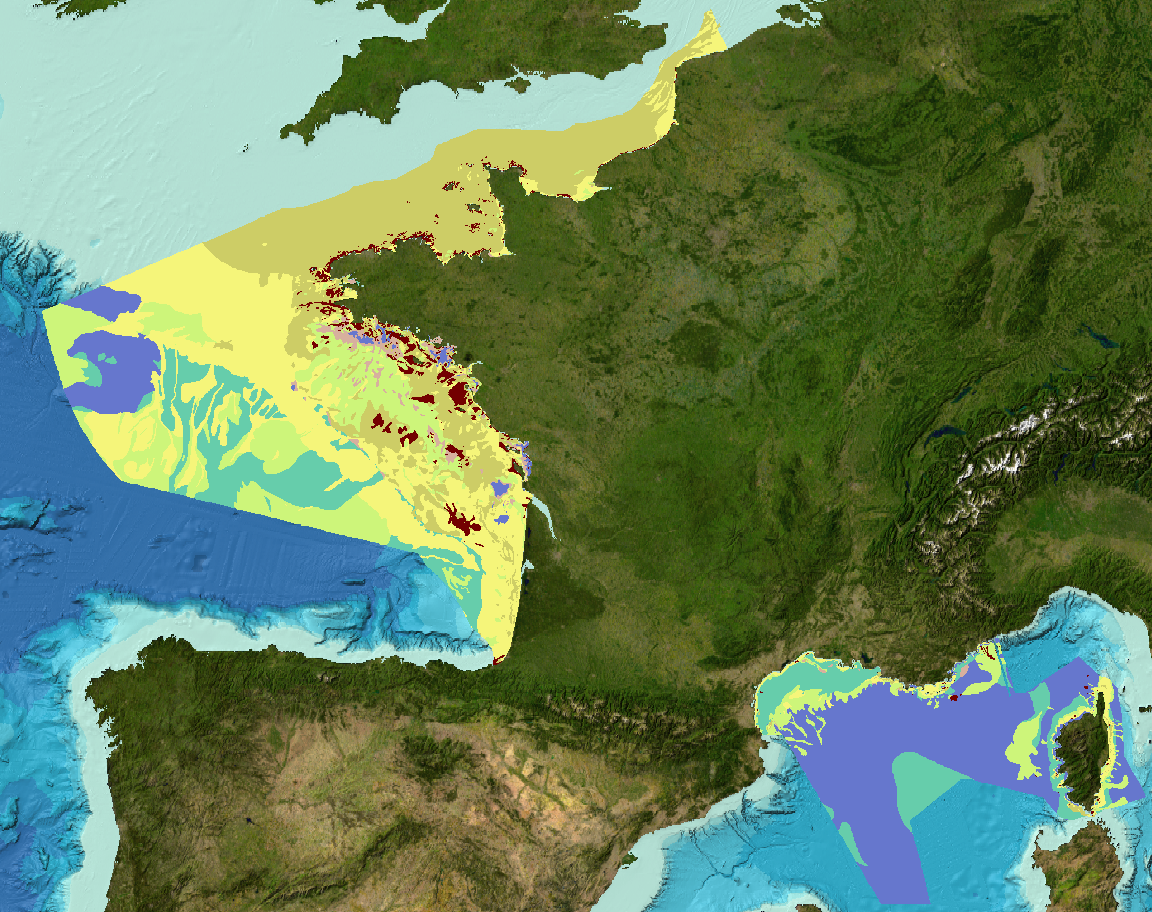
EMODNet Geology - Formations superficielles de la ZEE métropolitaine française
EMODNet Geology - Sediment substrate maps of the French metropolitan EEZ
Cartes des formations superficielles à différentes échelles, produites par la France dans le cadre du work-package 3 du projet européen EMODNet Geology (phase IV), à l'intérieur de la ZEE métropolitaine française.
Echelles disponibles :
- 1 : 1 000 000
- 1 : 250 000
- 1 : 100 000
- 1 : 50 000
- 1 : 20 000
- 1 : 15 000
- 1 : 10 000
- 1 : 5 000
Références bibliographiques :
- Coltman, N., Gilliland, P. & van Heteren, S. 2007. What can I do with my map? In: MESH Guide to Habitat Mapping, MESH Project, 2007, JNCC, Peterborough. Available online at:
( http://www.searchmesh.net/default.aspx?page=1900)
- Foster-Smith, R., Connor, D. & Davies, J. 2007. What is habitat mapping? In: MESH Guide to Habitat Mapping, MESH Project, 2007, JNCC, Peterborough. Available
online at: ( http://www.searchmesh.net/default.aspx?page=1900)
- Väänänen, T. (ed), Hyvönen, E., Jakonen, M., Kupila, J., Lerrsi, J., Leskinen, J., Liwata, P., Nevalainen, R., Putkinen, S., Virkki, H. 2007. Maaperän yleiskartan tulkinta- ja kartoitusprosessi. Maaperän yleiskartoitus –hankkeen sisäinen raportti. 17 p.
Sediment substrate maps at different scales, of the French metropolitan EEZ produced in the work-package 3 the European project EMODNet Geology (phase IV).
Available scales :
- 1 : 1 000 000
- 1 : 250 000
- 1 : 100 000
- 1 : 50 000
- 1 : 20 000
- 1 : 15 000
- 1 : 10 000
- 1 : 5 000
Bibliographic references :
- Coltman, N., Gilliland, P. & van Heteren, S. 2007. What can I do with my map? In: MESH Guide to Habitat Mapping, MESH Project, 2007, JNCC, Peterborough. Available online at:
( http://www.searchmesh.net/default.aspx?page=1900)
- Foster-Smith, R., Connor, D. & Davies, J. 2007. What is habitat mapping? In: MESH Guide to Habitat Mapping, MESH Project, 2007, JNCC, Peterborough. Available
online at: ( http://www.searchmesh.net/default.aspx?page=1900)
- Väänänen, T. (ed), Hyvönen, E., Jakonen, M., Kupila, J., Lerrsi, J., Leskinen, J., Liwata, P., Nevalainen, R., Putkinen, S., Virkki, H. 2007. Maaperän yleiskartan tulkinta- ja kartoitusprosessi. Maaperän yleiskartoitus –hankkeen sisäinen raportti. 17 p.
Simple
-
Date (Publication)Date (Publication)
- 2017-04-14
-
Date (Revision)Date (Révision)
- 2024-05-17
-
Citation identifierIdentificateur
- EMODNET_WP3_SeabedSubstrate_1M_2023
-
ReconnaissanceCredit
-
Ifremer, BRGM, SHOM, Université de Bordeaux 1
Ifremer, BRGM, SHOM, Université de Bordeaux 1
- Point of contact
-
Organisation name Individual name Electronic mail address Role Ifremer
Ifremer Geo-Ocean
AuthorAuteurIfremer
Simplet Laure
AuthorAuteurEuropean Commission
EMODNet Geology
PublisherEditeur (publication)
-
Thèmes Sextant
-
-
/Milieu physique/Géologie
/Physical Environment/Geology
-
-
GEMET - INSPIRE themes, version 1.0
-
-
Géologie
Geology
-
-
DisciplineDiscipline
-
-
Sédimentologie
Sedimentology
-
-
Sous-regions marines
-
-
/Métropole
/Metropolitan France
-
-
Thématiques - SIMM
-
-
Recherche
Research
-
/Etat du Milieu/Géologie
/Environmental Status/Geology
-
-
Limitation d'utilisationUse limitation
-
CC-BY (Creative Commons - Attribution)CC-BY (Creative Commons - Attribution)
-
Access constraintsContraintes d'accès
-
LicenseLicence
-
Use constraintsContraintes d'utilisation
-
Other restrictionsAutres restrictions
-
Autres contraintesOther constraints
-
Pas de restriction d'accès public
No public access restrictions
-
Autres contraintes
-
Citation : European Commission – EMODNet Geology
-
Spatial representation typeType de représentation spatiale
-
VectorVecteur
-
DenominatorDénominateur de l'échelle
- 1000000
-
DenominatorDénominateur de l'échelle
- 250000
-
DenominatorDénominateur de l'échelle
- 100000
-
DenominatorDénominateur de l'échelle
- 50000
-
DenominatorDénominateur de l'échelle
- 20000
-
DenominatorDénominateur de l'échelle
- 15000
-
DenominatorDénominateur de l'échelle
- 10000
-
DenominatorDénominateur de l'échelle
- 5000
-
LanguageLangue de la ressource
- Français
-
Character setEncodage des caractères
-
UTF8Utf8
-
Topic categoryCatégorie ISO
-
-
OceansOcéans
-
))
-
Reference system identifierNom du système de référence
-
EPSG
/
WGS 84 (EPSG:4326)/ 8.6
-
Geometric object typeType de géométries des objets
-
SurfacePolygone
- Distribution format
-
Name Version ESRI Shapefile
1.0
- OnLine resource
-
Protocol Linkage Name WWW:LINK
http://www.emodnet.eu/geology EMODNet Geology
- OnLine resource
-
Protocol Linkage Name NETWORK:LINK
_REFERENTIELS\GEOLOGIE\FranceMetropole_EMODnetGeology\EMODnet_WP3_Sediments EMODnet_WP3_Sediments
- OnLine resource
-
Protocol Linkage Name OGC:WMS
https://sextant.ifremer.fr/services/wms/gm_geologie EMODNET_WP3_SeabedSubstrate_1M_2023
- OnLine resource
-
Protocol Linkage Name OGC:WMS
https://sextant.ifremer.fr/services/wms/gm_geologie EMODNET_WP3_SeabedSubstrate_250k_2023
- OnLine resource
-
Protocol Linkage Name OGC:WMS
https://sextant.ifremer.fr/services/wms/gm_geologie EMODNET_WP3_SeabedSubstrate_100k_2023
- OnLine resource
-
Protocol Linkage Name OGC:WMS
https://sextant.ifremer.fr/services/wms/gm_geologie EMODNET_WP3_SeabedSubstrate_50k_2023
- OnLine resource
-
Protocol Linkage Name OGC:WMS
https://sextant.ifremer.fr/services/wms/gm_geologie EMODNET_WP3_SeabedSubstrate_20k_2023
- OnLine resource
-
Protocol Linkage Name OGC:WMS
https://sextant.ifremer.fr/services/wms/gm_geologie EMODNET_WP3_SeabedSubstrate_15k_2023
OGC:WMS
https://sextant.ifremer.fr/services/wms/gm_geologie EMODNET_WP3_SeabedSubstrate_10k_2023
- OnLine resource
-
Protocol Linkage Name OGC:WMS
https://sextant.ifremer.fr/services/wms/gm_geologie EMODNET_WP3_SeabedSubstrate_5k_2023
- OnLine resource
-
Protocol Linkage Name COPYFILE
EMODnet_WP3_Sediments
-
Hierarchy levelNiveau
-
DatasetJeu de données
-
Généralités sur la provenanceStatement
-
Ces jeux de données sont basés sur la compilation des données libres existantes, et mises à disposition du projet EMODnet.
Les jeux de données à l'échelle 1 : 1 000 000 et 1 : 250 000 ont été réalisés selon une méthodologie d'harmonisation et de généralisation des cartes originales définie par les leaders (GTK, service géologique finlandais) du work-package 3 du lot Geology du projet européen EMODnet sur la base des travaux de Väänänen et al. (2007).
Les autres jeux de données, à des échelles plus grandes, n'ont pas été harmonisés selon cette méthodologie.
La classification sédimentaire retenue est celle de Folk, 1954. Selon 5, 7 ou 16 classes.
La table attributaire contient les informations suivantes :
- Code : Identifiant unique de la carte, composé du code du pays selon la norme ISO3166-code ( http://www.iso.org/iso/english_country_names_and_code_elements), et de trois chiffres.
- Country : pays producteur du jeu de données.
- Name : titre du jeu de données.
- DataHolder : organisme propriétaire du jeu de données.
- Contact : point de contact (courriel) pour accéder à la carte ou des informations sur celle-ci.
- Original_S(cale) : échelle de la carte d'origine.
- Original_G(rain_Size) : système de classification sédimentaire de la carte d'origine.
- MappingMet(hod) : méthode de création de la carte. 1 : modélisé, supervisé. 2 : modélisé, non supervisé. 3 : interprété manuellement. 4 : autre.
- References : référence bibliographique de la carte
- Comments : commentaire
- Reclassifi : 1 = reclassification basée sur des échantillons, 2 = reclassification estimée par expertise, 3 = reclassification basée sur des échantillons et estimée par expertise, 4 = pas de reclassification nécessaire, 0 = pas d'information.
- Method : méthodologie de cartographie après reclassification. 1 = interpolation automatique d'échantillons reclassifiés, 2 = interpolation automatique d'échantillons reclassifiés et de levés acoustiques et sismiques, 3 = reclassification de catégories de sédiments existantes, basée sur l'analyse d'échantillons, 4 = reclassification de catégories de sédiments existantes, estimée par expertise, 5 = pas d'ajustement nécessaire pour correspondre aux produits EMODnet, 0 = pas d'information.
- Sample_num : nombre minimum approximatif d'échantillons utilisés pour la classification de la carte originale
- Original_1 (Original_substrate) : nom du faciès sédimentaire de la carte originale
- Relation : ce code décrit le lien de conversion existant entre la classification originale et celle de Folk : 1 = le faciès d'origine est le même que Folk, 2 = le faciès d'origine est à peu près le même que Folk, 3 = Folk est inclus dans le faciès d'origine, 4 = le faciès d'origine est inclus dans Folk, 5 = le faciès d'origine couvre à peu près Folk, 6 = pas d'information
- Folk_16cl : code du faciès selon la classification de Folk, 16 classes
- Folk_16cl_ : nom du faciès selon la classification de Folk, 16 classes
- Folk_7cl : code du faciès selon la classification de Folk, 7 classes
- Folk_7cl_ : nom du faciès selon la classification de Folk, 7 classes
- Folk_5cl : code du faciès selon la classification de Folk, 5 classes
- Folk_5cl_ : nom du faciès selon la classification de Folk, 5 classes
- Surface_Fe(ature) : type de caractéristique géologique de la surface du fond marin.
- Surface__1 (Surface_Fe_Gr) : surface feature group. 1. Hard clay 2. Fe-Mn concretion field 3. Biological features 4. Seagrass meadows and seaweed communities 5. Seagrass meadows 6. Anthropogenic 7. Bedrock 8. Biogenic reef 9. Shell deposits 10. Maerl deposit 11. Bioclastic 12. Mixture: Two or more listed features 13. Gas-bearing sediment 14. Pockmarks 15. Moving sediment 16. Till 17. Landslide deposit 18. Thin erosional sand/coarse sediment 19. Glaciofluvial gravel&sand 20. Boulders 21. Patchy seafloor 22. Peat 23. Organic 24. Recent/Modern soft sediment 25. Lag deposits 26. Lithoclastic sediment 27. Unclassified
- Conf_RS : RS = Remote sensing. note attribuée au critère sur la couverture en imagerie acoustique. 0 = pas de données d'imagerie acoustique, 1 = couverture du levé <90% ; 2 = couverture du levé >90%
- Conf_S : Amount of sampling. 1 = chaque classe ou polygone est échantillonné ; 0 = toutes les classes ou tous les polygones ne sont pas échantillonnés
- Conf_D : Distinctness. 1 = les limites entre faciès acoustiques sont bien distinctes ; 0 = les limites entre faciès acoustiques ne sont pas distinctes
- Conf_TOT : note de fiabilité attribuée sur la base de CONF_TOT= RS+S+D
These datasets are based on a compilation of data made available with free access for the project EMODnet.
The 1:1,000,000 and 1:250,000 scale datasets were produced according to a methodology for harmonizing and generalizing the original maps defined by the leaders (GTK, Finnish Geological Survey) of work-package 3 of the Geology batch of the European EMODnet project, based on the work of Väänänen et al. (2007).
Other, larger-scale datasets have not been harmonized using this methodology.
Sediment classification adopted is Folk, 1954 according 5, 7 or 16 classes.
The attribute table contains the following informations:
- Code : Code refers to maps/datasets, which are congruent by scale and mapping technology or have been published as an entity. Code includes a two-letter country code, which corresponds to ISO3166- code, plus 3 digits (numbers) that identify each map.
- Country : The country where the data originates.
- Name : Original title of the map
- DataHolder : Abbreviation of the organization/institute holding the map.
- Contact : email of the contact to get access or information about data
- Original_S(cale) : original map's scale
- Original_G(rain_Size) : grain-size classification system used in the original map
- MappingMet(hod) : How the original map was created. 1= Modelled, supervised 2.= Modelled, unsupervised 3 = Manually interpreted 4 = Other
- References. : bibliographical reference
- Comments : Comments or other information regarding the dataset
- Reclassifi : 1 = Sample-based reclassification, 2 = Expert-based prediction reclassification, 3 = Sample- and Expert-based reclassification, 4 = No reclassification needed, 0 = No info.
- Method : mapping method. 1 = Automatic interpolation of reclassified samples, 2 = Automatic interpolation of reclassified samples and acoustic-seismic-surveys, 3 = Reclassification of existing substrate categories on the grounds of analysed surface samples, 4 = Reclassification of existing substrate categories on the grounds of expert-based predicted, surface material, 5 = The original dataset is EMODnet compatible and no adjustments have been done, 0 = No info
- Sample_num : Approximate the minimum number of samples used per original substrate category.
- Original_1 (Original_substrate) : name of the original/National substrate category.
- Relation : code describes the relationship between original classification versus Folk classification : 1 = original substrate is same as Folk, 2 = original substrate is nearly the same as Folk, 3 = Folk is contained within original substrate, 4 = original_substrate is contained within Folk, 5 = original_substrate partially overlaps with Folk, 6 = no info
- Folk_16cl : facies code according to the Folk classification, 16 classes
- Folk_16cl_ : facies name according to the Folk classification, 16 classes
- Folk_7cl : facies code according to the Folk classification, 7 classes
- Folk_7cl_ : facies name according to the Folk classification, 7 classes
- Folk_5cl : facies code according to the Folk classification, 5 classes
- Folk_5cl_ : facies name according to the Folk classification, 5 classes
- Surface_Fe(ature) : geological seabed surface feature type e.g. Biogenic material, Hard clay, Till, Fe-Mn concretion field, Shell areas.
- Surface__1 (Surface_Fe_Gr) : surface feature group. 1. Hard clay 2. Fe-Mn concretion field 3. Biological features 4. Seagrass meadows and seaweed communities 5. Seagrass meadows 6. Anthropogenic 7. Bedrock 8. Biogenic reef 9. Shell deposits 10. Maerl deposit 11. Bioclastic 12. Mixture: Two or more listed features 13. Gas-bearing sediment 14. Pockmarks 15. Moving sediment 16. Till 17. Landslide deposit 18. Thin erosional sand/coarse sediment 19. Glaciofluvial gravel&sand 20. Boulders 21. Patchy seafloor 22. Peat 23. Organic 24. Recent/Modern soft sediment 25. Lag deposits 26. Lithoclastic sediment 27. Unclassified
- Conf_RS : RS = "Remote sensing". Score attributed for backscatter coverage. 0= No backscatter data, 1= backscatter coverage is moderate or poor (<90%) ; 2= backscatter coverage is good (up to 90%).
- Conf_S : Amount of samples. 1 = every class/polygon was sampled ; 0 = not every class/polygon was sampled
- Conf_D : Distinctness of class boundaries. 1 = predicted class boundaries are distinct ; 0 = predicted class boundaries are less distinct
- Conf_TOT : Score for confidence calculated as CONF_TOT= RS+S+D
Metadata
-
File identifierIdentifiant de la fiche
- c540dc17-299b-470a-b71c-fa9934c93847 XML
-
Metadata languageLangue
- Français
-
Character setJeu de caractères
-
UTF8Utf8
-
Hierarchy levelType de ressource
-
DatasetJeu de données
-
Date stampDate des métadonnées
- 2024-05-22T12:43:39.132Z
- Metadata standard name
-
ISO 19115:2003/19139 - SEXTANT
- Metadata standard version
-
1.0
- Metadata author
-
Organisation name Individual name Electronic mail address Role Ifremer
Simplet Laure
Point of contactPoint de contact
- Other language
-
Language Character encoding EnglishAnglaisUTF8Utf8FrenchFrançaisUTF8Utf8
Overviews
Spatial extent
)))
Provided by
