• Demo Catalogue powered by geOrchestra
  •   Search
  •   Map

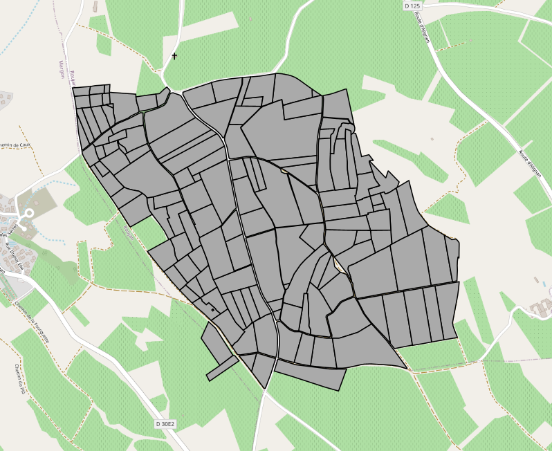
Parcellaires culturaux du bassin versant de Roujan.

Ce jeu de données renseigne sur les limites spatiales des parcelles culturales (unités de gestion agronomique) et leur évolution (fusion, remembrement, découpage) depuis la mise en place de l’observatoire OMERE ( https://www.obs-omere.org/ ).

Il est utile, associé à la base de données des états de surface (EDS) qui attribue, pour chaque parcelle culturale et à chaque date, ses principales caractéristiques liées à son fonctionnement hydrique.


Avant le 19 octobre 2004, les parcellaires ont été établis par Christian Floure, sur la base des relevés des EDS réalisés par François Garnier et Jean-Luc Belotti.

A partir du 19 octobre 2004, le parcellaire a été établi sur la base des relevés des EDS réalisés par Jean-Luc Belotti et David Fages dans le cadre de l’observatoire OMERE. Il est le reflet des parcelles suivies lors de chaque campagne terrain, et à ce titre, peut être incomplet pour une date donnée.


Les parcellaires sont nommés de la manière suivante {Date de releve sous forme Année-Mois-Jour}_{Code du site : ici ROU pour Roujan}_{PAR pour parcellaire}.


Chaque parcellaire possède au moins dans sa table attributaire une colonne NO_PARC qui correspond à un identifiant unique par parcelle culturale, dérivé de l’identifiant cadastral (Exemple : deux parcelles cadastrales aw 84 et aw 85 fusionnées en une parcelle culturale aura l’identifiant aw 84-85), une colonne AREA correspond à l’aire de la parcelle (en m²) et une colonne PERIMETER correspondant à la surface de la parcelle (en m).

Simple

Date (Creation)
2013-04-02
Date (Revision)
2015-03-20
Date (Publication)
2013-04-02
Code
10.23708/c41025f7-085f-41c8-948d-0faf110fb816
Status
On going
Point of contact
Organisation name Individual name Electronic mail address Role

UMR LISAH - INRAE, IRD, Institut Agro Montpellier, AgroParisTech

UMR LISAH - INRAE, IRD, Institut Agro Montpellier, AgroParisTech(Réf. : https://scanr.enseignementsup-recherche.gouv.fr/entite/197217858M )

Resource provider

UMR LISAH - INRAE, IRD, Institut Agro Montpellier, AgroParisTech

Pôle SI

umr-lisah-data@supagro.fr

Custodian

UMR LISAH - INRAE, IRD, Institut Agro Montpellier, AgroParisTech

Fabrice Vinatier

fabrice.vinatier@inrae.fr

Author

UMR LISAH - INRAE, IRD, Institut Agro Montpellier, AgroParisTech

Jean-Luc Belotti

jean-luc.belotti@inrae.fr

Author

UMR LISAH - INRAE, IRD, Institut Agro Montpellier, AgroParisTech

David Fages

david.fages@inrae.fr

Author

UMR LISAH - INRAE, IRD, Institut Agro Montpellier, AgroParisTech

Guillaume Coulouma

guillaume.coulouma@inrae.fr

Author
Maintenance and update frequency
As needed
Thésaurus INRAE
  • Bassin versant
  • Parcelle cultivée
  • Occupation du sol
  • Pratique culturale
  • Culture agricole
  • Exploitant agricole
AGROVOC Multilingual Thesaurus
  • Registre cadastral
Geonames
  • Roujan
  • Occitanie
  • France
Keywords
  • Parcellaire cultural

  • Propriétaire

  • Observatoire OMERE

Access constraints
Restricted
Use constraints
License
Other constraints

CC BY 4.0

https://creativecommons.org/licenses/by/4.0/

Spatial representation type
Vector
Distance
5  metres
Denominator
5000
Language

fre

Topic category
  • Environment
  • Farming
Description

Roujan

N
S
E
W
thumbnail


Begin date
1997-07-25
End date
2022-01-26
Supplemental Information

UMR LISAH

Unique resource identifier
RGF93 / Lambert93 (EPSG 2154 : https://www.opengis.net/def/crs/EPSG/9.9.1/2154)
Geometric object type
Surface
Distribution format
Name Version

GeoPackage (.gpkg)

Distributor contact
Organisation name Individual name Electronic mail address Role

DataSuds-geo

Publisher
OnLine resource
Protocol Linkage Name
WWW:LINK-1.0-http--link https://hal.inrae.fr/hal-02950747

« OMERE: A Long-Term Observatory of Soil and Water Resources, in Interaction with Agricultural and Land Management in Mediterranean Hilly Catchments ». Vadose Zone Journal 17 (1).

WWW:LINK-1.0-http--link https://doi.org/10.1016/j.apgeog.2017.12.003

« Using high-resolution multitemporal imagery to highlight severe land management changes in Mediterranean vineyards ». Applied Geography 90:115‑22.

OGC:WMS

https://datasuds-geo.ird.fr/geoserver/lisah_ws/ows?service=WMS

19970725_ROU_PAR

OGC:WMS

https://datasuds-geo.ird.fr/geoserver/lisah_ws/ows?service=WMS

20020624_ROU_PAR

OGC:WMS

https://datasuds-geo.ird.fr/geoserver/lisah_ws/ows?service=WMS

20021216_ROU_PAR

OGC:WMS

https://datasuds-geo.ird.fr/geoserver/lisah_ws/ows?service=WMS

20030325_ROU_PAR

OGC:WMS

https://datasuds-geo.ird.fr/geoserver/lisah_ws/ows?service=WMS

20030519_ROU_PAR

OGC:WMS

https://datasuds-geo.ird.fr/geoserver/lisah_ws/ows?service=WMS

20040224_ROU_PAR

OGC:WMS

https://datasuds-geo.ird.fr/geoserver/lisah_ws/ows?service=WMS

20041019_ROU_PAR

OGC:WMS

https://datasuds-geo.ird.fr/geoserver/lisah_ws/ows?service=WMS

20050608_ROU_PAR

OGC:WMS

https://datasuds-geo.ird.fr/geoserver/lisah_ws/ows?service=WMS

20080303_ROU_PAR

OGC:WMS

https://datasuds-geo.ird.fr/geoserver/lisah_ws/ows?service=WMS

20090310_ROU_PAR

OGC:WMS

https://datasuds-geo.ird.fr/geoserver/lisah_ws/ows?service=WMS

20090522_ROU_PAR

OGC:WMS

https://datasuds-geo.ird.fr/geoserver/lisah_ws/ows?service=WMS

20100421_ROU_PAR

OGC:WMS

https://datasuds-geo.ird.fr/geoserver/lisah_ws/ows?service=WMS

20100617_ROU_PAR

OGC:WMS

https://datasuds-geo.ird.fr/geoserver/lisah_ws/ows?service=WMS

20120116_ROU_PAR

OGC:WMS

https://datasuds-geo.ird.fr/geoserver/lisah_ws/ows?service=WMS

20120319_ROU_PAR

OGC:WMS

https://datasuds-geo.ird.fr/geoserver/lisah_ws/ows?service=WMS

20120503_ROU_PAR

OGC:WMS

https://datasuds-geo.ird.fr/geoserver/lisah_ws/ows?service=WMS

20120731_ROU_PAR

OGC:WMS

https://datasuds-geo.ird.fr/geoserver/lisah_ws/ows?service=WMS

20120830_ROU_PAR

OGC:WMS

https://datasuds-geo.ird.fr/geoserver/lisah_ws/ows?service=WMS

20120918_ROU_PAR

OGC:WMS

https://datasuds-geo.ird.fr/geoserver/lisah_ws/ows?service=WMS

20121211_ROU_PAR

OGC:WMS

https://datasuds-geo.ird.fr/geoserver/lisah_ws/ows?service=WMS

20130606_ROU_PAR

OGC:WMS

https://datasuds-geo.ird.fr/geoserver/lisah_ws/ows?service=WMS

20160614_ROU_PAR

OGC:WMS

https://datasuds-geo.ird.fr/geoserver/lisah_ws/ows?service=WMS

20160708_ROU_PAR

OGC:WMS

https://datasuds-geo.ird.fr/geoserver/lisah_ws/ows?service=WMS

20170524_ROU_PAR

OGC:WMS

https://datasuds-geo.ird.fr/geoserver/lisah_ws/ows?service=WMS

20180105_ROU_PAR

OGC:WMS

https://datasuds-geo.ird.fr/geoserver/lisah_ws/ows?service=WMS

20190510_ROU_PAR

OGC:WMS

https://datasuds-geo.ird.fr/geoserver/lisah_ws/ows?service=WMS

20200129_ROU_PAR

OGC:WMS

https://datasuds-geo.ird.fr/geoserver/lisah_ws/ows?service=WMS

20220126_ROU_PAR

WWW:DOWNLOAD-1.0-http--download https://datasuds-geo.ird.fr/geoserver/lisah_ws/ows?service=WFS&version=1.0.0&request=GetFeature&typeName=lisah_ws%3A19970725_ROU_PAR&outputFormat=application%2Fx-gpkg

19970725_ROU_PAR

WWW:DOWNLOAD-1.0-http--download https://datasuds-geo.ird.fr/geoserver/lisah_ws/ows?service=WFS&version=1.0.0&request=GetFeature&typeName=lisah_ws%3A20020624_ROU_PAR&outputFormat=application%2Fx-gpkg

20020624_ROU_PAR

WWW:DOWNLOAD-1.0-http--download https://datasuds-geo.ird.fr/geoserver/lisah_ws/ows?service=WFS&version=1.0.0&request=GetFeature&typeName=lisah_ws%3A20021216_ROU_PAR&outputFormat=application%2Fx-gpkg

20021216_ROU_PAR

WWW:DOWNLOAD-1.0-http--download https://datasuds-geo.ird.fr/geoserver/lisah_ws/ows?service=WFS&version=1.0.0&request=GetFeature&typeName=lisah_ws%3A20030325_ROU_PAR&outputFormat=application%2Fx-gpkg

20030325_ROU_PAR

WWW:DOWNLOAD-1.0-http--download https://datasuds-geo.ird.fr/geoserver/lisah_ws/ows?service=WFS&version=1.0.0&request=GetFeature&typeName=lisah_ws%3A20030519_ROU_PAR&outputFormat=application%2Fx-gpkg

20030519_ROU_PAR

WWW:DOWNLOAD-1.0-http--download https://datasuds-geo.ird.fr/geoserver/lisah_ws/ows?service=WFS&version=1.0.0&request=GetFeature&typeName=lisah_ws%3A20040224_ROU_PAR&outputFormat=application%2Fx-gpkg

20040224_ROU_PAR

WWW:DOWNLOAD-1.0-http--download https://datasuds-geo.ird.fr/geoserver/lisah_ws/ows?service=WFS&version=1.0.0&request=GetFeature&typeName=lisah_ws%3A20041019_ROU_PAR&outputFormat=application%2Fx-gpkg

20041019_ROU_PAR

WWW:DOWNLOAD-1.0-http--download https://datasuds-geo.ird.fr/geoserver/lisah_ws/ows?service=WFS&version=1.0.0&request=GetFeature&typeName=lisah_ws%3A20050608_ROU_PAR&outputFormat=application%2Fx-gpkg

20050608_ROU_PAR

WWW:DOWNLOAD-1.0-http--download

https://datasuds-geo.ird.fr/geoserver/lisah_ws/ows?service=WFS&version=1.0.0&request=GetFeature&typeName=lisah_ws%3A20080303_ROU_PAR&outputFormat=application%2Fx-gpkg

20080303_ROU_PAR

WWW:DOWNLOAD-1.0-http--download

https://datasuds-geo.ird.fr/geoserver/lisah_ws/ows?service=WFS&version=1.0.0&request=GetFeature&typeName=lisah_ws%3A20090310_ROU_PAR&outputFormat=application%2Fx-gpkg

20090310_ROU_PAR

WWW:DOWNLOAD-1.0-http--download

https://datasuds-geo.ird.fr/geoserver/lisah_ws/ows?service=WFS&version=1.0.0&request=GetFeature&typeName=lisah_ws%3A20090522_ROU_PAR&outputFormat=application%2Fx-gpkg

20090522_ROU_PAR

WWW:DOWNLOAD-1.0-http--download

https://datasuds-geo.ird.fr/geoserver/lisah_ws/ows?service=WFS&version=1.0.0&request=GetFeature&typeName=lisah_ws%3A20100421_ROU_PAR&outputFormat=application%2Fx-gpkg

20100421_ROU_PAR

WWW:DOWNLOAD-1.0-http--download

https://datasuds-geo.ird.fr/geoserver/lisah_ws/ows?service=WFS&version=1.0.0&request=GetFeature&typeName=lisah_ws%3A20100617_ROU_PAR&outputFormat=application%2Fx-gpkg

20100617_ROU_PAR

WWW:DOWNLOAD-1.0-http--download

https://datasuds-geo.ird.fr/geoserver/lisah_ws/ows?service=WFS&version=1.0.0&request=GetFeature&typeName=lisah_ws%3A20120116_ROU_PAR&outputFormat=application%2Fx-gpkg

20120116_ROU_PAR

WWW:DOWNLOAD-1.0-http--download

https://datasuds-geo.ird.fr/geoserver/lisah_ws/ows?service=WFS&version=1.0.0&request=GetFeature&typeName=lisah_ws%3A20120319_ROU_PAR&outputFormat=application%2Fx-gpkg

20120319_ROU_PAR

WWW:DOWNLOAD-1.0-http--download

https://datasuds-geo.ird.fr/geoserver/lisah_ws/ows?service=WFS&version=1.0.0&request=GetFeature&typeName=lisah_ws%3A20120503_ROU_PAR&outputFormat=application%2Fx-gpkg

20120503_ROU_PAR

WWW:DOWNLOAD-1.0-http--download

https://datasuds-geo.ird.fr/geoserver/lisah_ws/ows?service=WFS&version=1.0.0&request=GetFeature&typeName=lisah_ws%3A20120731_ROU_PAR&outputFormat=application%2Fx-gpkg

20120731_ROU_PAR

WWW:DOWNLOAD-1.0-http--download

https://datasuds-geo.ird.fr/geoserver/lisah_ws/ows?service=WFS&version=1.0.0&request=GetFeature&typeName=lisah_ws%3A20120830_ROU_PAR&outputFormat=application%2Fx-gpkg

20120830_ROU_PAR

WWW:DOWNLOAD-1.0-http--download

https://datasuds-geo.ird.fr/geoserver/lisah_ws/ows?service=WFS&version=1.0.0&request=GetFeature&typeName=lisah_ws%3A20120918_ROU_PAR&outputFormat=application%2Fx-gpkg

20120918_ROU_PAR

WWW:DOWNLOAD-1.0-http--download

https://datasuds-geo.ird.fr/geoserver/lisah_ws/ows?service=WFS&version=1.0.0&request=GetFeature&typeName=lisah_ws%3A20121211_ROU_PAR&outputFormat=application%2Fx-gpkg

20121211_ROU_PAR

WWW:DOWNLOAD-1.0-http--download

https://datasuds-geo.ird.fr/geoserver/lisah_ws/ows?service=WFS&version=1.0.0&request=GetFeature&typeName=lisah_ws%3A20130606_ROU_PAR&outputFormat=application%2Fx-gpkg

20130606_ROU_PAR

WWW:DOWNLOAD-1.0-http--download

https://datasuds-geo.ird.fr/geoserver/lisah_ws/ows?service=WFS&version=1.0.0&request=GetFeature&typeName=lisah_ws%3A20160614_ROU_PAR&outputFormat=application%2Fx-gpkg

20160614_ROU_PAR

WWW:DOWNLOAD-1.0-http--download

https://datasuds-geo.ird.fr/geoserver/lisah_ws/ows?service=WFS&version=1.0.0&request=GetFeature&typeName=lisah_ws%3A20160708_ROU_PAR&outputFormat=application%2Fx-gpkg

20160708_ROU_PAR

WWW:DOWNLOAD-1.0-http--download

https://datasuds-geo.ird.fr/geoserver/lisah_ws/ows?service=WFS&version=1.0.0&request=GetFeature&typeName=lisah_ws%3A20170524_ROU_PAR&outputFormat=application%2Fx-gpkg

20170524_ROU_PAR

WWW:DOWNLOAD-1.0-http--download

https://datasuds-geo.ird.fr/geoserver/lisah_ws/ows?service=WFS&version=1.0.0&request=GetFeature&typeName=lisah_ws%3A20180105_ROU_PAR&outputFormat=application%2Fx-gpkg

20180105_ROU_PAR

WWW:DOWNLOAD-1.0-http--download

https://datasuds-geo.ird.fr/geoserver/lisah_ws/ows?service=WFS&version=1.0.0&request=GetFeature&typeName=lisah_ws%3A20190510_ROU_PAR&outputFormat=application%2Fx-gpkg

20190510_ROU_PAR

WWW:DOWNLOAD-1.0-http--download

https://datasuds-geo.ird.fr/geoserver/lisah_ws/ows?service=WFS&version=1.0.0&request=GetFeature&typeName=lisah_ws%3A20200129_ROU_PAR&outputFormat=application%2Fx-gpkg

20200129_ROU_PAR

WWW:DOWNLOAD-1.0-http--download

https://datasuds-geo.ird.fr/geoserver/lisah_ws/ows?service=WFS&version=1.0.0&request=GetFeature&typeName=lisah_ws%3A20220126_ROU_PAR&outputFormat=application%2Fx-gpkg

20220126_ROU_PAR

OnLine resource
Protocol Linkage Name

DOI

https://doi.org/10.23708/c41025f7-085f-41c8-948d-0faf110fb816

Digital Object Identifier (DOI)

Hierarchy level
Dataset
Statement

Les parcellaires culturaux sont tous dérivés du cadastre 1992 issu de l’IGN.

Initialement au format shapefile (.shp) ils ont été transformés en format Geopackage (.gpkg), format ouvert.

Metadata

File identifier
c41025f7-085f-41c8-948d-0faf110fb816 XML
Metadata language

fre

Character set
UTF8
Hierarchy level
Dataset
Hierarchy level name

Données géographiques

Date stamp
2024-10-22T14:12:48.882185Z
Metadata standard name

ISO 19115:2003/19139

Metadata standard version

1.0

Metadata author
Organisation name Individual name Electronic mail address Role

UMR LISAH - INRAE, IRD, Institut Agro Montpellier, AgroParisTech

Viqui Agazzi

umr-lisah-data@supagro.fr

Custodian


Overviews

overview

Spatial extent

N
S
E
W
thumbnail


Keywords

Observatoire OMERE Parcellaire cultural Propriétaire

Provided by

logo

Share on social sites

Access to the catalogue
Read here the full details and access to the data.

Associated resources

Not available


  •   About
  •   Github
  •