 Demo Catalogue powered by geOrchestra
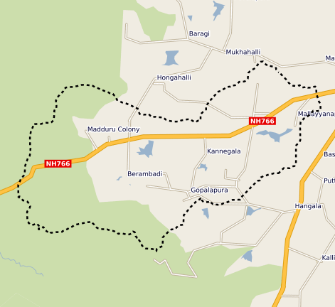
Berambadi watershed boundary
This vector map delineate the boundary of the Berambadi watershed
Simple
- Date (Publication)
- 2014-06-27T00:00:00
- Citation identifier
- fr-18007003900276-umrsas-aicha-Berambadi_watershed_boundary
- Presentation form
- Digital map
- Purpose
-
delineate the geographical area of Berambadi watershed
- Status
- Completed
- Point of contact
-
Organisation name Individual name Electronic mail address Role IFCWS / CEFIRSE BANGALORE INDIA
IFCWS / CEFIRSE BANGALORE INDIA
Point of contact
- Maintenance and update frequency
- As needed
-
external.place.thematiques
-
-
open data
-
watershed
-
- Keywords
-
-
données ouvertes
-
-
Registre de thème INSPIRE
-
-
Hydrographie
-
Installations de suivi environnemental
-
- Use limitation
-
You must mention "Source: IFCWS CEFIRSE BANGALORE INDIA" in every public use of the database as well as works produced from this data set.
- Use limitation
-
ODC-BY 1.0 license : http://opendatacommons.org/licenses/by/summary/
- Access constraints
- Other restrictions
- Use constraints
- Patent
- Spatial representation type
- Vector
- Denominator
- 25000
- Language
-
eng
- Character set
- UTF8
- Topic category
-
- Inland waters
- Boundaries
))
- Supplemental Information
-
Fields of the attribute table
ID: numéro identifiant
GRIDCODE: numéro identifiant
Name: watershed name
Area: watershed area (km²)
- Reference system identifier
- EPSG / WGS 84 / UTM zone 43N (EPSG:32643) / 7.4
- Distribution format
-
Name Version ESRI shapefile
ESRI shapefile
- Distributor contact
-
Organisation name Individual name Electronic mail address Role UMR 1069 SAS INRAE - Institut Agro
Pôle GéoSAS
Distributor
- OnLine resource
-
Protocol Linkage Name WWW:LINK-1.0-http--link
https://geosas.fr/portails/?portail=aicha Geoportal of the AICHA project
OGC:WMS
https://geosas.fr/geoserver/aicha/wms?service=WMS&request=GetCapabilities Berambadi_watershed_boundary
WWW:DOWNLOAD-1.0-http--download
https://geosas.fr/geoserver/wfs?service=WFS&version=2.0.0&request=GetFeature&typeName=aicha:Berambadi_watershed_boundary&outputFormat=SHAPE-ZIP WWW:LINK-1.0-http--link
https://www6.inrae.fr/atcha/ Atcha Project Web Site
- Hierarchy level
- Series
- Statement
-
This map was created under the Indo French Cell for Water Sciences (IFCWS - CEFIRSE). Watershed boundary was extracted from a DEM.
Metadata
- File identifier
- bd5c3775-e99c-4972-977c-a8edca9fbcd2 XML
- Metadata language
-
fre
- Character set
- UTF8
- Parent identifier
-
Berambadi site - AICHA Project
42b0d9bd-ce29-43df-98c2-0b14ab19693f
- Hierarchy level
- Dataset
- Date stamp
- 2022-03-29T17:54:17
- Metadata standard name
-
ISO 19115:2003/19139
- Metadata standard version
-
1.0
- Metadata author
-
Organisation name Individual name Electronic mail address Role IFCWS / CEFIRSE BANGALORE INDIA
IFCWS / CEFIRSE BANGALORE INDIA
Point of contact
Overviews
Spatial extent
Provided by
