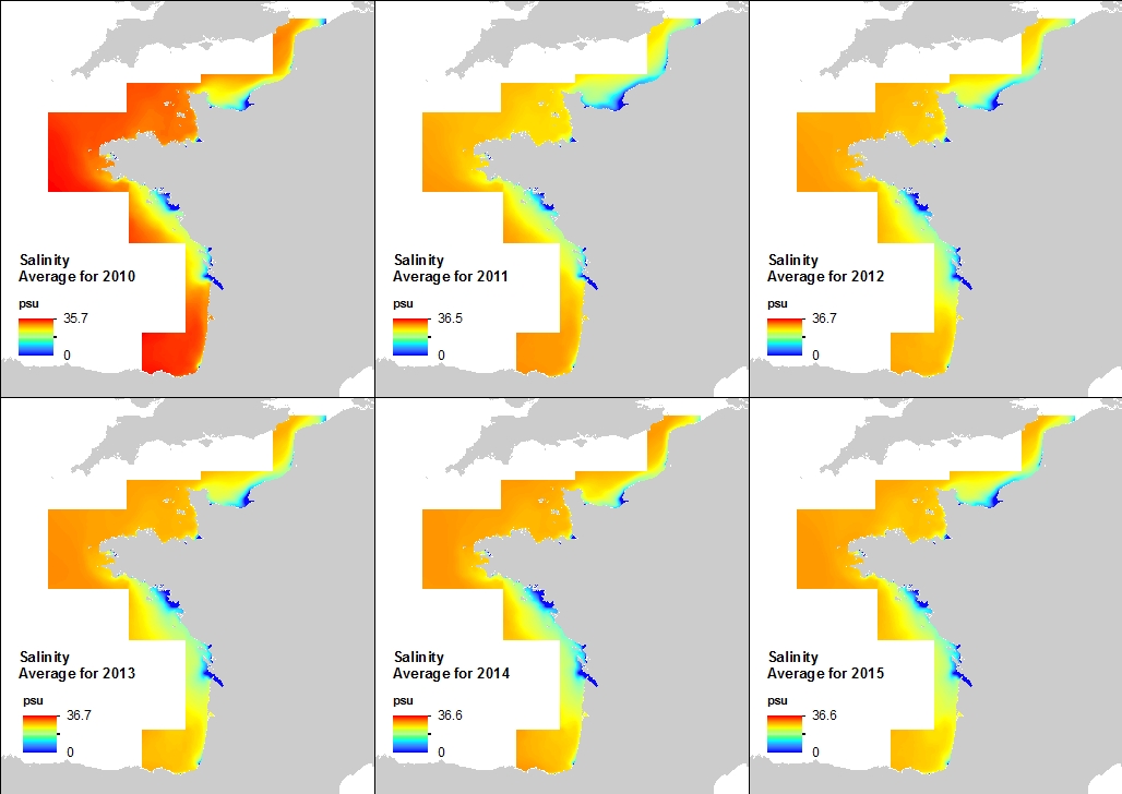
Annual Statistics of 500m Salinity at the seabed - Biscay-Channel
This annual statistics at 500m horizontal resolution was produced from the archived time series of MARS 3D physics model hindcast runs along French Atlantic Coast. The variable that is available here is the Salinity. Values are expressed in psu. The vertical level is the seabed.
Simple
- Date (Publication)
- 2016-10-20
- Citation identifier
- MANGA500_SALINITY_AT_SEA_BOTTOM
- Citation identifier
- DOI:10.12770/bc9ffb23-9940-44da-b350-af213c851842
- Purpose
-
This annual statistics was produced in order to feed into the Sedimentological Catalog of French Coasts edited by the Cerema ("Centre d’études et d’expertise sur les risques, l’environnement, la mobilité et l’aménagement", i.e. Centre For Studies and Expertise on Risks, Environment, Mobility, and Urban and Country planning)
- Credit
-
IFREMER-DYNECO
- Status
- Completed
- Point of contact
-
Organisation name Individual name Electronic mail address Role Ifremer
Caillaud Matthieu
Author Ifremer
Vasquez Mickael
Author Cerema
Roche Amélie
Point of contact Ifremer
Publisher
-
Thèmes Sextant
-
-
/Physical Environment/Coastal Hydrodynamics
-
-
GEMET - INSPIRE themes, version 1.0
-
-
Oceanographic geographical features
-
- Theme
-
-
salinity
-
annual statistics
-
hydrodynamics
-
hindcast
-
oceanography
-
- Place
-
-
Channel
-
Biscay
-
France
-
-
Cadre Réglementaire - SIMM
-
-
Directive Cadre Stratégie pour le Milieu Marin (DCSMM)
-
-
Sous-regions marines
-
-
/Metropolitan France/Bay of Biscay
-
/Metropolitan France/Channel-North Sea
-
/Metropolitan France/Celtic Seas
-
-
Thématiques - SIMM
-
-
/Environmental Status/Hydrodynamics
-
Resource specific usage
- Use limitation
-
Creative Commons license to apply : Attribution + Non Commercial + No Derivs (BY-NC-ND) : http://creativecommons.org/licenses/?lang=en
- Access constraints
- Other restrictions
- Use constraints
- Copyright
- Other constraints
-
Citation inside literature:
Caillaud Matthieu, Petton Sebastien, Dumas Franck, Rochette Sebastien, Vasquez Mickael (2016). Inter annual hydrodynamic hindcast with MARS3D-AGRIF model - Bay of biscay and Manche Areas. IFREMER-DYNECO. http://dx.doi.org/10.12770/3edee80f-5a3e-42f4-9427-9684073c87f5
- Other constraints
-
Citation inside a map:
Hindcast MANGA500 IFREMER-DYNECO
- Spatial representation type
- Grid
- Distance
- 500 meter
- Language
- Français
- Character set
- UTF8
- Topic category
-
- Oceans
))
- Begin date
- 2010-01-01
- End date
- 2015-12-31
- Reference system identifier
- EPSG / WGS 84 (EPSG:4326) / 8.6
- Distribution format
-
- OnLine resource
-
Protocol Linkage Name OGC:WMS
https://sextant.ifremer.fr/services/wms/oceanographie_physique MANGA500_SALINITY_AT_SEA_BOTTOM_2010_mean
COPYFILE
MANGA500_SALINITY_AT_SEA_BOTTOM_2010_mean
WWW:LINK-1.0-http--metadata-URL
http://doi.org/10.12770/bc9ffb23-9940-44da-b350-af213c851842 DOI du jeu de données
- OnLine resource
-
Protocol Linkage Name OGC:WMS
https://sextant.ifremer.fr/services/wms/oceanographie_physique MANGA500_SALINITY_AT_SEA_BOTTOM_2010_std
COPYFILE
MANGA500_SALINITY_AT_SEA_BOTTOM_2010_std
- OnLine resource
-
Protocol Linkage Name OGC:WMS
https://sextant.ifremer.fr/services/wms/oceanographie_physique MANGA500_SALINITY_AT_SEA_BOTTOM_2011_mean
COPYFILE
MANGA500_SALINITY_AT_SEA_BOTTOM_2011_mean
- OnLine resource
-
Protocol Linkage Name OGC:WMS
https://sextant.ifremer.fr/services/wms/oceanographie_physique MANGA500_SALINITY_AT_SEA_BOTTOM_2011_std
COPYFILE
MANGA500_SALINITY_AT_SEA_BOTTOM_2011_std
- OnLine resource
-
Protocol Linkage Name OGC:WMS
https://sextant.ifremer.fr/services/wms/oceanographie_physique MANGA500_SALINITY_AT_SEA_BOTTOM_2012_mean
COPYFILE
MANGA500_SALINITY_AT_SEA_BOTTOM_2012_mean
- OnLine resource
-
Protocol Linkage Name OGC:WMS
https://sextant.ifremer.fr/services/wms/oceanographie_physique MANGA500_SALINITY_AT_SEA_BOTTOM_2012_std
COPYFILE
MANGA500_SALINITY_AT_SEA_BOTTOM_2012_std
- OnLine resource
-
Protocol Linkage Name OGC:WMS
https://sextant.ifremer.fr/services/wms/oceanographie_physique MANGA500_SALINITY_AT_SEA_BOTTOM_2013_mean
COPYFILE
MANGA500_SALINITY_AT_SEA_BOTTOM_2013_mean
- OnLine resource
-
Protocol Linkage Name OGC:WMS
https://sextant.ifremer.fr/services/wms/oceanographie_physique MANGA500_SALINITY_AT_SEA_BOTTOM_2013_std
COPYFILE
MANGA500_SALINITY_AT_SEA_BOTTOM_2013_std
- OnLine resource
-
Protocol Linkage Name OGC:WMS
https://sextant.ifremer.fr/services/wms/oceanographie_physique MANGA500_SALINITY_AT_SEA_BOTTOM_2014_mean
COPYFILE
MANGA500_SALINITY_AT_SEA_BOTTOM_2014_mean
- OnLine resource
-
Protocol Linkage Name OGC:WMS
https://sextant.ifremer.fr/services/wms/oceanographie_physique MANGA500_SALINITY_AT_SEA_BOTTOM_2014_std
COPYFILE
MANGA500_SALINITY_AT_SEA_BOTTOM_2014_std
- OnLine resource
-
Protocol Linkage Name OGC:WMS
https://sextant.ifremer.fr/services/wms/oceanographie_physique MANGA500_SALINITY_AT_SEA_BOTTOM_2015_mean
COPYFILE
MANGA500_SALINITY_AT_SEA_BOTTOM_2015_mean
- OnLine resource
-
Protocol Linkage Name OGC:WMS
https://sextant.ifremer.fr/services/wms/oceanographie_physique MANGA500_SALINITY_AT_SEA_BOTTOM_2015_std
COPYFILE
MANGA500_SALINITY_AT_SEA_BOTTOM_2015_std
Data quality info
- Hierarchy level
- Dataset
- Statement
-
This annual statistics product was produced from the database of MARS 3D / AGRIF library (V10.10) physics model hindcast runs along French Atlantic Coast at 500m horizontal resolution, with 40 vertical levels and a time step of one hour. This database is hosted and updated by the Ifremer Dyneco Research Unit.
Metadata
- File identifier
- bc9ffb23-9940-44da-b350-af213c851842 XML
- Metadata language
- Français
- Character set
- UTF8
- Parent identifier
-
3edee80f-5a3e-42f4-9427-9684073c87f5
3edee80f-5a3e-42f4-9427-9684073c87f5
- Hierarchy level
- Dataset
- Date stamp
- 2019-11-21T15:08:27
- Metadata standard name
-
ISO 19115:2003/19139 - SEXTANT
- Metadata standard version
-
1.0
- Metadata author
-
Organisation name Individual name Electronic mail address Role IFREMER
Vasquez Mickael
Point of contact
- Other language
-
Language Character encoding English UTF8 French UTF8
 Demo Catalogue powered by geOrchestra

)))
