 Demo Catalogue powered by geOrchestra
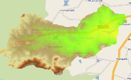
Aicha Berambadi Digital Elevation Model
This raster map is the Digital Elevation Model of the Berambadi watershed
Simple
- Date (Publication)
- 2014-06-27
- Edition
-
1.0
- Citation identifier
- fr-18007003900276-umrsas-aicha-Berambadi_DEM
- Status
- Completed
- Point of contact
-
Organisation name Individual name Electronic mail address Role IFCWS / CEFIRSE BANGALORE INDIA
IFCWS / CEFIRSE BANGALORE INDIA
Point of contact
- Maintenance and update frequency
- As needed
- Theme
-
-
Karnataka
-
Topography
-
Données ouvertes
-
-
external.place.localisation
-
-
France
-
-
UMR SAS Themes
-
-
Altimétrie
-
-
INSPIRE themes
-
-
Altitude
-
- Use limitation
-
You must mention "Source: IFCWS CEFIRSE BANGALORE INDIA" in every public use of the database as well as works produced from this data set.
- Use limitation
-
ODC-BY 1.0 license : http://opendatacommons.org/licenses/by/summary/
- Access constraints
- Other restrictions
- Use constraints
- License
- Spatial representation type
- Grid
- Distance
- 30.25 m
- Language
-
eng
- Topic category
-
- Elevation
- Description
-
France
))
- Reference system identifier
- EPSG / RGF93 / Lambert-93 (EPSG:2154) / 7.5.0.1
- Distribution format
-
Name Version GeoTIFF
1.0
Distributor
- Distributor contact
-
Organisation name Individual name Electronic mail address Role UMR 1069 SAS INRA - Agrocampus Ouest
Service GéoSAS
Distributor
- Distributor format
-
Name Version raster
1.0
- OnLine resource
-
Protocol Linkage Name OGC:WMS
https://geosas.fr/geoserver/aicha/ows?service=WMS&request=GetCapabilities Berambadi_DEM
WWW:DOWNLOAD-1.0-http--download
https://geosas.fr/geoserver/ows?service=WCS&version=2.0.1&request=GetCoverage&coverageId=aicha__Berambadi_DEM&format=geotiff WWW:LINK-1.0-http--link
https://geosas.fr/portails/?portail=aicha Geoportal of the AICHA project
WWW:LINK-1.0-http--link
https://www6.inrae.fr/atcha/ Atcha Project Web Site
- Hierarchy level
- Dataset
Conformance result
- Date (Creation)
- 2014-02-01
- Explanation
-
Non Evalué
- Pass
- Yes
- Statement
-
This map was created under the Indo French Cell for Water Sciences (IFCWS - CEFIRSE).
Metadata
- File identifier
- b1441773-8913-4ccf-96e9-01ab9b4efeda XML
- Metadata language
-
fre
- Character set
- UTF8
- Parent identifier
-
Berambadi site - AICHA Project
42b0d9bd-ce29-43df-98c2-0b14ab19693f
- Hierarchy level
- Dataset
- Date stamp
- 2022-03-30T15:02:11
- Metadata standard name
-
ISO 19115
- Metadata standard version
-
1.0
- Metadata author
-
Organisation name Individual name Electronic mail address Role IFCWS / CEFIRSE BANGALORE INDIA
IFCWS / CEFIRSE BANGALORE INDIA
Point of contact
Overviews
Spatial extent
Provided by
