 Demo Catalogue powered by geOrchestra
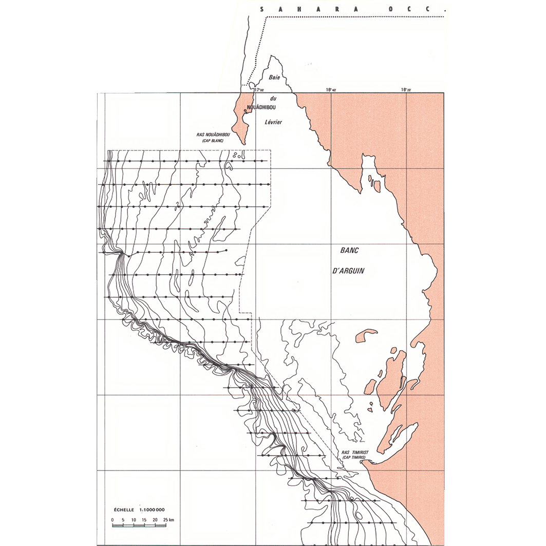
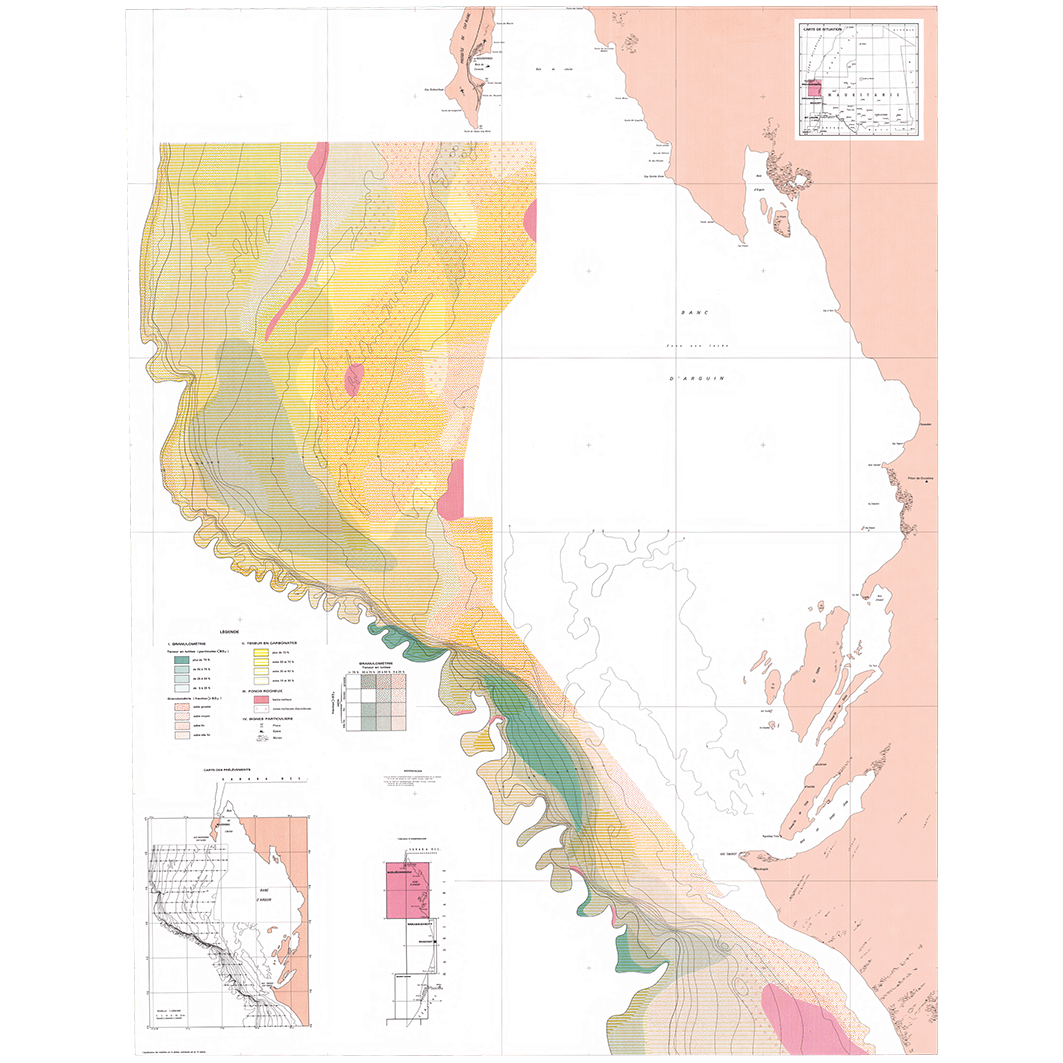
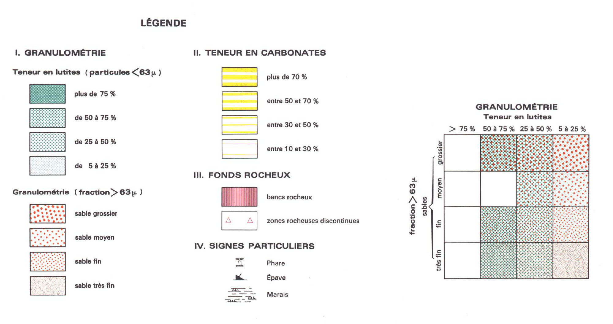
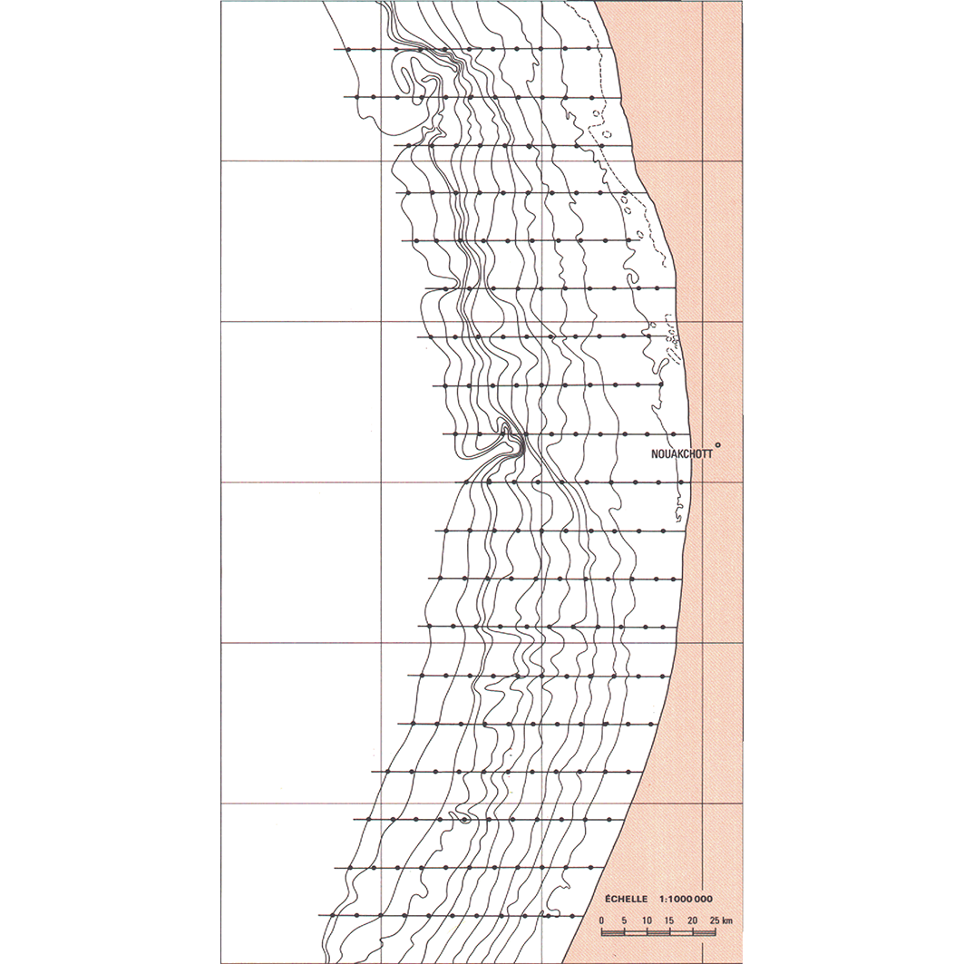
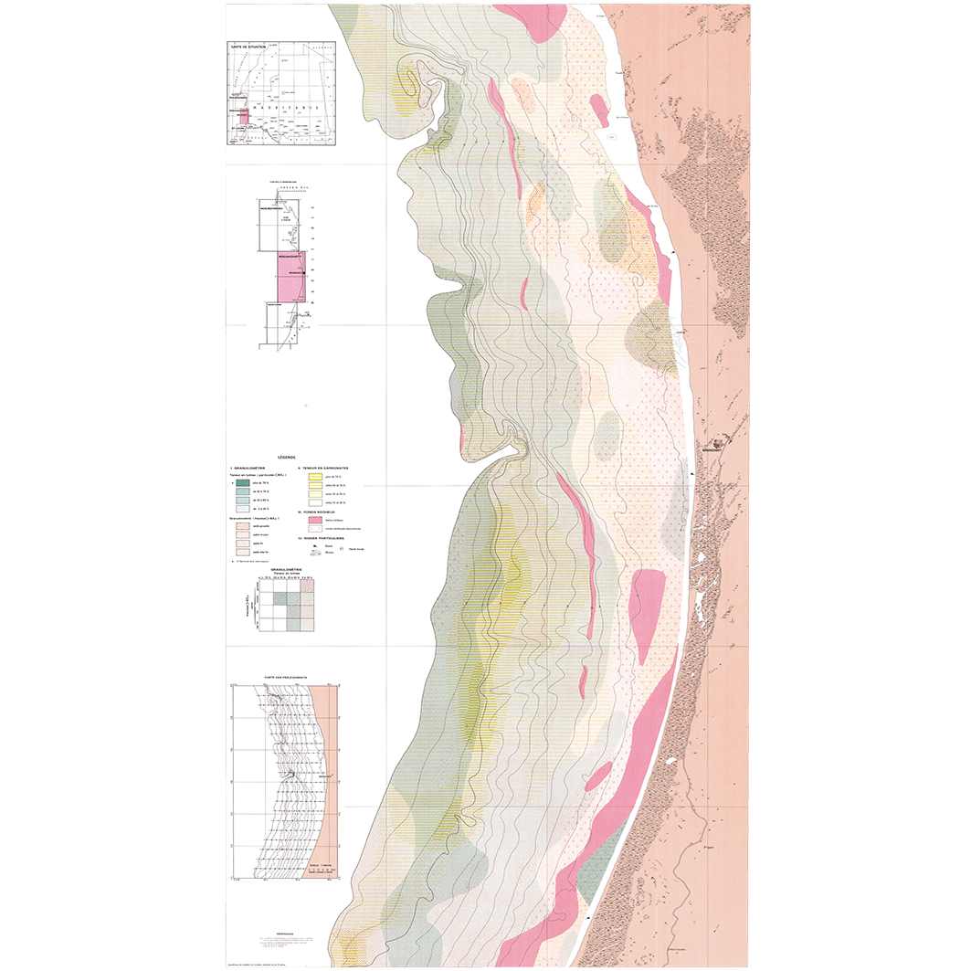
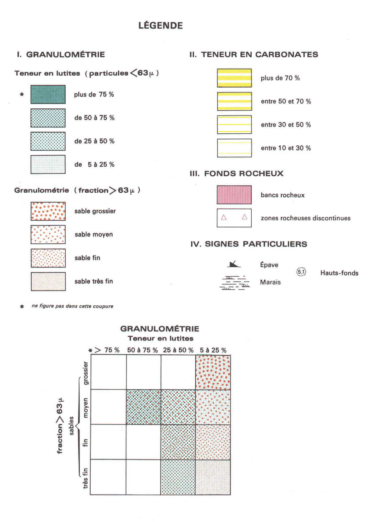
Carte sédimentologique du Plateau Continental Mauritanien. Scale of 1:1 000 000 to 1:200 000. Date of publication: 1985.
1. Nouadhibou : carte sédimentologique du Plateau Continental Mauritanien. / Domain, F.; Deruelle, R. (ill.); Weiss Michoux, S. (collab.) Scale of 1:1 000 000 to 1:200 000. Date of publication: 1985. (files: 01041RC_IRD_MRT_SEPC_1985_1000000_IRD_MRT_SEPC_1985_1000000-200000.tif, 01041RC_IRD_MRT_SEPC_1985_200000_IRD_MRT_SEPC_1985_1000000-200000.tif)
2. Nouakchott : carte sédimentologique du Plateau Continental Mauritanien. / Domain, F.; Deruelle, R. (ill.); Weiss Michoux, S. (collab.) Scale of 1:1 000 000 to 1:200 000. Date of publication: 1985. (files: 01042RC_IRD_MRT_SEPC_1985_1000000_IRD_MRT_SEPC_1985_1000000-200000.tif, 01042RC_IRD_MRT_SEPC_1985_200000_IRD_MRT_SEPC_1985_1000000-200000.tif)
Simple
- Date (Publication)
- 1985-01-01
- Citation identifier
- IRD_MRT_SEPC_1985_1000000-200000
- Credit
-
The region Île-de-France, under the project NumeriSud, supported the action to transforme around 2800 maps that are conserved at the Institut de recherche pour le développement (IRD) library in Bondy into a standard coordinate system. The transformation of the images has been done by Global Mapping Resources (South Africa) under the supervision of R. Zaiss (éditeur) 2014.
- Status
- Completed
- Point of contact
-
Organisation name Individual name Electronic mail address Role Institut de recherche pour le développement (IRD)
Production cartographique IRD
Point of contact Domain, F.
Author Deruelle, R. (ill.)
Author Weiss Michoux, S. (collab.)
collaborator CNROP, Centre national de recherches océanographiques et des pêches
editor ORSTOM, Institut français de recherche scientifique pour le développement en coopération, Unité de cartographie
editor
- Maintenance and update frequency
- Not planned
-
Geounits
-
-
Africa
-
Western Africa
-
Mauritania
-
- Theme
-
-
thematic map
-
- Keywords
-
-
project NumeriSud
-
local coverage
-
- Use limitation
-
Licence : CC-BY-NC-SA
- Access constraints
- licence
- Classification
- Unclassified
- Spatial representation type
- Grid
- Denominator
- 200000
- Language
- Français
- Character set
- UTF8
- Topic category
-
- Geoscientific information
))
- Begin date
- 1985-01-01
- End date
- 1985-12-31
- Supplemental Information
-
Publication(s):
Domain, F. (1985): Carte sédimentologique du Plateau Continental Mauritanien (entre le cap Blanc et 17°N) à 1:200 000 : feuilles Nouadhibou et Nouakchott. Paris (FRA) : ORSTOM, Institut français de recherche scientifique pour le développement en coopération, Unité de cartographie ; Nouadhibou (MRT) : CNROP, Centre national de recherches océanographiques et des pêches.
- Reference system identifier
- EPSG / 4326 / 7.9
- Distribution format
-
Name Version GeoTIFF
1.0
- Distributor contact
-
Organisation name Individual name Electronic mail address Role DataSuds-geo
Publisher
- OnLine resource
-
Protocol Linkage Name OGC:WMS
https://datasuds-geo.ird.fr/geoserver/wms sphaera_ws:01041RC_IRD_MRT_SEPC_1985_1000000_IRD_MRT_SEPC_1985_1000000-200000
WWW:DOWNLOAD:GeoTIFF https://datasuds-geo.ird.fr/geoserver/ows?service=WCS&version=2.0.1&request=GetCoverage&coverageId=01041RC_IRD_MRT_SEPC_1985_1000000_IRD_MRT_SEPC_1985_1000000-200000 WWW:LINK-1.0-http--related
https://www.documentation.ird.fr/hor/fdi:31641 Notice explicative ou autre ouvrage
- OnLine resource
-
Protocol Linkage Name OGC:WMS
https://datasuds-geo.ird.fr/geoserver/wms sphaera_ws:01041RC_IRD_MRT_SEPC_1985_200000_IRD_MRT_SEPC_1985_1000000-200000
WWW:DOWNLOAD:GeoTIFF https://datasuds-geo.ird.fr/geoserver/ows?service=WCS&version=2.0.1&request=GetCoverage&coverageId=01041RC_IRD_MRT_SEPC_1985_200000_IRD_MRT_SEPC_1985_1000000-200000 WWW:LINK-1.0-http--related
https://www.documentation.ird.fr/hor/fdi:31641 Notice explicative ou autre ouvrage
- OnLine resource
-
Protocol Linkage Name OGC:WMS
https://datasuds-geo.ird.fr/geoserver/wms sphaera_ws:01042RC_IRD_MRT_SEPC_1985_1000000_IRD_MRT_SEPC_1985_1000000-200000
WWW:DOWNLOAD:GeoTIFF https://datasuds-geo.ird.fr/geoserver/ows?service=WCS&version=2.0.1&request=GetCoverage&coverageId=01042RC_IRD_MRT_SEPC_1985_1000000_IRD_MRT_SEPC_1985_1000000-200000 WWW:LINK-1.0-http--related
https://www.documentation.ird.fr/hor/fdi:31641 Notice explicative ou autre ouvrage
- OnLine resource
-
Protocol Linkage Name OGC:WMS
https://datasuds-geo.ird.fr/geoserver/wms sphaera_ws:01042RC_IRD_MRT_SEPC_1985_200000_IRD_MRT_SEPC_1985_1000000-200000
WWW:DOWNLOAD:GeoTIFF https://datasuds-geo.ird.fr/geoserver/ows?service=WCS&version=2.0.1&request=GetCoverage&coverageId=01042RC_IRD_MRT_SEPC_1985_200000_IRD_MRT_SEPC_1985_1000000-200000 WWW:LINK-1.0-http--related
https://www.documentation.ird.fr/hor/fdi:31641 Notice explicative ou autre ouvrage
- OnLine resource
-
Protocol Linkage Name DOI
https://doi.org/10.23708/a84d0a5b-87d1-4b7a-a300-9e1675d060ef Digital Object Identifier (DOI)
- Hierarchy level
- Dataset
- Statement
-
1. Scanning to tif format, 256 colors, 250dpi.
2. Georeferencing and if possible reprojection to WGS84 (Longitude / Latitude).
3. Clipping and mosaicing of map sheets(s).
4. Export ECW format.
5. ECW to GeoTIFF format conversion.
Metadata
- File identifier
- a84d0a5b-87d1-4b7a-a300-9e1675d060ef XML
- Metadata language
- English
- Character set
- UTF8
- Hierarchy level
- Dataset
- Hierarchy level name
-
dataset
- Date stamp
- 2024-02-13T16:54:01.337089Z
- Metadata standard name
-
ISO 19115:2003/19139
- Metadata standard version
-
1.0
- Metadata author
-
Organisation name Individual name Electronic mail address Role Institut de recherche pour le développement (IRD)
Service de l'Information Scientifique et Technique (IST) IRD
Point of contact Institut de recherche pour le développement (IRD)
IRD
Resource provider
Overviews
Spatial extent
Provided by
