 Demo Catalogue powered by geOrchestra
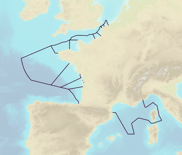
Tidal zones - Mainland France
This product includes the boundaries of tidal zones for French Channel, Atlantic and Mediterranean coasts in shapefile format. Information on the characteristics of tidal zones is available as part of the "Maritime Altimetric Reference Values" product.
Simple
- Date (Creation)
- 2014-11-18
- Citation identifier
- http://www.shom.fr/MAREE_COURANTS/ZONES_MAREE
- Point of contact
-
Organisation name Individual name Electronic mail address Role Shom
Point of contact
- Theme
-
-
tide currents
-
product
-
open data
-
- Use limitation
-
Data may be freely used providing that the source is mentioned.
- Use limitation
-
Do not use for navigation
- Use limitation
-
The product is distributed under an Opendata license (version 2.0, April 2017), defined by the Etalab mission.
- Access constraints
- License
- Use constraints
- Other restrictions
- Other constraints
-
Data may be freely used providing that the source is mentioned
- Classification
- Unclassified
- Spatial representation type
- Vector
- Language
- Français
- Character set
- UTF8
- Topic category
-
- Oceans
))
- Reference system identifier
- EPSG / WGS 84 (EPSG:4326) / 7.4
- Distribution format
-
Name Version SHAPEFILE
sans objet
- Distributor contact
-
Organisation name Individual name Electronic mail address Role Shom
Point of contact
- OnLine resource
-
Protocol Linkage Name WWW:LINK-1.0-http--link
https://data.shom.fr Shom geoportal
OGC:WMS
https://services.data.shom.fr/INSPIRE/wms/r?service=WMS&request=GetCapabilities&version=1.3.0 ZONES_MAREE_PYR_PNG_3857_WMSR
WWW:LINK-1.0-http--link
https://services.data.shom.fr/INSPIRE/telechargement/prepackageGroup/ZONES_MAREE_PACK_DIFF_DL/prepackage/ZONES_MAREE/file/ZONES_MAREE.7z Download service
- Hierarchy level
- Series
Conformance result
- Date (Publication)
- 2010-11-23
- Explanation
-
Information sur la conformité au règlement d'interopérabilité des séries et des services de données géographiques.
- Pass
- No
- Statement
-
Sources : Tidal zones are taken from the Shom tide database.
Metadata
- File identifier
- MAREE_COURANTS_ZONES_MAREE.xml XML
- Metadata language
- Français
- Character set
- UTF8
- Hierarchy level
- Series
- Hierarchy level name
-
Produit
- Date stamp
- 2014-11-21T14:09:07
- Metadata standard name
-
ISO 19115:2003/19139
- Metadata standard version
-
1.0
- Metadata author
-
Organisation name Individual name Electronic mail address Role Shom
Point of contact
- Other language
-
Language Character encoding English UTF8
Overviews
Spatial extent
Provided by
