 Demo Catalogue powered by geOrchestra
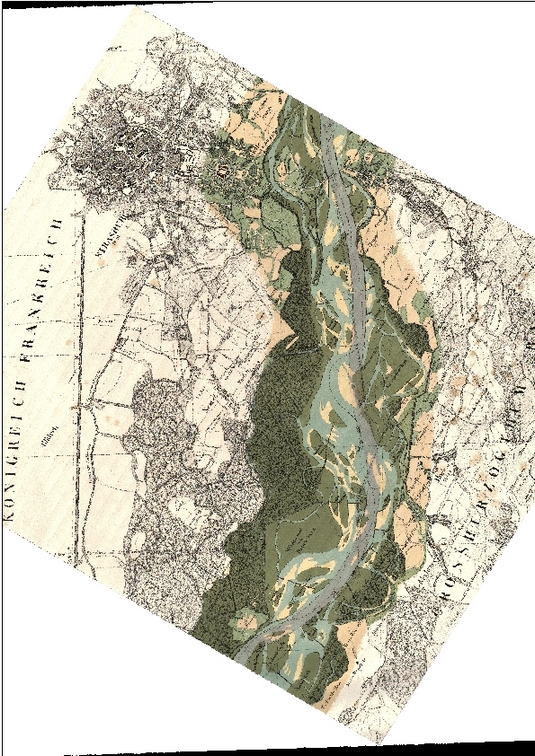
DONNEE : Scan historique du secteur de l'île du Rohrschollen - 1838 - Strasbourg
Carte topographique du cours du Rhin de 1838 géoréférencée selon l'orthophotographie de la CUS de 2010, couvrant le secteur de l'île du Rohrschollen au Sud de Strasbourg.
Transformation affine (1er ordre) avec une RMS de 16,32.
Simple
- Date (Creation)
- 1828-01-01
- Citation identifier
- / FR-130005457-201808290955-1838_ScanHisto_LIVE_Rohrschollen_L1
- Point of contact
-
Organisation name Individual name Electronic mail address Role Laboratoire Image Ville Environnement - UMR 7362, CNRS-UNISTRA
Point of contact Zone Atelier Environnementale Urbaine
Point of contact Laboratoire Image Ville Environnement - UMR 7362, CNRS-UNISTRA
ESCHBACH David
Author
- Maintenance and update frequency
- Unknown
-
INSPIRE
-
-
Occupation des terres
-
-
GEMET
-
-
occupation du sol
-
-
GEMET
-
-
carte
-
- Keywords
-
-
Rohrschollen
-
- Keywords
-
-
LIVE
-
- Keywords
-
-
ZAEU
-
- Keywords
-
-
Zone Atelier
-
- Keywords
-
-
LTSER France
-
-
GEMET - INSPIRE themes, version 1.0
-
-
Occupation des terres
-
- Use limitation
-
Acte d'engagement
- Access constraints
- Other restrictions
- Access constraints
- Other restrictions
- Other constraints
-
Pas de restriction d'accès public
- Classification
- Unclassified
- Spatial representation type
- Grid
- Language
- Français
- Character set
- UTF8
- Topic category
-
- Imagery base maps earth cover
))
- Reference system identifier
- NTF (Paris) / Lambert Nord France - EPSG 27561
- Distribution format
-
Name Version TIFF
- OnLine resource
-
Protocol Linkage Name https://www.datagrandest.fr/geonetwork/srv/fre/catalog.search#/metadata/FR-130005457-201808290955-1838_Carte_LIVE_Rohrschollen_L1 CARTE : Ile du Rohrschollen en 1838
- Hierarchy level
- Dataset
- Statement
-
Le raster a été géoréférencé et donc légerement dégradé par la transformation. Bonne visualisation jusqu’à 1/2000.
Bien que la carte soit en couleur et agréable à visualiser, elle est moins précise que certaines cartes plus anciennes. Les unités écomorphologiques ont des contours lisses, les bornes frontières sont moins bien représentées etc.
Metadata
- File identifier
- FR-130005457-201808290955-1838_ScanHisto_LIVE_Rohrschollen_L1 XML
- Metadata language
- Français
- Character set
- UTF8
- Hierarchy level
- Dataset
- Date stamp
- 2018-11-16T14:50:28
- Metadata standard name
-
ISO 19115/19139
- Metadata standard version
-
Cor 1:2006
- Metadata author
-
Organisation name Individual name Electronic mail address Role Laboratoire Image Ville Environnement - UMR 7362, CNRS-UNISTRA
Point of contact Zone Atelier Environnementale Urbaine
Point of contact Laboratoire Image Ville Environnement - UMR 7362, CNRS-UNISTRA
ESCHBACH David
Author
Overviews
Spatial extent
)))
Provided by
