 Demo Catalogue powered by geOrchestra
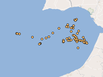
WMS Submarine fluid emissions in Portugal
Location of structures resulting from the submarine fluids emissions, such as: mud volcanoes (methane hydrates); Pockmaks (methane) and hydrothermal vents (fluids enriched in salts and metallic elements), located between the Mid-Atlantic Rift zone (Azores archipelago) and the continental margin.
Simple
Identification info
- Date (Creation)
- 2017-01-23
- Citation identifier
- http://ipma.pt/features/geology/sdg / 3a07443b-628b-4323-aab4-d25ec654d609
- Citation identifier
- offshoremfe
- Point of contact
-
Organisation name Individual name Electronic mail address Role Instituto Português do Mar e da Atmosfera, I.P. (IPMA, I.P.)
Divisão de Sistemas de Informação, Comunicações e Desenvolvimento Tecnológico (DivSI)
Point of contact
- Maintenance and update frequency
- As needed
-
ISO - 19119 geographic services taxonomy
-
-
infoMapAccessService
-
-
Thesaurus SNIMar v.1.0
-
-
Batimetria e Geomorfologia Marinha
-
-
Thesaurus SNIMar v.1.0
-
-
Geologia Marinha e Costeira
-
-
Thesaurus SNIMar v.1.0
-
-
Geossítios
-
- Keywords
-
-
IPMA, I.P.
-
- Use limitation
-
Sem restrições
- Access constraints
- Other restrictions
- Use constraints
- Other restrictions
- Other constraints
-
O acesso à informação disponibilizada é público mas a sua utilização não poderá ter fins lucrativos ou ofensivos e deverá, sempre, referir a fonte de informação IPMA, I.P.
- Service Type
- view
))
- Coupling Type
- Tight
- Contains Operations
-
Operation Name Distributed Computing Platforms Connect Point GetMap
Web services http://maps.ipma.pt/mapserv?map=/var/www/maps/features/geology/offshoremfe_wms.map GetCapabilities
Web services http://maps.ipma.pt/mapserv?map=/var/www/maps/features/geology/offshoremfe_wms.map GetFeatureInfo
Web services http://maps.ipma.pt/mapserv?map=/var/www/maps/features/geology/offshoremfe_wms.map
- Reference system identifier
- EPSG / http://www.opengis.net/def/crs/EPSG/0/4258
- Reference system identifier
- EPSG / http://www.opengis.net/def/crs/EPSG/0/4326
- Distribution format
-
Name Version WMS
1.3
- OnLine resource
-
Protocol Linkage Name http://maps.ipma.pt/mapserv?map=/var/www/maps/features/geology/offshoremfe_wms.map
- Hierarchy level
- Service
Extent
- Dataset
-
3a07443b-628b-4323-aab4-d25ec654d609
- Dataset
-
offshoremfe
Conformance result
- Date (Publication)
- 2010-11-23
- Explanation
-
Ver a especificação citada.
- Pass
- No
Metadata
- File identifier
- 9bd86975-e729-43b7-b124-3c6f693c3b33 XML
- Metadata language
- Portuguese
- Character set
- UTF8
- Hierarchy level
- Service
- Date stamp
- 2017-04-10
- Metadata standard name
-
Perfil SNIMar
- Metadata standard version
-
v.0.9.3
- Metadata author
-
Organisation name Individual name Electronic mail address Role Instituto Português do Mar e da Atmosfera, I.P. (IPMA, I.P.)
Point of contact
- Other language
-
Language Character encoding English UTF8
Overviews
Spatial extent
Provided by
