 Demo Catalogue powered by geOrchestra
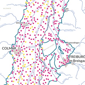
ERMES - Context: Common measurement points for the last three cross-border campaigns
Measurement point common to the 2003-2009-2016 campaigns.
Simple
- Date (Creation)
- 2016-01-01
- Date (Publication)
- 2018-11-01
- Citation identifier
- Carte4_ERMES
- Status
- Completed
- Point of contact
-
Organisation name Individual name Electronic mail address Role GeoRhena
GeoRhena
GeoRhena
Point of contact Association pour la Protection de la Nappe Phréatique de la Plaine d'Alsace (APRONA)
Processor Water Resources Expert Committee
Originator Landesanstalt für Umwelt Baden-Württemberg (LUBW)
Custodian Regierungspräsidium Freiburg -Gewässer und Boden (RPF-GB)
Custodian Regierungspräsidium Freiburg - Landesamt für Geologie, Rohstoffe und Bergbau (RPF-LGRB)
Custodian Landesamt für Umwelt -- Rheinland-Pfalz (LfU –RP)
Custodian Struktur- und Genehmigungsdirektion Süd Rheinland-Pfalz (SGD-Süd-RP)
Custodian Amt für Umweltschutz und Energie, Basel-Stadt (AUE-BS)
Custodian Région Grand-Est (RGE)
Custodian Direction Régionale de l’Environnement, Aménagement et du Logement (DREAL)
Custodian BRGM Service Géologique Régional d’Alsace (BRGM)
Custodian Association pour la Protection de la Nappe Phréatique de la Plaine d'Alsace (APRONA)
Custodian Landesamt für Geologie und Bergbau Rheinland-Pfalz (LGB-RP)
Custodian Amt für Umweltschutz und Energie, Basel-Landschaft (AUE-BL)
Custodian
- Maintenance and update frequency
- Not planned
- Keywords
-
-
Map
-
- Keywords
-
-
Upper Rhine
-
-
GEMET - Concepts, version 2.4
-
-
drinking water
-
water pollution
-
water quality
-
- Use limitation
-
Licence CC BY
- Access constraints
- Other restrictions
- Use constraints
- Other restrictions
- Other constraints
-
No other limitation
- Denominator
- 100000
- Language
- Français
- Character set
- UTF8
- Topic category
-
- Environment
- Health
- Begin date
- 2013-01-01
- End date
- 2016-12-31
))
- Distribution format
-
Name Version PDF Map
-
- OnLine resource
-
Protocol Linkage Name WWW:DOWNLOAD-1.0-http--download
https://www.georhena.eu/sites/default/files/Cartes/Carte4_ERMES_trans_2016_GENERAL_reseau_communs_2003_2009_2016.pdf Pdf Download
Metadata
- File identifier
- 8dbd85e5-2d73-4273-810c-ad7ad899c84d XML
- Metadata language
- Français
- Character set
- UTF8
- Hierarchy level
- Static map
- Hierarchy level name
-
Carte statique
- Date stamp
- 2022-10-13T07:55:34.317881Z
- Metadata standard name
-
ISO 19115:2003/19139
- Metadata standard version
-
1.0
- Metadata author
-
Organisation name Individual name Electronic mail address Role GeoRhena: Geographical Information System of the Upper Rhine
Author
- Other language
-
Language Character encoding German UTF8 English UTF8 French UTF8
)))
