 Demo Catalogue powered by geOrchestra
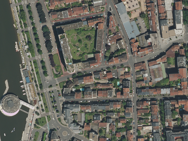
Orthophotographie couleur - Agglomération de Vichy - PVA été 2013
Le produit Orthophotographie couleur - Agglomération de Vichy est une orthophotographie numérique en couleurs, rectifiée dans la projection associée au système géodésique RGF93. Résolution : 0,10m - Précision planimétrique : 0,20m - Dévers < 29% - Dévers zone urbaine < 15%.
Les données sont téléchargeables en Open Data depuis le catalogue au format JPEG2000 (775 fichiers pour 13Go).
Taille et poids des données rééchantillonnées : 1jp2 - 14G.
Projet co-financé par l'Union européenne - Fonds européen de développement régional - L'Europe s'engage en Auvergne.
Mission réalisée par Sintégra et APEI
Simple
- Alternate title
-
Base de Données Orthophotographique
- Date (Publication)
- 2013-06-07
- Citation identifier
- fr-130014582-vichy2013
- Purpose
-
Le produit "Orthophotographie couleur - Agglomération de Vichy" se compose d'images numériques (sans habillage ni surcharge) et d'indications de géoréférencement. Le contenu informationnel permet localement une utilisation jusqu'au 1 :500ième pour mettre en valeur le territoire, enrichir la visualisation des données et des projets.
- Status
- Completed
- Point of contact
-
Organisation name Individual name Electronic mail address Role Centre Régional Auvergne-Rhône-Alpes de l'Information Géographique (CRAIG)
Owner Centre Régional Auvergne-Rhône-Alpes de l'Information Géographique (CRAIG)
Point of contact
- Maintenance and update frequency
- As needed
- Theme
-
-
orthophotoplan
-
orthophotographie
-
prises de vues aériennes
-
open data
-
données ouvertes
-
- Place
-
-
Agglomération de Vichy
-
VVA
-
-
COVADIS themes
-
-
REFERENTIELS - ORTHOPHOTOGRAPHIE
-
-
Communes de France
-
GEMET - INSPIRE themes, version 1.0
-
-
Ortho-imagerie
-
- Use limitation
-
Licence ouverte / Open license
- Use limitation
-
1- Mentions obligatoires : "CRAIG-SINTEGRA 2013"
- Use limitation
-
"Projet cofinancés par l'Union européenne - fonds européen de développement régional FEDER" cette mention devra être accompagnée du logo de l'Union européenne en Auvergne disponible à cette adresse : http://fichiers.craig.fr/temp/LOGO/logo%20Union%20Europ%e9enne.jpg
- Access constraints
- License
- Use constraints
- License
- Other constraints
-
Licence ouverte/Open license
- Other constraints
-
Pas de restriction d’accès public selon INSPIRE
- Spatial representation type
- Grid
- Distance
- 0.1 m
- Language
- Français
- Topic category
-
- Location
- Imagery base maps earth cover
- Description
-
Agglomération de Vichy
))
- Supplemental Information
-
Les prises de vues sont réalisées avec une caméra numérique qui assure un contenu radiométrique plus riche et plus stable. Le produit "Orthophotographie couleur - Agglomération de Vichy" est livrable au format TIFF (Tagged Image File Format) en dalles de 0,750 km x 0,750 km, ou au format JPG2000.
- Reference system identifier
- EPSG / RGF93 / Lambert-93 (EPSG:2154) / 7.4
Spatial representation info
- Distribution format
-
Name Version JPG2000
1.0
- Distributor contact
-
Organisation name Individual name Electronic mail address Role CRAIG
Distributor
- Units of distribution
-
Agglomération de Vichy
- OnLine resource
-
Protocol Linkage Name WWW:LINK-1.0-http--link
http://www.craig.fr Site internet du CRAIG
WWW:LINK-1.0-http--link
https://drive.opendata.craig.fr/s/opendata?path=%2Fortho%2F2013_vichy_10cm Télécharger les données
OGC:WMS
https://tiles.craig.fr/ortho? ortho_2013
- Hierarchy level
- Dataset
Conformance result
- Date (Publication)
- 2013-10-21
- Explanation
-
Degré de conformité de la ressource par rapport aux spécifications visées d'Inspire (Conforme, Non Conforme, Non Evalué)
- Pass
- No
- Statement
-
Produit par le groupement d'entreprises APEI-SINTEGRA pour le Centre Régional Auvergnat de l'Information Géographique (CRAIG)
Metadata
- File identifier
- 894ad61c-8e42-4b01-9c0a-0ac7530ab4d2 XML
- Metadata language
- Français
- Character set
- UTF8
- Hierarchy level
- Dataset
- Date stamp
- 2023-02-28T15:39:09.345171Z
- Metadata standard name
-
ISO 19115
- Metadata standard version
-
2003 Cor.1:2006
- Metadata author
-
Organisation name Individual name Electronic mail address Role Centre Régional Auvergne-Rhône-Alpes de l'Information Géographique (CRAIG)
Point of contact
Overviews
Spatial extent
Provided by
