 Demo Catalogue powered by geOrchestra
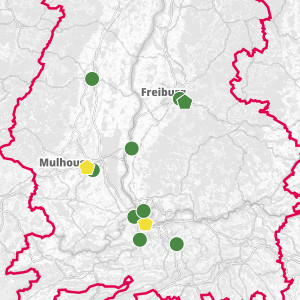
Air quality monitoring stations on the Upper Rhine
This dataset presents the air quality measurement stations in the Upper Rhine region. These stations are monitored by ATMO Grand Est, the Landesanstalt für Umwelt Baden-Württemberg (LUBW) and the cantons of Basel-Stadt and Basel-Landschaft for France, Germany and Switzerland respectively.
By consulting this resource, you will find the annual averages recorded at these stations for nitrogen dioxide (NO2), ozone (O3) and fine particles (PM10 and PM2.5). You can consult the interactive map in the associated resource for an overview of all the indicators.
Simple
- Date (Creation)
- 2024-05-01
- Date (Publication)
- 2024-02-19
- Citation identifier
- air_station_mesure_qualite
- Status
- Completed
- Point of contact
-
Organisation name Individual name Electronic mail address Role GeoRhena
Point of contact ATMO Grand Est
Custodian
- Maintenance and update frequency
- Annually
- Theme
-
-
Upper Rhine
-
Crossborder
-
-
GEMET - Concepts, version 2.4
-
-
air
-
atmospheric pollution
-
monitoring station
-
- Use limitation
-
CC-BY Licence ©OpenStreetMap contributors ©GeoRhena
- Access constraints
- Other restrictions
- Use constraints
- Other restrictions
- Other constraints
-
No other limitation
- Aggregate Datasetindentifier
- 73fe4de4-42ef-42c3-b633-574c22381c29
- Association Type
- Cross reference
- Initiative Type
- Collection
- Spatial representation type
- Vector
- Denominator
- 50000
- Language
- Français
- Language
- Deutsch
- Language
- English
- Character set
- UTF8
- Topic category
-
- Environment
- Health
- Begin date
- 2024-01-01
- End date
- 2024-12-31
))
- Distribution format
-
Name Version SHP GeoData
-
- OnLine resource
-
Protocol Linkage Name OGC:WMS
https://geoportal.georhena.eu/geoserver/environment/ows air_station_mesure_qualite
OGC:WFS
https://geoportal.georhena.eu/geoserver/environment/wfs environment:air_station_mesure_qualite
WWW:DOWNLOAD-1.0-ftp--download https://geoportal.georhena.eu/geoserver/environment/ows?request=GetFeature&service=WFS&typeName=air_station_mesure_qualite&version=1.0.0&outputFormat=SHAPE-ZIP Téléchargement du Shapefile
- OnLine resource
-
Protocol Linkage Name WWW:LINK-1.0-http--related https://geoportal.georhena.eu/mapstore/#/viewer/openlayers/660 Air quality in the Upper Rhine region
- Hierarchy level
- Dataset
- Statement
-
Data extracted from Openstreetmap and post-processed by GeoRhena
Metadata
- File identifier
- 8419c400-34cd-41d9-92b4-8edbf6a55ab3 XML
- Metadata language
- Français
- Character set
- UTF8
- Hierarchy level
- Dataset
- Date stamp
- 2024-12-19T10:36:33.036534Z
- Metadata standard name
-
ISO 19115:2003/19139
- Metadata standard version
-
1.0
- Metadata author
-
Organisation name Individual name Electronic mail address Role GeoRhena: Geographical Information System of the Upper Rhine
Point of contact
- Other language
-
Language Character encoding English UTF8 German UTF8 French UTF8
)))
