 Demo Catalogue powered by geOrchestra
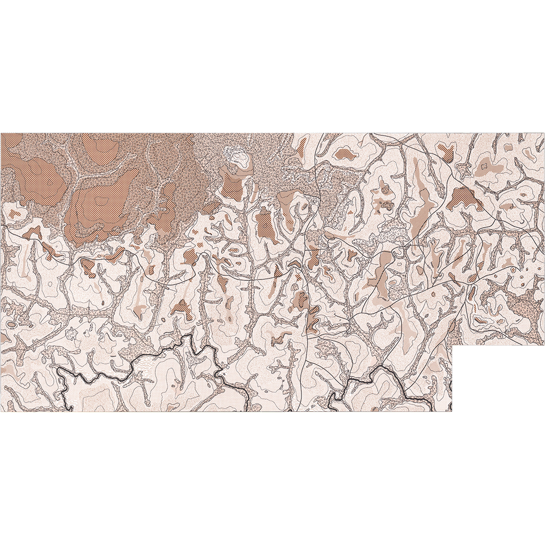
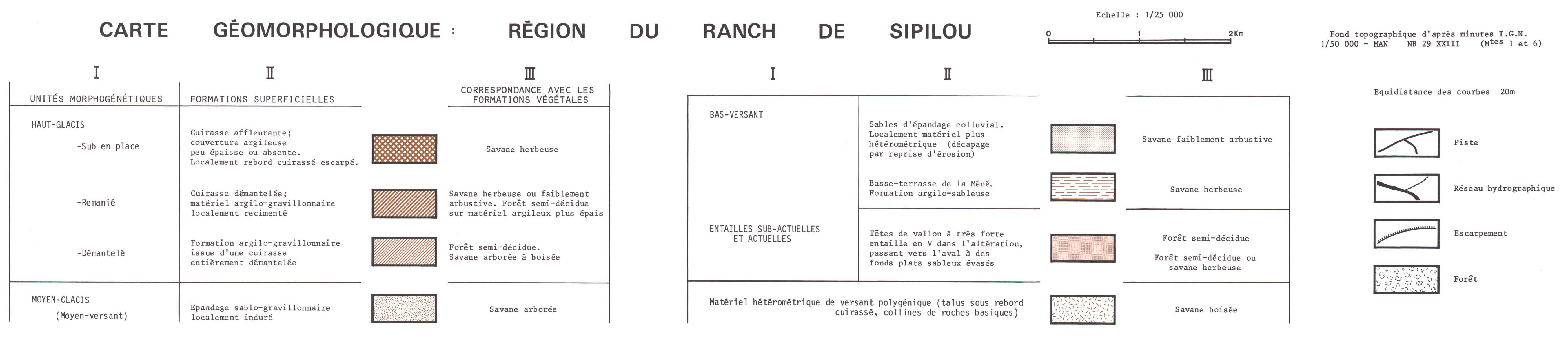
Carte géomorphologique : région du ranch de Sipilou. Scale of 1:25 000. Date of publication: 1976.
1. Carte géomorphologique : région du ranch de Sipilou. / Avenard, Jean Michel; Maurer, A. (ill.); Scale of 1:25 000. Date of publication: 1976. (file: 00897RC_IRD_CIV_GMOR_1976_25000_IRD_CIV_GMOR_1976_25000.tif)
Simple
- Date (Publication)
- 1976-01-01
- Citation identifier
- IRD_CIV_GMOR_1976_25000
- Credit
-
The region Île-de-France, under the project NumeriSud, supported the action to transforme around 2800 maps that are conserved at the Institut de recherche pour le développement (IRD) library in Bondy into a standard coordinate system. The transformation of the images has been done by Global Mapping Resources (South Africa) under the supervision of R. Zaiss (éditeur) 2014.
- Status
- Completed
- Point of contact
-
Organisation name Individual name Electronic mail address Role Institut de recherche pour le développement (IRD)
Production cartographique IRD
Point of contact Avenard, Jean Michel
Author Maurer, A. (ill.)
Author ORSTOM, Office de la recherche scientifique et technique outre-mer
editor Université Louis Pasteur Strasbourg, Centre de géographie appliquée
editor
- Maintenance and update frequency
- Not planned
-
Geounits
-
-
Africa
-
Western Africa
-
Ivory Coast
-
- Theme
-
-
thematic map
-
- Keywords
-
-
project NumeriSud
-
local coverage
-
- Use limitation
-
Licence : CC-BY-NC-SA
- Access constraints
- licence
- Classification
- Unclassified
- Spatial representation type
- Grid
- Denominator
- 25000
- Language
- Français
- Character set
- UTF8
- Topic category
-
- Geoscientific information
))
- Begin date
- 1976-01-01
- End date
- 1976-12-31
- Supplemental Information
-
Publication(s):
Avenard, J. M. (1976): Cartographie géomorphologique dans l'ouest de la Côte d'Ivoire: quelques exemples de l'évolution géomorphologique régionale. Son incidence sur la répartition actuelle des formations végétales. Paris (FRA) : ORSTOM, Office de la recherche scientifique et technique outre mer ; Strasbourg (FRA) : Université Louis Pasteur Strasbourg, Centre de géographie appliquée.
- Reference system identifier
- EPSG / 4326 / 7.9
- Distribution format
-
Name Version GeoTIFF
1.0
- Distributor contact
-
Organisation name Individual name Electronic mail address Role DataSuds-geo
Publisher
- OnLine resource
-
Protocol Linkage Name OGC:WMS
https://datasuds-geo.ird.fr/geoserver/wms sphaera_ws:00897RC_IRD_CIV_GMOR_1976_25000_IRD_CIV_GMOR_1976_25000
WWW:DOWNLOAD:GeoTIFF https://datasuds-geo.ird.fr/geoserver/ows?service=WCS&version=2.0.1&request=GetCoverage&coverageId=00897RC_IRD_CIV_GMOR_1976_25000_IRD_CIV_GMOR_1976_25000 WWW:LINK-1.0-http--related
https://www.documentation.ird.fr/hor/fdi:09001 Notice explicative ou autre ouvrage
- OnLine resource
-
Protocol Linkage Name DOI
https://doi.org/10.23708/771bb0b0-9dc1-46b5-9b3d-cb9f59902710 Digital Object Identifier (DOI)
- Hierarchy level
- Dataset
- Statement
-
1. Scanning to tif format, 256 colors, 250dpi.
2. Georeferencing and if possible reprojection to WGS84 (Longitude / Latitude).
3. Clipping and mosaicing of map sheets(s).
4. Export ECW format.
5. ECW to GeoTIFF format conversion.
Metadata
- File identifier
- 771bb0b0-9dc1-46b5-9b3d-cb9f59902710 XML
- Metadata language
- English
- Character set
- UTF8
- Hierarchy level
- Dataset
- Hierarchy level name
-
dataset
- Date stamp
- 2024-02-13T18:34:43.098282Z
- Metadata standard name
-
ISO 19115:2003/19139
- Metadata standard version
-
1.0
- Metadata author
-
Organisation name Individual name Electronic mail address Role Institut de recherche pour le développement (IRD)
Service de l'Information Scientifique et Technique (IST) IRD
Point of contact Institut de recherche pour le développement (IRD)
IRD
Resource provider
Overviews
Spatial extent
Provided by
