 Demo Catalogue powered by geOrchestra
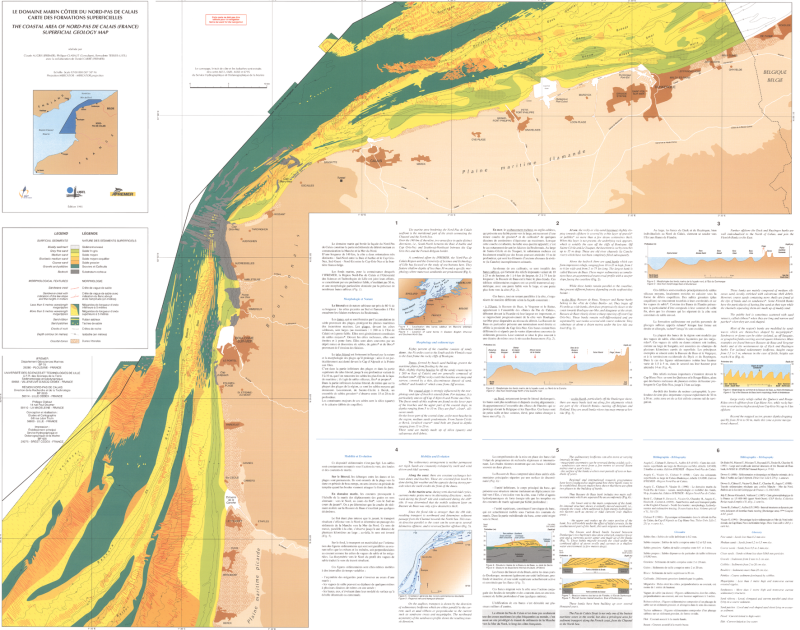
Formations superficielles du domaine marin côtier du Nord - Pas-de-Calais (C. Augris, 1995), scan géoréférencé
Scan géoréférencé de la carte "Le domaine marin côtier du Nord-Pas-de-Calais - Carte des formations superficielles" Edition 1995. Echelle 1/40 000.
Campagnes océanographiques à l'origine de cette carte :
- AUGRIS Claude (1983) GRANOR 83 cruise, RV Thalia, https://doi.org/10.17600/830024 11
- AUGRIS Claude (1984) GRANOR 84 cruise, RV La Pelagia, https://doi.org/10.17600/84004 311
- AUGRIS Claude, BERNE Serge (1985) GRANOR 85 cruise, RV Cryos, https://doi.org/10.17600/8500 5211
- AUGRIS Claude, CLABAUT Philipe (1986 ) PASCAL cruise, https://campagnes.flotteoceanographique.fr/campagnes/86006211/
- AUGRIS Claude (1988) FOCAL 88 LEG1 cruise, RV Thalia, https://doi.org/10.17600/880 11511
- AUGRIS Claude (1988) FOCAL 88 LEG2 cruise, RV Cryos, https://doi.org/10.17600/88006 511
Référence bibliographique : AUGRIS C., CLABAUT P., TESSIER B. (1995) - Le domaine marin du Nord-Pas de Calais, carte des formations superficielles. Echelle 1/100 000. Ed. Ifremer - Région Nord-Pas de Calais - Université des Sciences et Technologies de Lille.
Simple
- Date (Publication)
- 1995-01-01T00:00:00
- Date (Revision)
- 2006-08-01T00:00:00
- Edition
-
Edition Ifremer
- Edition date
- 1995-01-01T00:00:00
- Citation identifier
- FR-330-715-368-00032-FormationsSup_PasCalais_Augris_1995_ScanGeoref
- Presentation form
- Digital map
- Credit
-
Ifremer / Région nord-Pas-De-Calais / Université des sciences et technologies de Lille
- Status
- Completed
- Point of contact
-
Organisation name Individual name Electronic mail address Role Ifremer
AUGRIS Claude
Author Ifremer
Geo-Ocean
Point of contact Consultant
CLABAUT Philippe
Author CNRS
TESSIER Bernadette
Author
- Maintenance and update frequency
- Not planned
-
Thèmes Sextant
-
-
/Cartes scannées/Ifremer/Sédimentologie
-
-
GEMET - INSPIRE themes, version 1.0
-
-
Géologie
-
-
external.theme.gemet
-
-
fond marin
-
sédiment marin
-
- Theme
-
-
formations superficielles
-
nature des fonds
-
- Place
-
-
Nord-Pas de Calais
-
- Discipline
-
-
géophysique
-
sédimentologie
-
- Use limitation
- CC-BY (Creative Commons - Attribution)
- Access constraints
- Other restrictions
- Use constraints
- License
- Other constraints
-
Pas de restriction d'accès public
- Other constraints
-
Proposition de citation : AUGRIS C., CLABAUT P., TESSIER B. (1995) - Le domaine marin du Nord-Pas de Calais, carte des formations superficielles. Echelle 1/100 000. Ed. Ifremer - Région Nord-Pas de Calais - Université des Sciences et Technologies de Lille.
- Spatial representation type
- Grid
- Denominator
- 100000
- Language
- Français
- Character set
- UTF8
- Topic category
-
- Geoscientific information
- Description
-
période d'acquisition des données
- Begin date
- 1983-07-03T00:00:00
- End date
- 1988-07-04T00:00:00
))
- Reference system identifier
- EPSG / ED50 (EPSG:4230) / 7.4
- Number of dimensions
- 2
- Dimension name
- Column
- Dimension size
- 4936
- Resolution
- 21.25101 m
- Dimension name
- Row
- Dimension size
- 3892
- Resolution
- 21.23158 m
- Cell geometry
- Area
- Transformation parameter availability
- No
- Distribution format
-
Name Version GeoTIFF
1.0
- Distributor contact
-
Organisation name Individual name Electronic mail address Role Ifremer -Centre de Brest
Distributor
- OnLine resource
-
Protocol Linkage Name OGC:WMS
https://sextant.ifremer.fr/services/wms/gm_geologie FormationsSup_PasCalais_Augris_1995_ScanGeoref
WWW:LINK
http://dx.doi.org/10.17600/83002411 WWW:LINK
http://dx.doi.org/10.17600/84004311 WWW:LINK
http://dx.doi.org/10.17600/85005211 WWW:LINK
http://www.ifremer.fr/sismerData/jsp/visualisationMetadata2.jsp?strPortail=ifremer&langue=FR&pageOrigine=CAM&cle1=FI351986006211 WWW:LINK
http://dx.doi.org/10.17600/88011511 WWW:LINK
http://dx.doi.org/10.17600/88006511
- Hierarchy level
- Dataset
Conformance result
- Date (Publication)
- 2007-03-14
- Explanation
-
Non évalué
- Pass
- No
- Statement
-
Cette carte est la synthèse de deux cartes à une échelle plus grande :
- carte des sédiments superficiels au large de Boulogne-sur-mer (édition 1987 ; Echelle 1/43 400)
- carte des sédiments superficiels au large de Calais-Dunkerque (édition 1989 ; Echelle 1/43 100)
2006 : Carte originale papier scannée et géoréférencée.
Metadata
- File identifier
- 683f9e80-bbec-11df-a9b6-005056987263 XML
- Metadata language
- Français
- Character set
- UTF8
- Hierarchy level
- Dataset
- Date stamp
- 2023-05-23T14:01:15.962Z
- Metadata standard name
-
ISO 19115:2003/19139 - SEXTANT
- Metadata standard version
-
1.0
- Metadata author
-
Organisation name Individual name Electronic mail address Role Ifremer
Geo-Ocean
Point of contact
Overviews
Spatial extent
Provided by
