 Demo Catalogue powered by geOrchestra
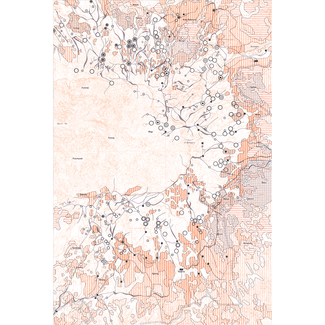
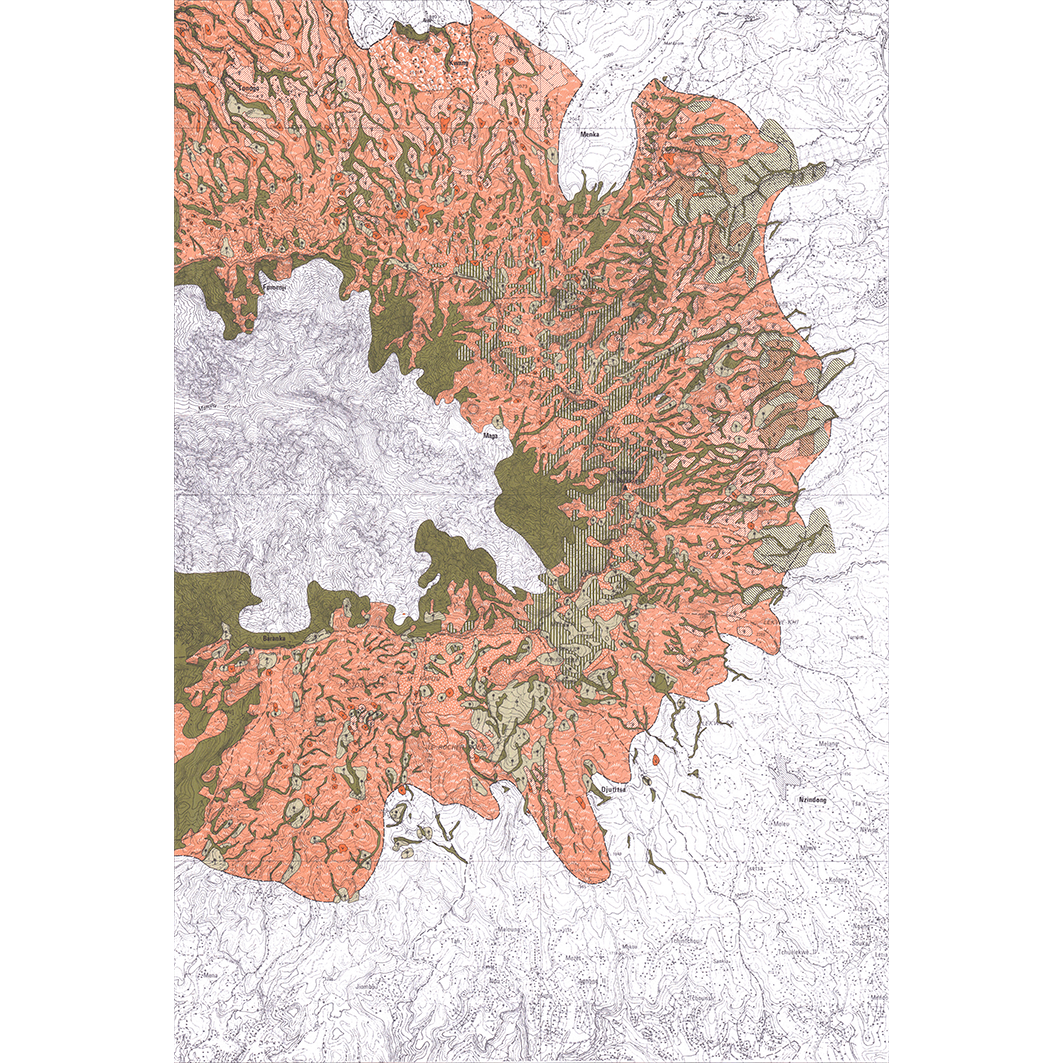
Cameroun : plateaux de l'ouest. Scale of 1:2 000 000 to 1:50 000. Date of publication: 1986-1991.
1. Cameroun : Monts Bambouto : évolution de l'occupation du sol : carte N°7. / Boutrais, Jean; Scale of 1:50 000. Date of publication: 1989. (file: 01409RC_IRD_CMR_USOL_1989_50000_IRD_CMR_CSRE_1986-91_2000000-50000.tif)
2. Cameroun : Monts Bambouto : végétation de la zone d'élevage : carte No 3. / Boutrais, Jean; Weiss, S. (ill.); Scale of 1:50 000. Date of publication: 1990. (file: 01405RC_IRD_CMR_VEGE_1990_50000_IRD_CMR_CSRE_1986-91_2000000-50000.tif)
3. Cameroun : plateaux de l'ouest : carte de repérage : carte N°2. / Boutrais, Jean; Weiss, S. (ill.); Scale of 1:270 270. Date of publication: 1991. (file: 01404RC_IRD_CMR_ILSI_1991_270270_IRD_CMR_CSRE_1986-91_2000000-50000.tif)
4. Cameroun : plateaux de l'ouest : culture du café et élevage paysan : carte No 4. / Boutrais, Jean; Weiss, S. (collab.) Scale of 1:270 270. Date of publication: 1986. (file: 01406RC_IRD_CMR_AGCE_1986_270270_IRD_CMR_CSRE_1986-91_2000000-50000.tif)
5. Cameroun : plateaux de l'ouest : élevage paysan et cultures vivrières masculines : carte No 5. / Boutrais, Jean; Weiss, S. (collab.) Scale of 1:270 270. Date of publication: 1986. (file: 01407RC_IRD_CMR_AGCU_1986_270270_IRD_CMR_CSRE_1986-91_2000000-50000.tif)
6. Cameroun : plateaux de l'ouest : encombrement de l'espace par les hommes et le bétail en 1975 : carte N°6. / Boutrais, Jean; Weiss, S. (ill.); Scale of 1:270 270. Date of publication: 1988. (file: 01408RC_IRD_CMR_USOL_1988_270270_IRD_CMR_CSRE_1986-91_2000000-50000.tif)
7. Cameroun : plateaux de l'ouest : fixation des Mbororo en saison des pluies : carte N°8. / Boutrais, Jean; Weiss, S. (collab.) Scale of 1:270 270. Date of publication: 1986. (file: 01410RC_IRD_CMR_POEL_1986_270270_IRD_CMR_CSRE_1986-91_2000000-50000.tif)
8. Cameroun : plateaux de l'ouest : transhumance de saison sèche : déplacements du cheptel en 1974 : carte N°9. / Boutrais, Jean; Weiss, S. (ill.); Scale of 1:270 270. Date of publication: 1986. (file: 01411RC_IRD_CMR_AGEL_1986_270270_IRD_CMR_CSRE_1986-91_2000000-50000.tif)
9. Cameroun : plateaux de l'ouest : transhumance de saison sèche : transferts du cheptel en altitude en 1974 : carte N°10. / Boutrais, Jean; Weiss, S. (ill.); Scale of 1:270 270. Date of publication: 1986. (file: 01412RC_IRD_CMR_AGEL_1986_270270_IRD_CMR_CSRE_1986-91_2000000-50000.tif)
10. Hautes terres de la Dorsale Camerounaise : carte N°1. / Boutrais, Jean; Weiss, S. (ill.); Olivry, J. C. (collab.) Scale of 1:2 000 000. Date of publication: 1991. (file: 01403RC_IRD_CMR_EVPH_1991_2000000_IRD_CMR_CSRE_1986-91_2000000-50000.tif)
Simple
- Date (Publication)
- 1986-01-01
- Citation identifier
- IRD_CMR_CSRE_1986-91_2000000-50000
- Credit
-
The region Île-de-France, under the project NumeriSud, supported the action to transforme around 2800 maps that are conserved at the Institut de recherche pour le développement (IRD) library in Bondy into a standard coordinate system. The transformation of the images has been done by Global Mapping Resources (South Africa) under the supervision of R. Zaiss (éditeur) 2014.
- Status
- Completed
- Point of contact
-
Organisation name Individual name Electronic mail address Role Institut de recherche pour le développement (IRD)
Production cartographique IRD
Point of contact Boutrais, Jean
Author Weiss, S. (ill.)
Author Olivry, J. C. (collab.)
collaborator Weiss, S. (collab.)
collaborator ORSTOM, Institut français de recherche scientifique pour le développement en coopération
editor
- Maintenance and update frequency
- Not planned
-
Geounits
-
-
Africa
-
Middle Africa
-
Cameroon
-
- Theme
-
-
crops and livestock
-
illustration
-
thematic map
-
- Keywords
-
-
project NumeriSud
-
map collection
-
situation map
-
local coverage
-
- Use limitation
-
Licence : CC-BY-NC-SA
- Access constraints
- licence
- Classification
- Unclassified
- Spatial representation type
- Grid
- Denominator
- 50000
- Language
- Français
- Character set
- UTF8
- Topic category
-
- Biota
- Farming
- Geoscientific information
- Planning cadastre
- Society
))
- Begin date
- 1986-01-01
- End date
- 1991-12-31
- Supplemental Information
-
Publication(s):
Boutrais, J. (1986-1991): Hautes terres d'élevage au Cameroun. Paris (FRA) : ORSTOM, Institut français de recherche scientifique pour le développement en coopération.
- Reference system identifier
- EPSG / 4326 / 7.9
- Distribution format
-
Name Version GeoTIFF
1.0
- Distributor contact
-
Organisation name Individual name Electronic mail address Role DataSuds-geo
Publisher
- OnLine resource
-
Protocol Linkage Name OGC:WMS
https://datasuds-geo.ird.fr/geoserver/wms sphaera_ws:01409RC_IRD_CMR_USOL_1989_50000_IRD_CMR_CSRE_1986-91_2000000-50000
WWW:DOWNLOAD:GeoTIFF https://datasuds-geo.ird.fr/geoserver/ows?service=WCS&version=2.0.1&request=GetCoverage&coverageId=01409RC_IRD_CMR_USOL_1989_50000_IRD_CMR_CSRE_1986-91_2000000-50000 WWW:LINK-1.0-http--related
https://www.documentation.ird.fr/hor/fdi:010006759 Notice explicative ou autre ouvrage
- OnLine resource
-
Protocol Linkage Name OGC:WMS
https://datasuds-geo.ird.fr/geoserver/wms sphaera_ws:01405RC_IRD_CMR_VEGE_1990_50000_IRD_CMR_CSRE_1986-91_2000000-50000
WWW:DOWNLOAD:GeoTIFF https://datasuds-geo.ird.fr/geoserver/ows?service=WCS&version=2.0.1&request=GetCoverage&coverageId=01405RC_IRD_CMR_VEGE_1990_50000_IRD_CMR_CSRE_1986-91_2000000-50000 WWW:LINK-1.0-http--related
https://www.documentation.ird.fr/hor/fdi:010006759 Notice explicative ou autre ouvrage
- OnLine resource
-
Protocol Linkage Name OGC:WMS
https://datasuds-geo.ird.fr/geoserver/wms sphaera_ws:01404RC_IRD_CMR_ILSI_1991_270270_IRD_CMR_CSRE_1986-91_2000000-50000
WWW:DOWNLOAD:GeoTIFF https://datasuds-geo.ird.fr/geoserver/ows?service=WCS&version=2.0.1&request=GetCoverage&coverageId=01404RC_IRD_CMR_ILSI_1991_270270_IRD_CMR_CSRE_1986-91_2000000-50000 WWW:LINK-1.0-http--related
https://www.documentation.ird.fr/hor/fdi:010006759 Notice explicative ou autre ouvrage
- OnLine resource
-
Protocol Linkage Name OGC:WMS
https://datasuds-geo.ird.fr/geoserver/wms sphaera_ws:01406RC_IRD_CMR_AGCE_1986_270270_IRD_CMR_CSRE_1986-91_2000000-50000
WWW:DOWNLOAD:GeoTIFF https://datasuds-geo.ird.fr/geoserver/ows?service=WCS&version=2.0.1&request=GetCoverage&coverageId=01406RC_IRD_CMR_AGCE_1986_270270_IRD_CMR_CSRE_1986-91_2000000-50000 WWW:LINK-1.0-http--related
https://www.documentation.ird.fr/hor/fdi:010006759 Notice explicative ou autre ouvrage
- OnLine resource
-
Protocol Linkage Name OGC:WMS
https://datasuds-geo.ird.fr/geoserver/wms sphaera_ws:01407RC_IRD_CMR_AGCU_1986_270270_IRD_CMR_CSRE_1986-91_2000000-50000
WWW:DOWNLOAD:GeoTIFF https://datasuds-geo.ird.fr/geoserver/ows?service=WCS&version=2.0.1&request=GetCoverage&coverageId=01407RC_IRD_CMR_AGCU_1986_270270_IRD_CMR_CSRE_1986-91_2000000-50000 WWW:LINK-1.0-http--related
https://www.documentation.ird.fr/hor/fdi:010006759 Notice explicative ou autre ouvrage
- OnLine resource
-
Protocol Linkage Name OGC:WMS
https://datasuds-geo.ird.fr/geoserver/wms sphaera_ws:01408RC_IRD_CMR_USOL_1988_270270_IRD_CMR_CSRE_1986-91_2000000-50000
WWW:DOWNLOAD:GeoTIFF https://datasuds-geo.ird.fr/geoserver/ows?service=WCS&version=2.0.1&request=GetCoverage&coverageId=01408RC_IRD_CMR_USOL_1988_270270_IRD_CMR_CSRE_1986-91_2000000-50000 WWW:LINK-1.0-http--related
https://www.documentation.ird.fr/hor/fdi:010006759 Notice explicative ou autre ouvrage
- OnLine resource
-
Protocol Linkage Name OGC:WMS
https://datasuds-geo.ird.fr/geoserver/wms sphaera_ws:01410RC_IRD_CMR_POEL_1986_270270_IRD_CMR_CSRE_1986-91_2000000-50000
WWW:DOWNLOAD:GeoTIFF https://datasuds-geo.ird.fr/geoserver/ows?service=WCS&version=2.0.1&request=GetCoverage&coverageId=01410RC_IRD_CMR_POEL_1986_270270_IRD_CMR_CSRE_1986-91_2000000-50000 WWW:LINK-1.0-http--related
https://www.documentation.ird.fr/hor/fdi:010006759 Notice explicative ou autre ouvrage
- OnLine resource
-
Protocol Linkage Name OGC:WMS
https://datasuds-geo.ird.fr/geoserver/wms sphaera_ws:01411RC_IRD_CMR_AGEL_1986_270270_IRD_CMR_CSRE_1986-91_2000000-50000
WWW:DOWNLOAD:GeoTIFF https://datasuds-geo.ird.fr/geoserver/ows?service=WCS&version=2.0.1&request=GetCoverage&coverageId=01411RC_IRD_CMR_AGEL_1986_270270_IRD_CMR_CSRE_1986-91_2000000-50000 WWW:LINK-1.0-http--related
https://www.documentation.ird.fr/hor/fdi:010006759 Notice explicative ou autre ouvrage
- OnLine resource
-
Protocol Linkage Name OGC:WMS
https://datasuds-geo.ird.fr/geoserver/wms sphaera_ws:01412RC_IRD_CMR_AGEL_1986_270270_IRD_CMR_CSRE_1986-91_2000000-50000
WWW:DOWNLOAD:GeoTIFF https://datasuds-geo.ird.fr/geoserver/ows?service=WCS&version=2.0.1&request=GetCoverage&coverageId=01412RC_IRD_CMR_AGEL_1986_270270_IRD_CMR_CSRE_1986-91_2000000-50000 WWW:LINK-1.0-http--related
https://www.documentation.ird.fr/hor/fdi:010006759 Notice explicative ou autre ouvrage
- OnLine resource
-
Protocol Linkage Name OGC:WMS
https://datasuds-geo.ird.fr/geoserver/wms sphaera_ws:01403RC_IRD_CMR_EVPH_1991_2000000_IRD_CMR_CSRE_1986-91_2000000-50000
WWW:DOWNLOAD:GeoTIFF https://datasuds-geo.ird.fr/geoserver/ows?service=WCS&version=2.0.1&request=GetCoverage&coverageId=01403RC_IRD_CMR_EVPH_1991_2000000_IRD_CMR_CSRE_1986-91_2000000-50000 WWW:LINK-1.0-http--related
https://www.documentation.ird.fr/hor/fdi:010006759 Notice explicative ou autre ouvrage
- OnLine resource
-
Protocol Linkage Name DOI
https://doi.org/10.23708/59ff66a6-4cfc-4310-b720-a3df432b90f6 Digital Object Identifier (DOI)
- Hierarchy level
- Dataset
- Statement
-
1. Scanning to tif format, 256 colors, 250dpi.
2. Georeferencing and if possible reprojection to WGS84 (Longitude / Latitude).
3. Clipping and mosaicing of map sheets(s).
4. Export ECW format.
5. ECW to GeoTIFF format conversion.
Metadata
- File identifier
- 59ff66a6-4cfc-4310-b720-a3df432b90f6 XML
- Metadata language
- English
- Character set
- UTF8
- Hierarchy level
- Dataset
- Hierarchy level name
-
dataset
- Date stamp
- 2024-02-13T18:36:48.893351Z
- Metadata standard name
-
ISO 19115:2003/19139
- Metadata standard version
-
1.0
- Metadata author
-
Organisation name Individual name Electronic mail address Role Institut de recherche pour le développement (IRD)
Service de l'Information Scientifique et Technique (IST) IRD
Point of contact Institut de recherche pour le développement (IRD)
IRD
Resource provider
Overviews


Spatial extent
Provided by
