 Demo Catalogue powered by geOrchestra
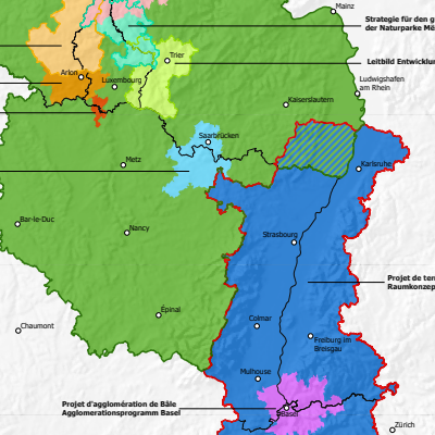
Cross-border spatial planning documents for the Greater Region and the Upper Rhine - 2024
Map showing the boundaries of the various cross-border planning documents for the Greater Region and the Upper Rhine, at sub-regional level.
Simple
- Date (Creation)
- 2024-06-01
- Date (Publication)
- 2024-06-10
- Citation identifier
- Amenag_transfrontalier_grenzueberschreitende_Raumplanung_GR_RS_2024
- Status
- Completed
- Point of contact
-
Organisation name Individual name Electronic mail address Role GeoRhena
GeoRhena
Processor SIG-GR - Ministère du Logement et de l'Aménagement du territoire - Département de l'aménagement du territoire
Processor
- Maintenance and update frequency
- Not planned
- Keywords
-
-
Map
-
- Keywords
-
-
Upper Rhine
-
Greater Region
-
-
GEMET - Concepts, version 2.4
-
-
administrative boundary
-
geography
-
co-operation policy
-
land setup
-
- Use limitation
-
Licence CC BY
- Access constraints
- Other restrictions
- Use constraints
- Other restrictions
- Other constraints
-
No other limitation
- Denominator
- 1000000
- Language
- Français
- Character set
- UTF8
- Topic category
-
- Planning cadastre
- Begin date
- 2023-01-01
- End date
- 2024-12-31
- Distribution format
-
Name Version PDF Map
-
- OnLine resource
-
Protocol Linkage Name WWW:DOWNLOAD-1.0-http--download https://www.georhena.eu/sites/default/files/Cartes/Amenag_transfrontalier_grenzueberschreitende_Raumplanung_GR_RS_2024.pdf Pdf Download
WWW:LINK-1.0-http--link https://geocatalogue.gis-gr.eu/geonetwork/gis-gr/fre/catalog.search#/metadata/4ec1dfc5-83a6-4059-86e2-a43b36d0d60f Additional metadata sheet
- Statement
-
Sources: GeoRhena, MDI Rheinland-Pfalz, MIBS Saarland, Ministerium der Deutschsprachigen Gemeinschaft, MLOGAT-DATer Luxembourg, Région Grand Est, Service public de Wallonie, Verband Rhein-Neckar 2024. Harmonization: GIS-GR 2024
Metadata
- File identifier
- 518266e3-b90a-44ea-8019-c0cc1c825201 XML
- Metadata language
- Français
- Character set
- UTF8
- Hierarchy level
- Static map
- Hierarchy level name
-
Carte statique
- Date stamp
- 2024-06-10T14:15:20.884022Z
- Metadata standard name
-
ISO 19115:2003/19139
- Metadata standard version
-
1.0
- Metadata author
-
Organisation name Individual name Electronic mail address Role GeoRhena: Geographical Information System of the Upper Rhine
Author
- Other language
-
Language Character encoding German UTF8 English UTF8 French UTF8
)
