 Demo Catalogue powered by geOrchestra
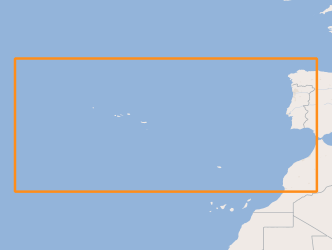
METAREA II Portugal
Limits used for the issuance of Meteorological Forecast Reports for Maritime Navigation in the areas of sea of national responsibility (Mainland Portugal, Azores and Madeira), inserted mainly in METAREA II, according to the standards defined by the Global Maritime Distress and Safety System (GMDSS).
Simple
- Date (Creation)
- 2017-01-04
- Citation identifier
- http://ipma.pt/boundaries/meteorology/cdg / 5e6e2b7b-a6b4-4742-af6a-89d91e561b11
- Citation identifier
- metareas
- Credit
-
World Meteorological Organization
- Point of contact
-
Organisation name Individual name Electronic mail address Role Instituto Português do Mar e da Atmosfera, I.P. (IPMA, I.P.)
Divisão de Previsão Meteorológica, Vigilância e Serviços Espaciais
Point of contact World Meteorological Organization (WMO)
Author
- Maintenance and update frequency
- Not planned
-
GEMET - INSPIRE themes, version 1.0
-
-
Zonas de gestão/restrição/regulamentação e unidades de referência
-
-
Thesaurus SNIMar v.1.0
-
-
Controlo do tráfego marítimo (VTS)
-
-
Thesaurus SNIMar v.1.0
-
-
Navegação, Tráfego e Segurança Marítima
-
-
Thesaurus SNIMar v.1.0
-
-
Limites Estabelecidos por Lei ou Convenção
-
-
Thesaurus SNIMar v.1.0
-
-
Meteorologia Marinha
-
- Keywords
-
-
IPMA, I.P.
-
- Use limitation
-
Sem restrições
- Access constraints
- Other restrictions
- Use constraints
- Other restrictions
- Other constraints
-
O acesso à informação está sujeito a pedido formal ao distribuidor oficial.
- Other constraints
-
O utilizador deve referir, sempre, a fonte de informação (WMO).
- Other constraints
-
O utilizador pode utilizar os dados para uso pessoal ou público desde que dessa utilização não decorram finalidades lucrativas ou ofensivas.
- Spatial representation type
- Vector
- Denominator
- -1
- Language
- Portuguese
- Character set
- UTF8
- Topic category
-
- Climatology, meteorology, atmosphere
- Oceans
))
- Reference system identifier
- EPSG / http://www.opengis.net/def/crs/EPSG/0/4258
- Reference system identifier
- EPSG / http://www.opengis.net/def/crs/EPSG/0/4326
- Distribution format
-
Name Version SHP
não se aplica
- Distributor contact
-
Organisation name Individual name Electronic mail address Role World Meteorological Organization (WMO)
Distributor
- OnLine resource
-
Protocol Linkage Name http://maps.ipma.pt/mapserv?map=/var/www/maps/boundaries/meteorology/metareas_wms.map
- Hierarchy level
- Dataset
Extent
- Dataset
-
5e6e2b7b-a6b4-4742-af6a-89d91e561b11
- Dataset
-
metareas
Conformance result
- Date (Publication)
- 2010-12-08
- Explanation
-
Ver a especificação citada.
- Pass
- No
- Statement
-
Resource created using information in WMS's publication "WMO No. 9 - WEATHER REPORTING VOLUME D - INFORMATION FOR SHIPPING" ( http://www.wmo.int/pages/prog/www/ois/Operational_Information/VolumeD/GMDSS/maps/2/SA_PRT.pdf ).
Metadata
- File identifier
- 4e5fbbd7-af90-4d2a-9166-9990ff289324 XML
- Metadata language
- Portuguese
- Character set
- UTF8
- Hierarchy level
- Dataset
- Date stamp
- 2017-04-12
- Metadata standard name
-
Perfil SNIMar
- Metadata standard version
-
v.0.9.3
- Metadata author
-
Organisation name Individual name Electronic mail address Role Instituto Português do Mar e da Atmosfera, I.P. (IPMA, I.P.)
Point of contact
- Other language
-
Language Character encoding English UTF8
Overviews
Spatial extent
Provided by
