 Demo Catalogue powered by geOrchestra
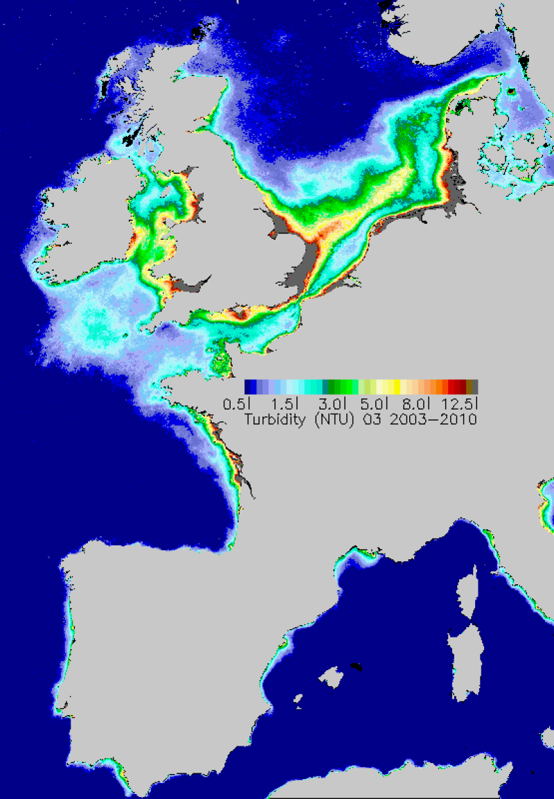
Données de turbidité satellite
Données de turbidité satellite
Cartes mensuelles moyennes de turbidité réalisées sur la période 2003-2010. La turbidité est estimée à partir des concentrations en matières en suspension inorganiques et de la chlorophylle-a.
Average monthly turbidity maps made during the period 2003-2010. Turbidity is estimated from the concentrations of inorganic suspended materials and chlorophyll-a.
Simple
-
Autres appellations ou acronymesAlternate title
-
Turbidité
Turbidity
-
Date (Creation)Date (Création)
- 2011-09-14T17:05:00
-
Citation identifierIdentificateur
- IFR_Turbidite
-
Citation identifierIdentificateur
- DOI:10.12770/49d5eaf6-172d-4487-8e9f-cb6564bee031
-
Presentation formForme de la présentation
-
Digital mapCarte numérique
-
Autres informations de référence
-
MODIS/NASA capteur AQUA
-
Reconnaissance
-
NASA, Marcoast, Myocean
-
StatusEtat
-
CompletedFinalisé
- Point of contact
-
Organisation name Individual name Electronic mail address Role Ifremer
Gohin Francis
AuthorAuteurACRI-ST
Bryère Philippe
AuthorAuteurIfremer
PublisherEditeur (publication)
-
Maintenance and update frequencyFréquence de mise à jour
-
As neededLorsque nécessaire
-
Thèmes Sextant
-
-
/Imagerie/Imagerie satellitale
/Imagery/Satellite Imagery
-
-
GEMET - INSPIRE themes, version 1.0
-
-
Caractéristiques géographiques océanographiques
-
-
external.theme.gemet
-
-
turbidité
Oceanographic geographical features
-
-
ThemeThème
-
-
turbidité
Turbidity
-
Satellite
-
Données ouvertes
-
Open Data
-
-
GEMET - INSPIRE themes, version 1.0
-
-
Caractéristiques géographiques océanographiques
Oceanographic geographical features
-
-
DCSMM : Descripteurs
-
-
D7: Changements hydrographiques
D7: Hydrographical Conditions
-
D5: Eutrophisation
D5: Eutrophication
-
-
Sous-regions marines
-
-
/Métropole
-
/Métropole/Golfe de Gascogne
Bay of Biscay
-
/Métropole/Manche mer du Nord
Channel-North Sea
-
/Métropole/Méditerranée occidentale
Western Mediterranean
-
/Métropole/Mers Celtiques
Celtic Seas
-
-
Cadre Réglementaire - SIMM
-
-
Directive Cadre pour la Planification de l'Espace Maritime (DCPEM)
-
Directive Cadre Stratégie pour le Milieu Marin (DCSMM)
-
-
Thématiques - SIMM
-
-
/Etat du Milieu/Biogéochimie
-
-
Limitation d'utilisation
-
Conditions inconnues
-
Access constraintsContraintes d'accès
-
Other restrictionsAutres restrictions
-
Autres contraintes
-
Not documented
-
Spatial representation typeType de représentation spatiale
-
GridRaster
-
DistanceDistance de résolution
- 1200 m
-
LanguageLangue de la ressource
- Français
-
LanguageLangue de la ressource
- English
-
Character setEncodage des caractères
-
UTF8Utf8
-
Topic categoryCatégorie ISO
-
-
OceansOcéans
-
-
Description de l'environnement de travail
-
Microsoft Windows XP ; ESRI ArcGIS 9.x
-
Geographic identifierIdentifiant géographique
- Plateau Ouest-Européen
- Begin date
- 2003-01-01T11:32:00
- End date
- 2010-12-31T09:00:00
))
-
Informations supplémentairesSupplemental Information
-
Gohin, F.: Annual cycles of Chlorophyll-a, non-algal Suspended Particulate Matter and Turbidity observed from space and in-situ in coastal waters, in revision in Ocean Science, ECOOP (European COastal sea OPerational observing and forecasting system) special issue
Gohin, F.: Annual cycles of Chlorophyll-a, non-algal Suspended Particulate Matter and Turbidity observed from space and in-situ in coastal waters, in revision in Ocean Science, ECOOP (European COastal sea OPerational observing and forecasting system) special issue
-
Reference system identifierNom du système de référence
-
WGS 84 (EPSG:4326)
-
Number of dimensionsDimensions
- 2
-
Dimension nameNoms des axes
-
ColumnAxe - X
-
Dimension sizeNombre de pixel
- 1667
-
ResolutionRésolution
- 0.015 degree
-
Dimension nameNoms des axes
-
RowAxe - Y
-
Dimension sizeNombre de pixel
- 2401
-
ResolutionRésolution
- 0.01 degree
-
Cell geometryType de raster
-
AreaSurface
-
Transformation parameter availabilityDisponibilité des paramètres de transformation
- No
Distributor
Distributeur
- Distributor contact
-
Organisation name Individual name Electronic mail address Role Ifremer - Centre de Brest
DistributorDistributeur
- Distributor format
-
Name Version GeoTIFF
Aldus TIFF 6.0 spec (TIFF version 42)
- OnLine resource
-
Protocol Linkage Name OGC:WMS-1.3.0-http-get-map
https://sextant.ifremer.fr/services/wms/oceanographie_physique turbidity_2003_2010_01
COPYFILE
turbidity_2003_2010_01
- OnLine resource
-
Protocol Linkage Name OGC:WMS-1.3.0-http-get-map
https://sextant.ifremer.fr/services/wms/oceanographie_physique turbidity_2003_2010_02
COPYFILE
turbidity_2003_2010_02
- OnLine resource
-
Protocol Linkage Name OGC:WMS-1.3.0-http-get-map
https://sextant.ifremer.fr/services/wms/oceanographie_physique turbidity_2003_2010_03
COPYFILE
turbidity_2003_2010_03
- OnLine resource
-
Protocol Linkage Name OGC:WMS
https://sextant.ifremer.fr/services/wms/oceanographie_physique turbidity_2003_2010_04
COPYFILE
turbidity_2003_2010_04
- OnLine resource
-
Protocol Linkage Name OGC:WMS
https://sextant.ifremer.fr/services/wms/oceanographie_physique turbidity_2003_2010_05
COPYFILE
turbidity_2003_2010_05
- OnLine resource
-
Protocol Linkage Name OGC:WMS
https://sextant.ifremer.fr/services/wms/oceanographie_physique turbidity_2003_2010_06
COPYFILE
turbidity_2003_2010_06
- OnLine resource
-
Protocol Linkage Name OGC:WMS
https://sextant.ifremer.fr/services/wms/oceanographie_physique turbidity_2003_2010_07
COPYFILE
turbidity_2003_2010_07
- OnLine resource
-
Protocol Linkage Name OGC:WMS
https://sextant.ifremer.fr/services/wms/oceanographie_physique turbidity_2003_2010_08
COPYFILE
turbidity_2003_2010_08
- OnLine resource
-
Protocol Linkage Name OGC:WMS
https://sextant.ifremer.fr/services/wms/oceanographie_physique turbidity_2003_2010_09
COPYFILE
turbidity_2003_2010_09
- OnLine resource
-
Protocol Linkage Name OGC:WMS
https://sextant.ifremer.fr/services/wms/oceanographie_physique turbidity_2003_2010_10
COPYFILE
turbidity_2003_2010_10
- OnLine resource
-
Protocol Linkage Name OGC:WMS
https://sextant.ifremer.fr/services/wms/oceanographie_physique turbidity_2003_2010_11
COPYFILE
turbidity_2003_2010_11
- OnLine resource
-
Protocol Linkage Name OGC:WMS
https://sextant.ifremer.fr/services/wms/oceanographie_physique turbidity_2003_2010_12
COPYFILE
turbidity_2003_2010_12
- OnLine resource
-
Protocol Linkage Name WWW:LINK-1.0-http--metadata-URL
http://doi.org/10.12770/49d5eaf6-172d-4487-8e9f-cb6564bee031
-
Hierarchy levelNiveau
-
DatasetJeu de données
Conformance result
Résultat de conformité
-
Titre
-
INSPIRE
-
Date (Publication)Date (Publication)
- 2007-03-14
-
ExplicationExplanation
-
Non évalué
Not evaluated
-
PassDegré de conformité
- No
-
Généralités sur la provenanceStatement
-
Turbidity derived from non algal MES and Chlorophyll-a of MODIS/AQUA averaged monthly from January 2003 to December 2010. MODIS data reprocessing NASA 2011
Turbidity derived from non algal MES and Chlorophyll-a of MODIS/AQUA averaged monthly from January 2003 to December 2010. MODIS data reprocessing NASA 2011
-
DescriptionDescription
-
Turbidity calculated from non algal MES and Chlorophyll-a estimated by the Ifremer algorithms applied to MODIS. Method developed in Ifremer report:wwz.ifremer.fr/dcsmm/.../DCSMM_rapport-tsm-chl-turb_ifremer-janv2011-V1.pdf
Turbidity calculated from non algal MES and Chlorophyll-a estimated by the Ifremer algorithms applied to MODIS. Method developed in Ifremer report:wwz.ifremer.fr/dcsmm/.../DCSMM_rapport-tsm-chl-turb_ifremer-janv2011-V1.pdf
Metadata
-
File identifierIdentifiant de la fiche
- 49d5eaf6-172d-4487-8e9f-cb6564bee031 XML
-
Metadata languageLangue
- Français
-
Character setJeu de caractères
-
UTF8Utf8
-
Hierarchy levelType de ressource
-
DatasetJeu de données
-
Date stampDate des métadonnées
- 2020-06-04T00:24:13
- Metadata standard name
-
ISO 19115:2003/19139 - SEXTANT
- Metadata standard version
-
1.0
- Metadata author
-
Organisation name Individual name Electronic mail address Role Ifremer
Gohin Francis
Point of contactPoint de contactACRI-ST
Philippe Bryère
Point of contactPoint de contact
- Other language
-
Language Character encoding EnglishAnglaisFrenchFrançaisUTF8Utf8
)))
