 Demo Catalogue powered by geOrchestra
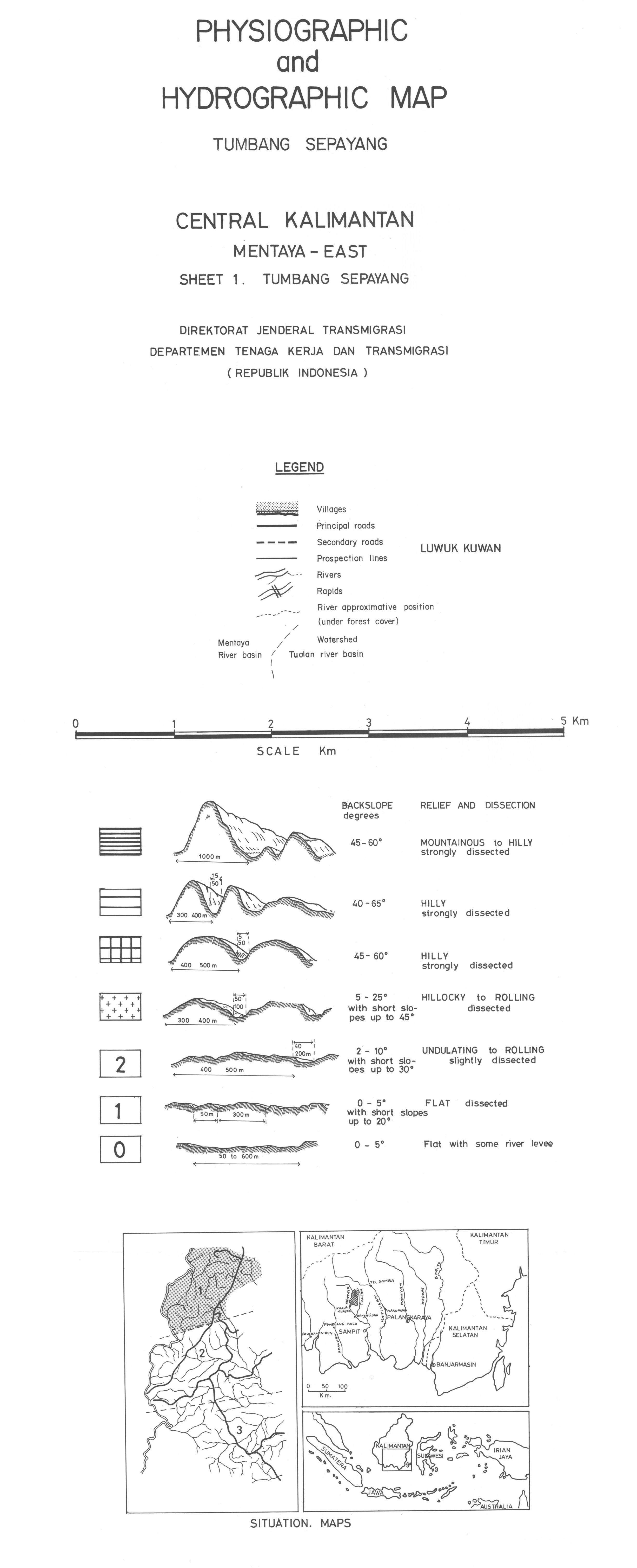
Central Kalimantan : Mentaya-East : Tumbang Sepayang : physiographic and hydrographic map. Scale of 1:20 833. Date of publication: 1981-1982.
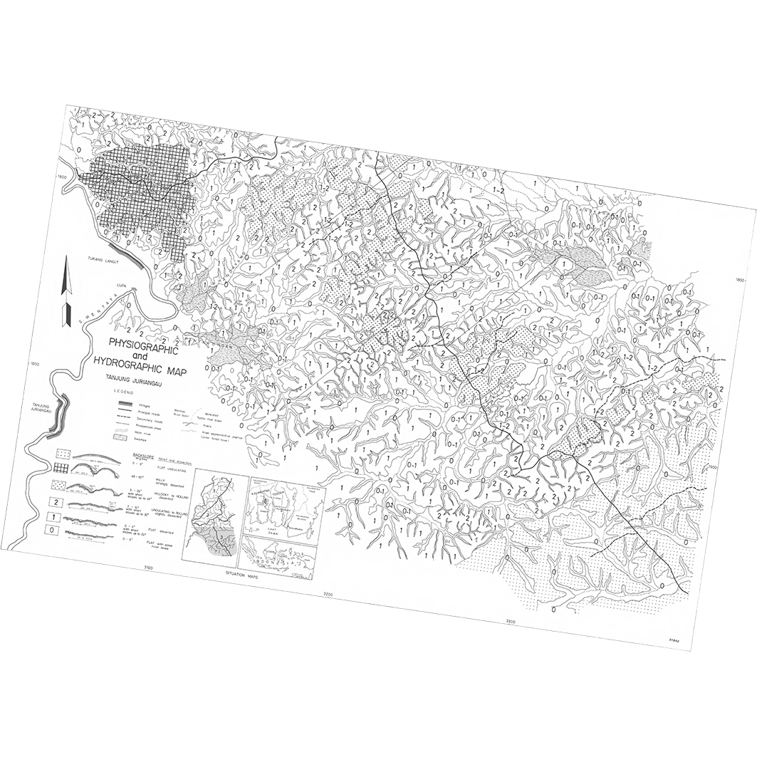
1. Physiographic and hydrographic map : Tanjung Juriangau : Central Kalimantan : Mentaya-East : sheet 3. / Sieffermann, G.; Bambang, D.S. (ill.); Bambang, H.; Budianto, T.; Djoko Pudjiono (ill.); Levang, P.; Marten, R.; Mujidin; Sevin, O.; Sudarmadji; Sudirman; Supoyo, R.; Scale of 1:20 833. Date of publication: 1981. (file: 01842RC_IRD_IDN_EVPH_1981_20833_IRD_IDN_EVPH_1981-82_20833.tif)
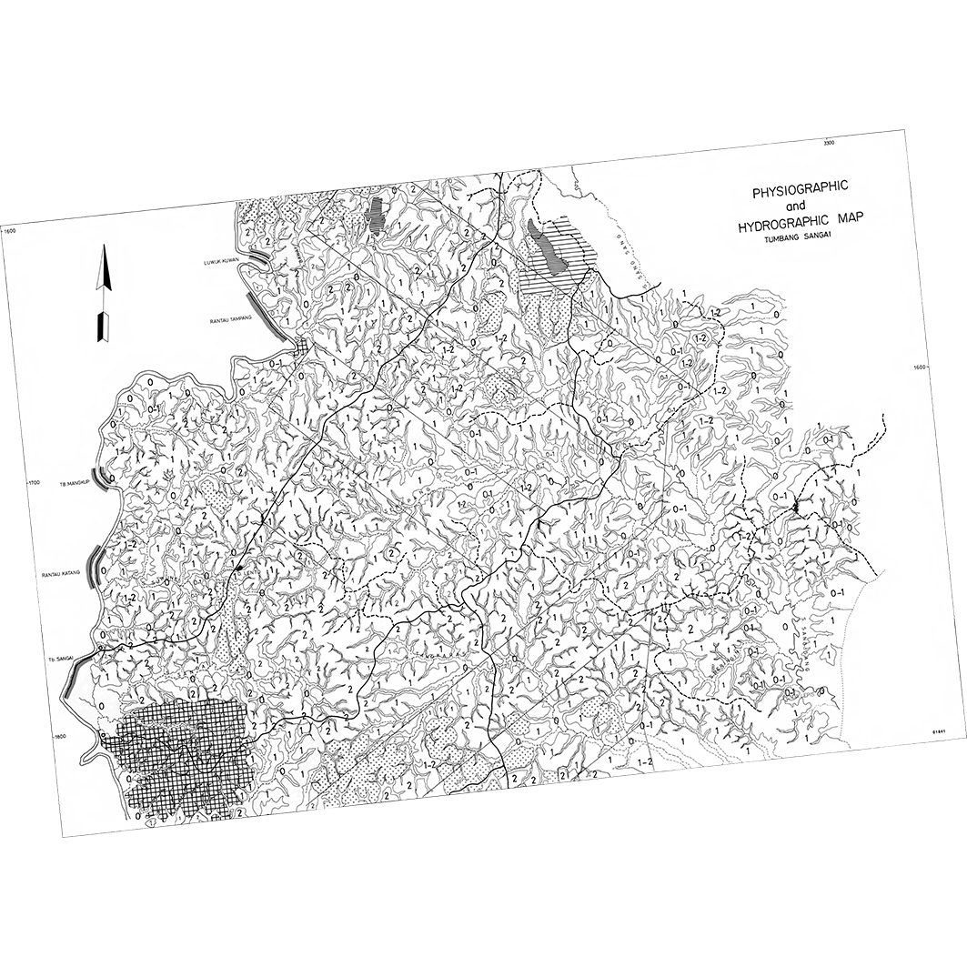
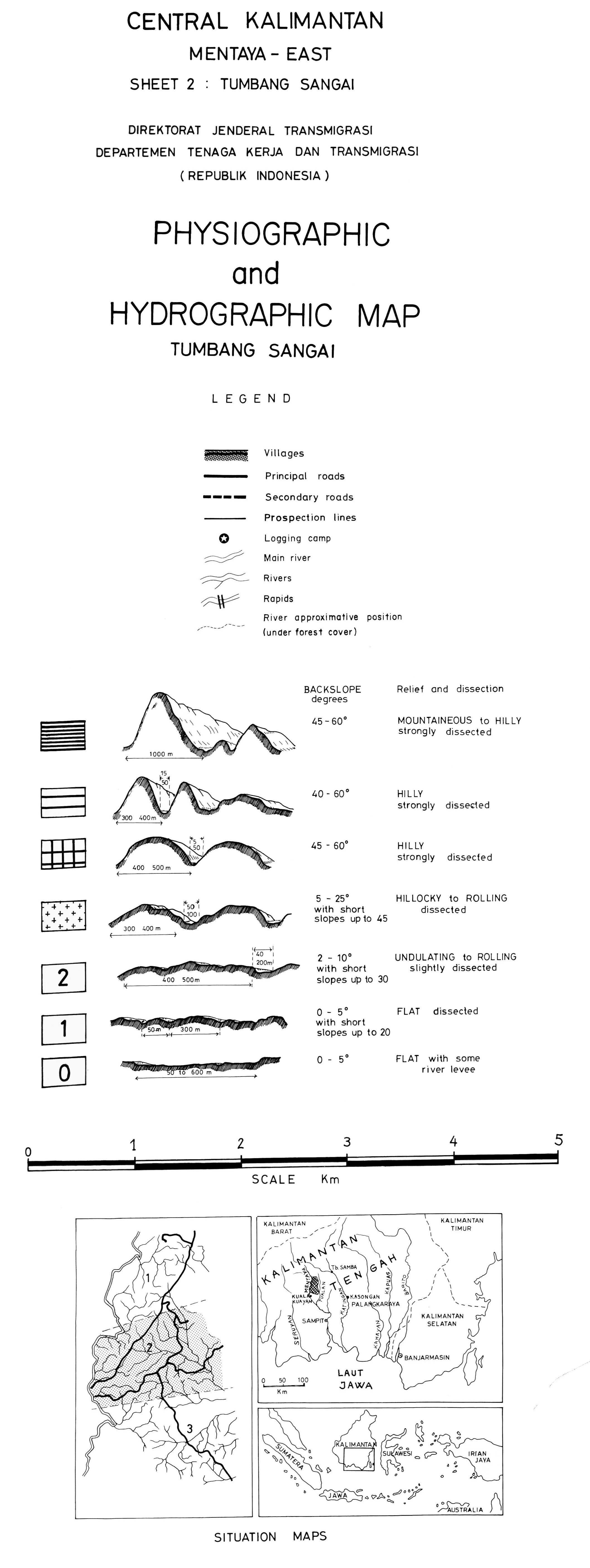
2. Physiographic and hydrographic map : Tumbang Sangai : Central Kalimantan : Mentaya-East : sheet 2. / Sieffermann, G.; Bambang, D.S. (ill.); Bambang, H.; Budianto, T.; Levang, P.; Marten, R.; Mujidin; Sevin, O.; Sudarmadji; Sudarno (ill.); Sudirman; Supoyo, R.; Scale of 1:20 833. Date of publication: 1982. (file: 01841RC_IRD_IDN_EVPH_1982_20833_IRD_IDN_EVPH_1981-82_20833.tif)
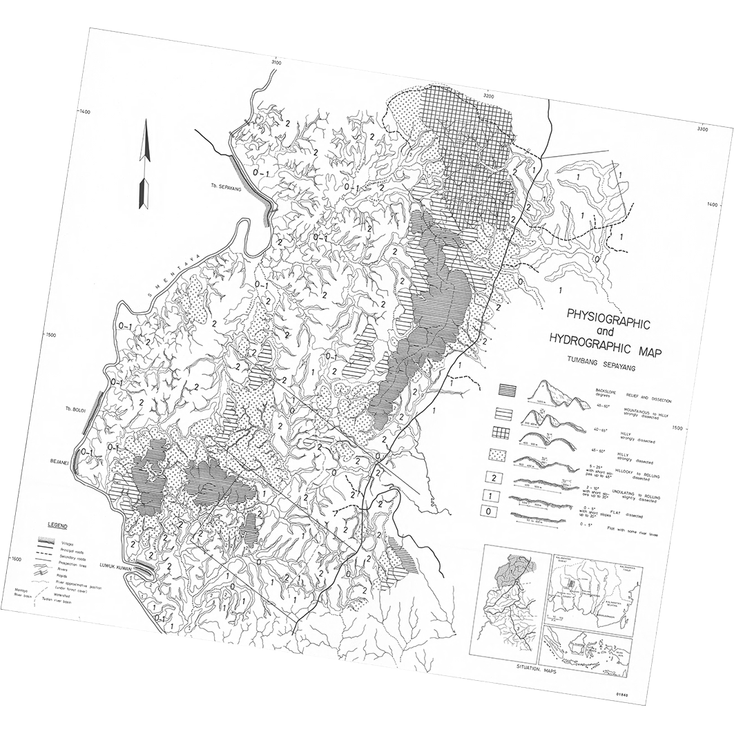
3. Physiographic and hydrographic map : Tumbang Sepayang : Central Kalimantan : Mentaya-East : sheet 1. / Sieffermann, G.; Bambang, D.S. (ill.); Bambang, H.; Budianto, T.; Djoko Pudjiono (ill.); Levang, P.; Marten, R.; Mujidin; Sevin, O.; Sudarmadji; Sudirman; Supoyo, R.; Scale of 1:20 833. Date of publication: 1981. (file: 01840RC_IRD_IDN_EVPH_1981_20833_IRD_IDN_EVPH_1981-82_20833.tif)
Simple
- Date (Publication)
- 1981-01-01
- Citation identifier
- IRD_IDN_EVPH_1981-82_20833
- Credit
-
The region Île-de-France, under the project NumeriSud, supported the action to transforme around 2800 maps that are conserved at the Institut de recherche pour le développement (IRD) library in Bondy into a standard coordinate system. The transformation of the images has been done by Global Mapping Resources (South Africa) under the supervision of R. Zaiss (éditeur) 2014.
- Status
- Completed
- Point of contact
-
Organisation name Individual name Electronic mail address Role Institut de recherche pour le développement (IRD)
Production cartographique IRD
Point of contact Sieffermann, G.
Author Bambang, D.S. (ill.)
Author Bambang, H.
Author Budianto, T.
Author Djoko Pudjiono (ill.)
Author Levang, P.
Author Marten, R.
Author Mujidin
Author Sevin, O.
Author Sudarmadji
Author Sudarno (ill.)
Author Sudirman
Author Supoyo, R.
Author Direktorat Jenderal Transmigrasi, Departemen Tenaga Kerja dan Transmigrasi
editor ORSTOM, Office de la recherche scientifique et technique outre-mer
editor
- Maintenance and update frequency
- Not planned
-
Geounits
-
-
Asia
-
South-Eastern Asia
-
Indonesia
-
- Theme
-
-
thematic map
-
- Keywords
-
-
project NumeriSud
-
local coverage
-
- Use limitation
-
Licence : CC-BY-NC-SA
- Access constraints
- licence
- Classification
- Unclassified
- Spatial representation type
- Grid
- Denominator
- 20833
- Language
- Français
- Character set
- UTF8
- Topic category
-
- Geoscientific information
))
- Begin date
- 1981-01-01
- End date
- 1982-12-31
- Supplemental Information
-
Publication(s):
Sieffermann, G., Marten, R., Sudirman, S., Levang, P., Bambang, H., Sevin, O., Sudarmadji, Budianto, T., Supoyo, R., Mujidin (1981-1982): East Mentaya priority area central Kalimantan : phase 2 report (part. 1) : the physical environment. Jakarta (IDN) : Direktorat Jenderal Transmigrasi, Departemen Tenaga Kerja dan Transmigrasi ; Paris (FRA) : ORSTOM, Office de la recherche scientifique et technique outre mer.
Sieffermann, G., Sudirman, S., Marten, R., Bambang, H., Levang, P., Supoyo, R., Budianto, T., Mujidin, Sudarmadji, Sevin, O. (1981): East Mentaya priority area central Kalimantan : phase 2 report (part. 1) : the physical environment. Jakarta (IDN) : Direktorat Jenderal Transmigrasi, Departemen Tenaga Kerja dan Transmigrasi ; Paris (FRA) : ORSTOM, Office de la recherche scientifique et technique outre mer.
- Reference system identifier
- EPSG / 4326 / 7.9
- Distribution format
-
Name Version GeoTIFF
1.0
- Distributor contact
-
Organisation name Individual name Electronic mail address Role DataSuds-geo
Publisher
- OnLine resource
-
Protocol Linkage Name OGC:WMS
https://datasuds-geo.ird.fr/geoserver/wms sphaera_ws:01842RC_IRD_IDN_EVPH_1981_20833_IRD_IDN_EVPH_1981-82_20833
WWW:DOWNLOAD:GeoTIFF https://datasuds-geo.ird.fr/geoserver/ows?service=WCS&version=2.0.1&request=GetCoverage&coverageId=01842RC_IRD_IDN_EVPH_1981_20833_IRD_IDN_EVPH_1981-82_20833 WWW:LINK-1.0-http--related
https://www.documentation.ird.fr/hor/fdi:02448 Notice explicative ou autre ouvrage
- OnLine resource
-
Protocol Linkage Name OGC:WMS
https://datasuds-geo.ird.fr/geoserver/wms sphaera_ws:01841RC_IRD_IDN_EVPH_1982_20833_IRD_IDN_EVPH_1981-82_20833
WWW:DOWNLOAD:GeoTIFF https://datasuds-geo.ird.fr/geoserver/ows?service=WCS&version=2.0.1&request=GetCoverage&coverageId=01841RC_IRD_IDN_EVPH_1982_20833_IRD_IDN_EVPH_1981-82_20833 WWW:LINK-1.0-http--related
https://www.documentation.ird.fr/hor/fdi:02448 Notice explicative ou autre ouvrage
- OnLine resource
-
Protocol Linkage Name OGC:WMS
https://datasuds-geo.ird.fr/geoserver/wms sphaera_ws:01840RC_IRD_IDN_EVPH_1981_20833_IRD_IDN_EVPH_1981-82_20833
WWW:DOWNLOAD:GeoTIFF https://datasuds-geo.ird.fr/geoserver/ows?service=WCS&version=2.0.1&request=GetCoverage&coverageId=01840RC_IRD_IDN_EVPH_1981_20833_IRD_IDN_EVPH_1981-82_20833 WWW:LINK-1.0-http--related
https://www.documentation.ird.fr/hor/fdi:02448 Notice explicative ou autre ouvrage
- OnLine resource
-
Protocol Linkage Name DOI
https://doi.org/10.23708/42f1fe85-1800-4a45-86dc-6527fe73b68b Digital Object Identifier (DOI)
- Hierarchy level
- Dataset
- Statement
-
1. Scanning to tif format, 256 colors, 250dpi.
2. Georeferencing and if possible reprojection to WGS84 (Longitude / Latitude).
3. Clipping and mosaicing of map sheets(s).
4. Export ECW format.
5. ECW to GeoTIFF format conversion.
Metadata
- File identifier
- 42f1fe85-1800-4a45-86dc-6527fe73b68b XML
- Metadata language
- English
- Character set
- UTF8
- Hierarchy level
- Dataset
- Hierarchy level name
-
dataset
- Date stamp
- 2024-02-13T18:42:31.48149Z
- Metadata standard name
-
ISO 19115:2003/19139
- Metadata standard version
-
1.0
- Metadata author
-
Organisation name Individual name Electronic mail address Role Institut de recherche pour le développement (IRD)
Service de l'Information Scientifique et Technique (IST) IRD
Point of contact Institut de recherche pour le développement (IRD)
IRD
Resource provider
Overviews

Spatial extent
Provided by
