 Demo Catalogue powered by geOrchestra
Rejeu hydrodynamique à 500 m de résolution avec le modèle MARS3D-AGRIF - Zone Manche-Gascogne
Inter annual hydrodynamic hindcast with MARS3D-AGRIF model - Bay of biscay and Manche Areas
'''Résumé:'''
Base de donnée hydrodynamique réalisée avec le modèle MARS3D et la librairie AGRIF (V10.10) le long de la façade atlantique française à la résolution spatiale de 500m et à la fréquence horaire.
''' Description détaillée '''
Les cartes prédictives d’habitats benthiques sont établies à partir de modèles statistiques qui se nourrissent de données décrivant la contrainte sur le fond (vague et courant) et les conditions de température et salinité. Ces statistiques se basent sur des simulations de modèles réalistes à l’échelle inter annuelle. Les données jusqu’ici utilisées, s’appuyaient sur les archives du modèle opérationnel Manche-Gascogne à 2500m construit dans le cadre du projet PREVIMER ( http://www.previmer.org )
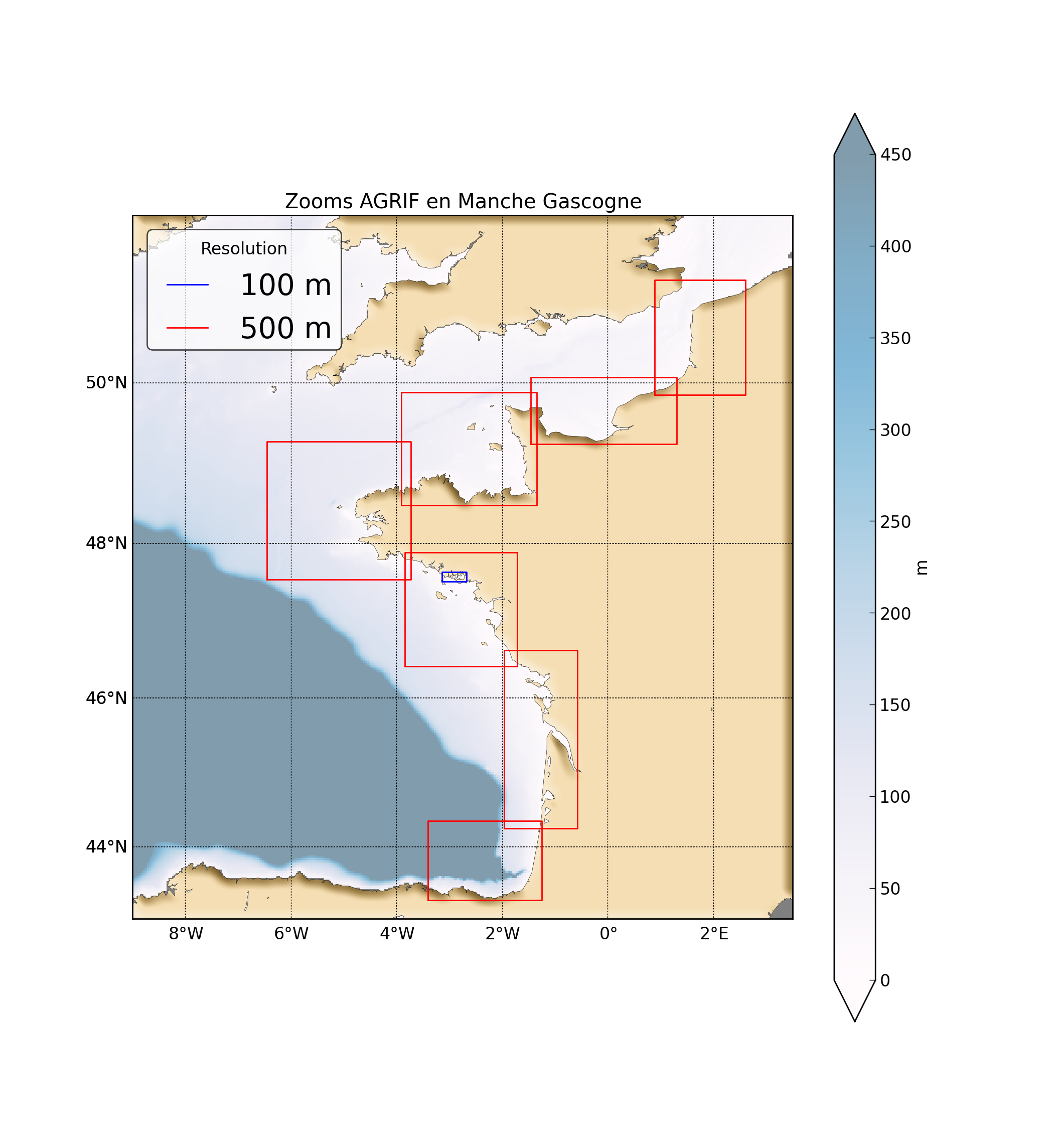
La mise en place de zooms avec la librairie AGRIF ( http://www-ljk.imag.fr/MOISE/AGRIF/ ) le long de la façade atlantique a permis d’augmenter la résolution à 500m et localement à 100m (Golfe du Morbihan). Le travail consistait alors à produire un rejeu sur cinq ans avec l’ensemble des zooms pour établir des climatologies en zone côtière à haute résolution.
Une simulation de six années allant de 2010 à 2015 a été réalisée pour l’ensemble des emprises couvrant la façade atlantique.
''' Caractéristiques des simulations '''
Résolution spatiale horizontale : 500 m sur toute la façade atlantique+ 100m dans le Golfe du Morbihan
Résolution spatiale verticale : 40 niveaux (Sigma généralisés)
Résolution temporelle : 1H
'''Paramètres calculés :'''
Variables 2D disponibles : Élévation de la surface libre, Vitesses barotropes (U,V)
Variables 3D disponibles : Température, Salinité, Vitesses
"Abstract: "
Hydrodynamic database build with the MARS3D model along the french manche and atlantic coast at high spatial (500m) and temporal (1h) resolution
"Details:"
Seabed habitats maps are build from statistics models which need some data that describe the physical
environment of the different species. Theses environmental factors are the salinity, temperature and
shear stress (from waves and current) on the sea floor. Statistics are based on realistic and inter-annual
simulations from 3D ocean models.Models output are currently available at a uniform resolution of 2.5 km along the whole French coast,as a part of the PREVIMER project ( http://www.previmer.org )
To increase the horizontal resolution of the model to 500m grid spacing, an on-line grid refinement
technique has been carried out with the AGRIF library. ( http://www-ljk.imag.fr/MOISE/AGRIF/ )
Seven zooms (with 500m resolution) have been implemented in the 2.5 km MANGAE configuration.
From this configuration, an hindcast of six years (from 2010 to 2015) has been simulated and cover the french coast from spain to pas-de-calais area :
"Main features of the hindcast"
Horizontal resolution : 500m
Vertical resolution : 40 sigma levels
Temporal resolution : 1 Hour
"Available physical parameters"
◦ 2D : Sea surface height and barotropic velocities (U and V components)
◦ 3D : Temperature, Salinity and baroclinic velocities
Simple
-
Date (Publication)Date (Publication)
- 2016-09-21
-
Citation identifierIdentificateur
- FR-330-715-368-00032-IFR_F_HYDRO_MARS3D_500M
-
Citation identifierIdentificateur
- DOI:10.12770/3edee80f-5a3e-42f4-9427-9684073c87f5
-
ReconnaissanceCredit
-
IFREMER-DYNECO
IFREMER-DYNECO
- Point of contact
-
Organisation name Individual name Electronic mail address Role Ifremer
Caillaud Matthieu
PublisherEditeur (publication)Ifremer
Caillaud Matthieu
AuthorAuteurIfremer
Petton Sebastien
AuthorAuteurIfremer
Dumas Franck
AuthorAuteurIfremer
Rochette Sebastien
AuthorAuteurIfremer
Vasquez Mickael
AuthorAuteur
-
Thèmes Sextant
-
-
/Milieu physique/Hydrodynamique côtière
/Physical Environment/Coastal Hydrodynamics
-
-
GEMET - INSPIRE themes, version 1.0
-
-
Caractéristiques géographiques océanographiques
Oceanographic geographical features
-
-
ThemeThème
-
-
hydrodynamique
hydrodynamic
-
modélisation
modelling system
-
-
Sous-regions marines
-
-
/Métropole/Golfe de Gascogne
Bay of Biscay
-
/Métropole/Manche mer du Nord
Channel-North Sea
-
/Métropole/Mers Celtiques
Celtic Seas
-
-
DCSMM : Descripteurs
-
-
D1: Biodiversité - Habitats benthiques
D1: Coastal benthic habitats
-
D3: Espèces commerciales
D3: Commercially Exploited Species
-
D5: Eutrophisation
D5: Eutrophication
-
D6: Intégrité des fonds marins
D6: Sea-floor Integrity
-
D7: Changements hydrographiques
D7: Hydrographical Conditions
-
D10: Déchets marins
D10: Marine Litter
-
-
Cadre Réglementaire - SIMM
-
-
Directive Cadre Stratégie pour le Milieu Marin (DCSMM)
-
Directive Cadre pour la Planification de l'Espace Maritime (DCPEM)
-
-
Thématiques - SIMM
-
-
/Etat du Milieu/Hydrodynamique
-
-
Limitation d'utilisationUse limitation
-
Data are available on a mail request
Data are available on a mail request
-
Access constraintsContraintes d'accès
-
Other restrictionsAutres restrictions
-
Use constraintsContraintes d'utilisation
-
Other restrictionsAutres restrictions
-
Autres contraintesOther constraints
-
Citation du rejeu
Hindcast to quote in any publication
-
Spatial representation typeType de représentation spatiale
-
GridRaster
-
DistanceDistance de résolution
- 500 meter
-
LanguageLangue de la ressource
- Français
-
Character setEncodage des caractères
-
UTF8Utf8
-
Topic categoryCatégorie ISO
-
-
OceansOcéans
-
))
- Begin date
- 2010-01-01
- End date
- 2015-12-31
-
Reference system identifierNom du système de référence
-
EPSG
/
WGS 84 (EPSG:4326)WGS 84 (EPSG:4326)/ 8.6
- Distribution format
-
Name Version NetCDF
4
- OnLine resource
-
Protocol Linkage Name WWW:LINK-1.0-http--link
https://sextant.ifremer.fr/geonetwork/srv/api/records/3edee80f-5a3e-42f4-9427-9684073c87f5/attachments/hindcast_description.pdf Hindcast description
WWW:LINK
http://doi.org/10.12770/3edee80f-5a3e-42f4-9427-9684073c87f5 DOI du jeu de données
DOI of the dataset
-
Hierarchy levelNiveau
-
DatasetJeu de données
-
Généralités sur la provenanceStatement
-
Hindcast réalisé avec les données de forçage du CDOCO (météo du modèle Arôme). Validation avec mesures de courants radar HF & ADCP, satellites pour la SST et séries temporelles de stations côtières pour la température et salinité de surface. validation avec mesures MASTODON pour la température de fond.
This hindcast has been built with boundary conditions from MYOCEAN products, atmospheric forcing from the models of the French meteorological institute. A work of validation with various data (in situ, radar, satellite) from IFREMER's database has been carried out.
Process step
Evénement
Metadata
-
File identifierIdentifiant de la fiche
- 3edee80f-5a3e-42f4-9427-9684073c87f5 XML
-
Metadata languageLangue
- Français
-
Character setJeu de caractères
-
UTF8Utf8
-
Hierarchy levelType de ressource
-
SeriesCollection de données
-
Date stampDate des métadonnées
- 2021-08-16T16:23:59
- Metadata standard name
-
ISO 19115:2003/19139 - SEXTANT
- Metadata standard version
-
1.0
- Metadata author
-
Organisation name Individual name Electronic mail address Role Ifremer
Caillaud Matthieu
Point of contactPoint de contact
- Other language
-
Language Character encoding EnglishAnglaisFrenchFrançaisUTF8Utf8
Overviews
Spatial extent
Provided by
