 Demo Catalogue powered by geOrchestra
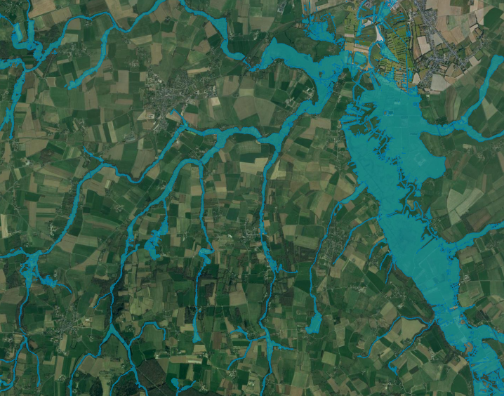
Potential wetlands (Couesnon watershed, 2016-2017) - Zone Atelier Armorique ZAAr
This map represents potential wetlands of the Couesnon watershed bottom valley at 1 : 25 000.
Potential wetlands correspond to the largest area that wetlands would represent without human activity and are characterized by a hydromorphic soil (Mérot et al., 2006).
A LiDAR-derived DTM (from IGN) and 107 soil samples were used to estimate an elevation threshold between hydromorphic and non-hydromorphic soil, according to the nearest stream Strahler order (Rapinel et al, 2017).
Simple
- Date (Publication)
- 2019-06
- Citation identifier
-
https://www.osuris.fr/geonetwork/srv/metadata/38ace42f-d82e-46b2-8fcf-622ddad20f2c
- Status
- Under development
- Point of contact
-
Organisation name Individual name Electronic mail address Role LETG-RENNES UMR 6554 CNRS Université de Rennes 2
Elodie Fabre
Author LETG-RENNES UMR 6554 CNRS Université de Rennes 2
Sebastien Rapinel
Author
- Maintenance and update frequency
- As needed
- Theme
-
-
Zone humide potentielle
-
Couesnon
-
Environnement
-
Potential wetlands
-
- Place
-
-
Zone Atelier Armorique ZAAr
-
-
GEMET - INSPIRE themes, version 1.0
-
-
Sols
-
Habitats et biotopes
-
Hydrographie
-
- Use limitation
-
Utilisation libre sous réserve de mentionner la source (a minima le nom du producteur) et la date de sa dernière mise à jour
- Use limitation
-
Usage libre sous réserve des mentions obligatoires sur tout document de diffusion : "Source : {Unité de recherche}""
- Access constraints
- Copyright
- Use constraints
- Restricted
- Spatial representation type
- Vector
- Denominator
- 25000
- Language
- English
- Character set
- UTF8
- Topic category
-
- Environment
- Begin date
- 2018-04-01T00:00:00
- End date
- 2018-04-01T00:00:00
))
- Distribution format
-
Name Version ESRI Shapefile
{version si connue}
- Distributor contact
-
Organisation name Individual name Electronic mail address Role OSUR
OSUR
Point of contact
- OnLine resource
-
Protocol Linkage Name OGC:WMS-1.3.0-http-get-capabilities
https://www.osuris.fr/geoserver/zaar/wms ZH_potentielles
- Hierarchy level
- Dataset
Conformance result
- Date (Publication)
- 2018-06-29
- Explanation
-
conforme
- Pass
- Yes
- Statement
-
OSUR
Merot, P., Hubert-Moy, L., Gascuel-Odoux, C., Clement, B., Durand, P., Baudry, J., Thenail, C., 2006. A Method for Improving the Management of Controversial Wetland. Environmental Management 37, 258‑70. https://doi.org/10.1007/s00267-004-0391-4 .
Rapinel, S., Clément, B., Dufour, S., Hubert-Moy, L., 2017. Fine-Scale Monitoring of Long-Term Wetland Loss Using LiDAR Data and Historical Aerial Photographs: The Example of the Couesnon Floodplain, France. Wetlands,, 1‑13. https://doi.org/10.1007/s13157-017-0985- 2.
Metadata
- File identifier
- 38ace42f-d82e-46b2-8fcf-622ddad20f2c XML
- Metadata language
- Français
- Character set
- UTF8
- Hierarchy level
- Dataset
- Date stamp
- 2019-07-02T22:54:03
- Metadata standard name
-
ISO 19115:2003/19139
- Metadata standard version
-
1.0
- Metadata author
-
Organisation name Individual name Electronic mail address Role LETG-RENNES UMR 6554 CNRS Université de Rennes 2
Alban Thomas
Point of contact
Overviews
Spatial extent
Provided by
