 Demo Catalogue powered by geOrchestra
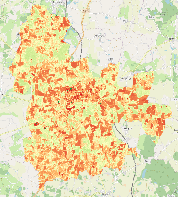
Carte du NDVI sur la commune de Combourg au 09/08/2022
Carte du NDVI (Normalized difference Vegetation Index) sur la commune de Combourg au 09/08/2022
Simple
- Alternate title
-
NDVI Combourg
- Date (Publication)
- 2022-11-25T14:00:00
- Edition
-
Continue
- Citation identifier
- fr-18007003900276-ppascal-ndvi_combourg
- Purpose
-
La carte du NDVi a été réalisée à partir de l'image Sentinel 2 du 09/08/2022. L'image avait un niveau de traitement 2A.
Les valeurs inférieures à 0 ont été ramenées à 0 et celles supérieures à 1 ramenées à 1.
- Status
- Completed
- Point of contact
-
Organisation name Individual name Electronic mail address Role Master TELENVI - Institut Agro
Pascal PICHELIN
Originator
- Maintenance and update frequency
- As needed
-
INSPIRE themes
-
-
Ortho-imagerie
-
- Keywords
-
-
Données ouvertes
-
-
GéoBretagne v 2.0
-
-
référentiels : imagerie
-
- Use limitation
-
Usage libre sous réserve des mentions obligatoires sur tout document de diffusion : "Source : UMR TETIS AgroParisTech Cirad CNRS INRAE"
- Use limitation
-
Licence ouverte : https://www.etalab.gouv.fr/licence-ouverte-open-licence
- Access constraints
- Other restrictions
- Use constraints
- License
- Other constraints
-
Pas de restriction d’accès public
- Spatial representation type
- Grid
- Distance
- 10 m
- Language
-
fre
- Topic category
-
- Environment
- Description
-
Série temporelle sur la Bretagne
))
- Reference system identifier
- EPSG:WGS 84 / UTM zone 30N. (EPSG:32630)
Distributor
- Distributor contact
-
Organisation name Individual name Electronic mail address Role UMR 1069 SAS INRA - Agrocampus Ouest
Pole GéoSAS
Distributor
- Distributor format
-
Name Version GeoTIFF
1.0
- OnLine resource
-
Protocol Linkage Name WWW:DOWNLOAD-1.0-http--download
https://geosas.fr/ensserver/ows?service=WCS&version=2.0.1&request=GetCoverage&coverageId=ppascal__Combourg_NDVI_20220809&format=geotiff OGC:WMS
https://geosas.fr/ensserver/ppascal/wms?SERVICE=WMS&REQUEST=GetCapabilities Combourg_NDVI_20220809
- Hierarchy level
- Dataset
Conformance result
- Date (Publication)
- 2022-06-17
- Explanation
-
Non Evalué
- Pass
- No
Metadata
- File identifier
- 3363a53e-d760-42cc-b5dc-a0fd28d49e09 XML
- Metadata language
-
fre
- Character set
- UTF8
- Hierarchy level
- Dataset
- Date stamp
- 2022-11-25T14:08:49
- Metadata standard name
-
ISO 19115
- Metadata standard version
-
1.0
- Metadata author
-
Organisation name Individual name Electronic mail address Role UMR 1069 SAS INRA - Agrocampus Ouest
Pole GéoSAS
Point of contact
Overviews
Spatial extent
Provided by
