 Demo Catalogue powered by geOrchestra
Mom : Terroir bassa (Cameroun). Scale of 1:20 000 to 1:10 000. Date of publication: 1972.
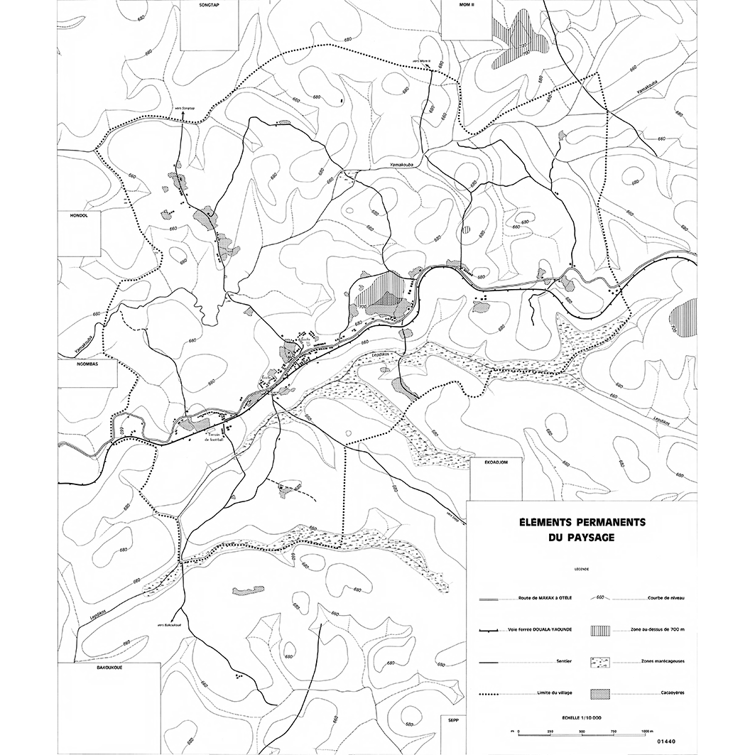
1. Mom : éléments permanents du paysage : carte No 1. / Champaud, Jacques; Amouzouvi, J. (ill.); Scale of 1:10 000. Date of publication: 1972. (file: 01440RC_IRD_CMR_AGPA_1972_10000_IRD_CMR_CSRE_1972_20000-10000.tif)
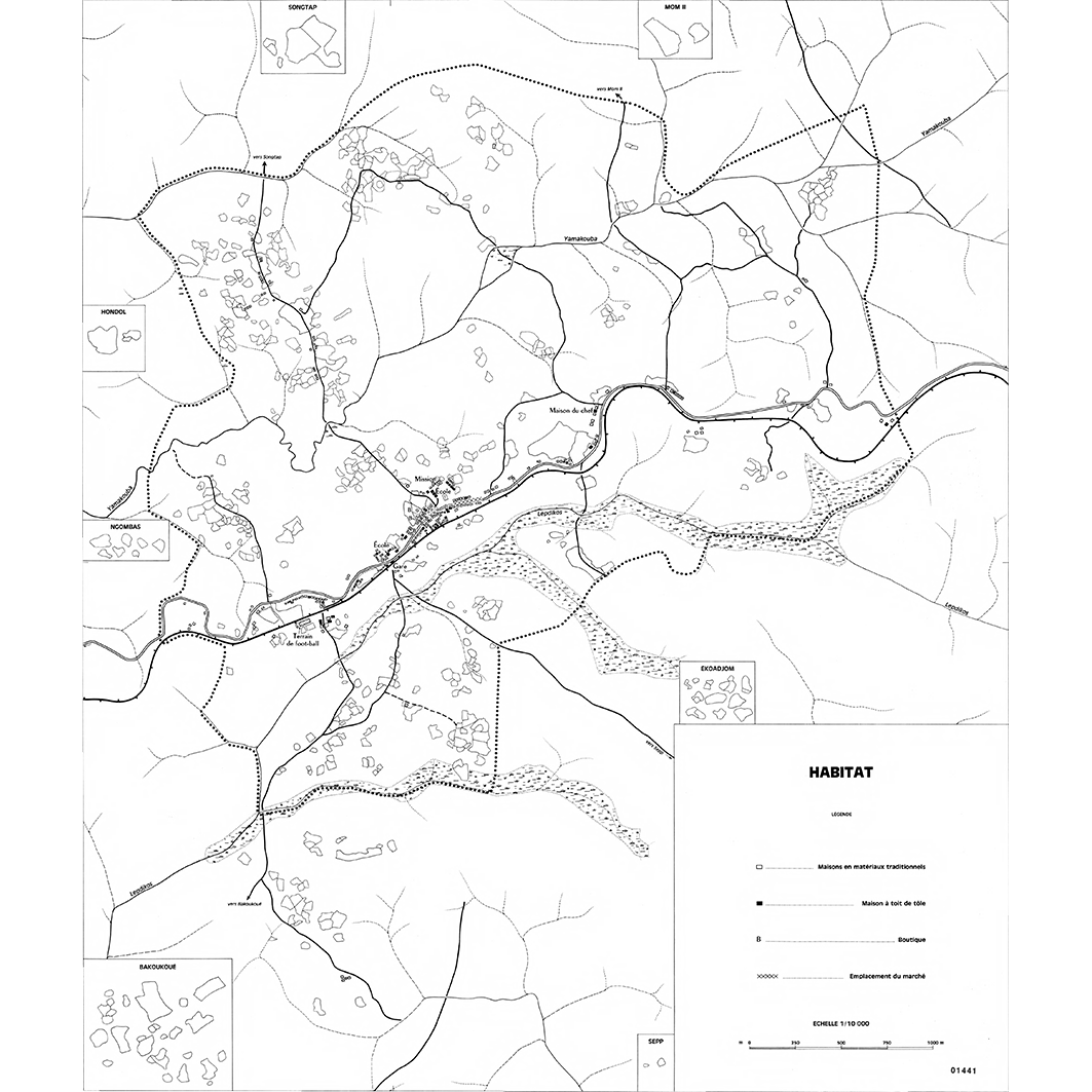
2. Mom : habitat : carte No 2. / Champaud, Jacques; Amouzouvi, J. (ill.); Scale of 1:10 000. Date of publication: 1972. (file: 01441RC_IRD_CMR_INHA_1972_10000_IRD_CMR_CSRE_1972_20000-10000.tif)
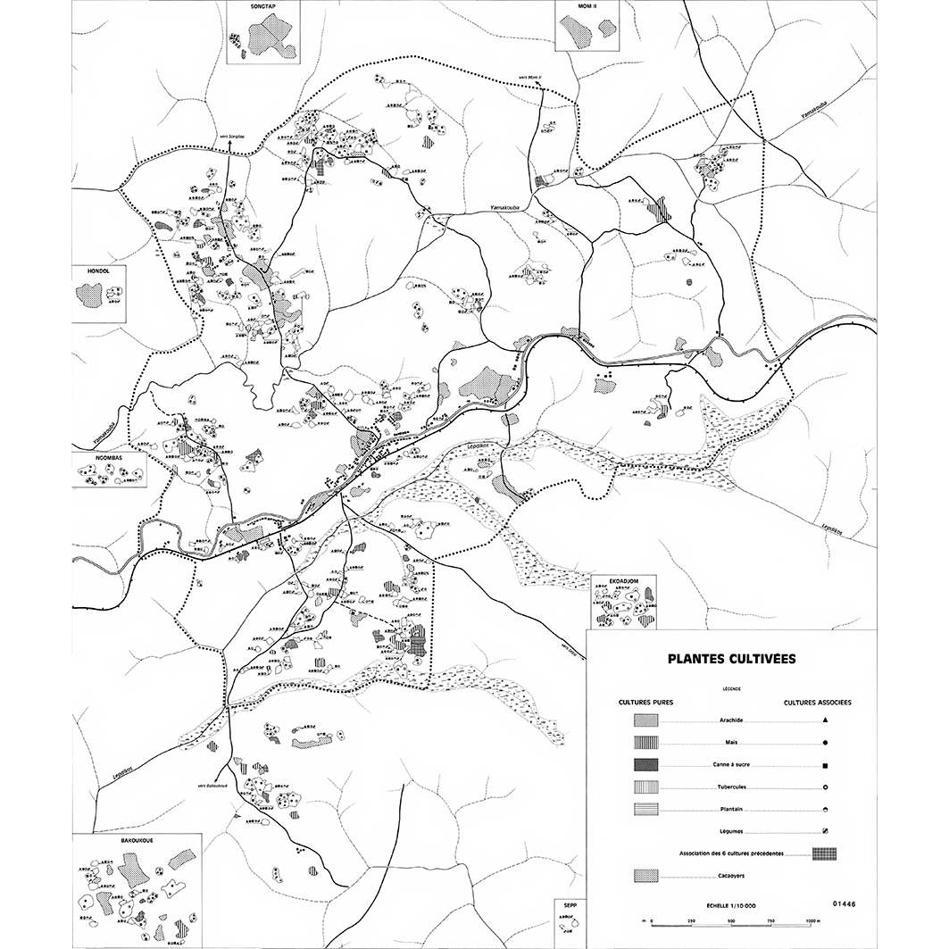
3. Mom : plantes cultivées : carte No 7. / Champaud, Jacques; Amouzouvi, J. (ill.); Scale of 1:10 000. Date of publication: 1972. (file: 01446RC_IRD_CMR_AGCU_1972_10000_IRD_CMR_CSRE_1972_20000-10000.tif)
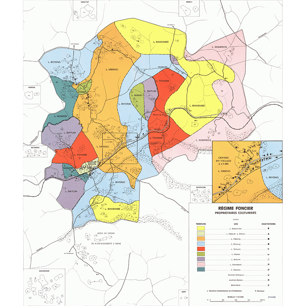
4. Mom : régime foncier : propriétaires coutumiers : carte No 4. / Champaud, Jacques; Amouzouvi, J. (ill.); Scale of 1:10 000. Date of publication: 1972. (file: 01443RC_IRD_CMR_AGFN_1972_10000_IRD_CMR_CSRE_1972_20000-10000.tif)
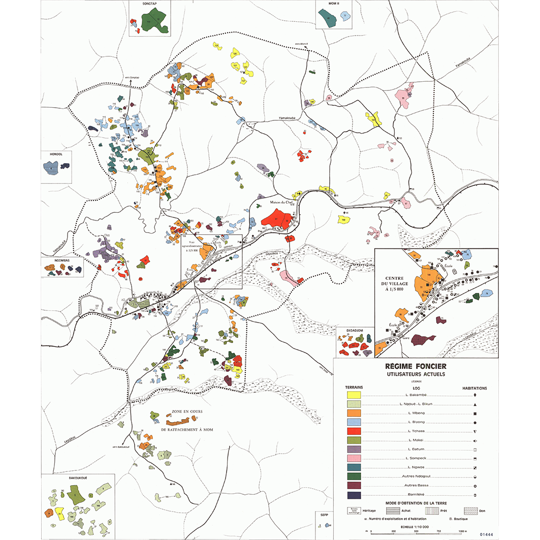
5. Mom : régime foncier : utilisateurs actuels : carte No 5. / Champaud, Jacques; Amouzouvi, J. (ill.); Scale of 1:10 000. Date of publication: 1972. (file: 01444RC_IRD_CMR_AGFN_1972_10000_IRD_CMR_CSRE_1972_20000-10000.tif)
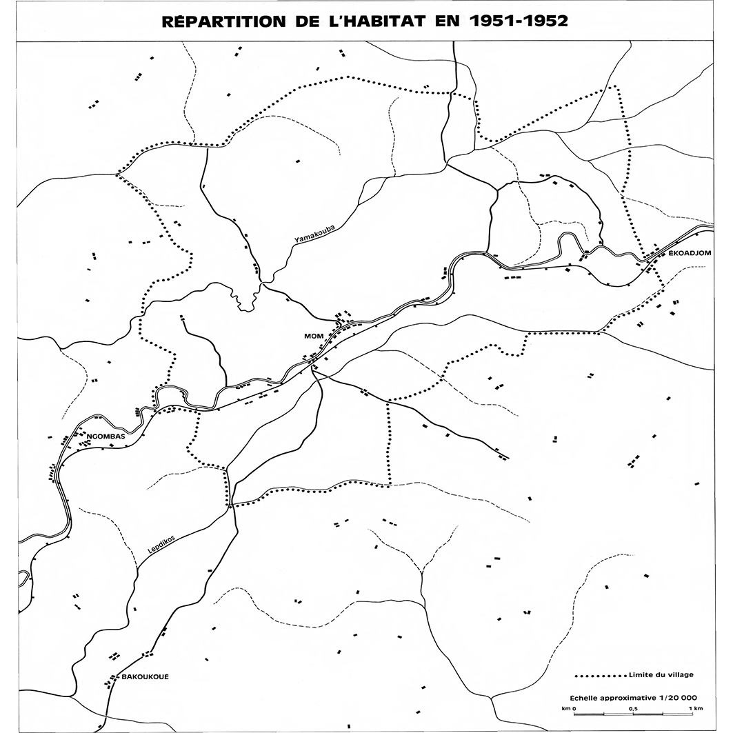
6. Mom : répartition de l'habitat en 1951 - 1952 : carte No 3. / Champaud, Jacques; Scale of 1:20 000. Date of publication: 1972. (file: 01442RC_IRD_CMR_INHA_1972_20000_IRD_CMR_CSRE_1972_20000-10000.tif)
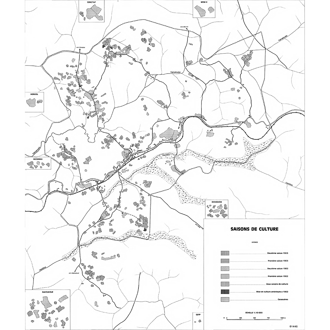
7. Mom : saisons de culture : carte No 6. / Champaud, Jacques; Amouzouvi, J. (ill.); Scale of 1:10 000. Date of publication: 1972. (file: 01445RC_IRD_CMR_AGCU_1972_10000_IRD_CMR_CSRE_1972_20000-10000.tif)
Simple
- Date (Publication)
- 1972-01-01
- Citation identifier
- IRD_CMR_CSRE_1972_20000-10000
- Credit
-
The region Île-de-France, under the project NumeriSud, supported the action to transforme around 2800 maps that are conserved at the Institut de recherche pour le développement (IRD) library in Bondy into a standard coordinate system. The transformation of the images has been done by Global Mapping Resources (South Africa) under the supervision of R. Zaiss (éditeur) 2014.
- Status
- Completed
- Point of contact
-
Organisation name Individual name Electronic mail address Role Institut de recherche pour le développement (IRD)
Production cartographique IRD
Point of contact Champaud, Jacques
Author Amouzouvi, J. (ill.)
Author ORSTOM, Office de la recherche scientifique et technique outre-mer, Service cartographique
editor
- Maintenance and update frequency
- Not planned
-
Geounits
-
-
Africa
-
Middle Africa
-
Cameroon
-
- Theme
-
-
cultural aptitudes, actual productivity
-
thematic map
-
- Keywords
-
-
project NumeriSud
-
map collection
-
local coverage
-
- Use limitation
-
Licence : CC-BY-NC-SA
- Access constraints
- licence
- Classification
- Unclassified
- Spatial representation type
- Grid
- Denominator
- 10000
- Language
- Français
- Character set
- UTF8
- Topic category
-
- Farming
- Geoscientific information
- Planning cadastre
- Society
))
- Begin date
- 1972-01-01
- End date
- 1972-12-31
- Supplemental Information
-
Publication(s):
Champaud, J. (1972): Mom : Terroir bassa (Cameroun). Paris (FRA) : ORSTOM, Office de la recherche scientifique et technique outre mer, Service cartographique.
- Reference system identifier
- EPSG / 4326 / 7.9
- Distribution format
-
Name Version GeoTIFF
1.0
- Distributor contact
-
Organisation name Individual name Electronic mail address Role DataSuds-geo
Publisher
- OnLine resource
-
Protocol Linkage Name OGC:WMS
https://datasuds-geo.ird.fr/geoserver/wms sphaera_ws:01440RC_IRD_CMR_AGPA_1972_10000_IRD_CMR_CSRE_1972_20000-10000
WWW:DOWNLOAD:GeoTIFF https://datasuds-geo.ird.fr/geoserver/ows?service=WCS&version=2.0.1&request=GetCoverage&coverageId=01440RC_IRD_CMR_AGPA_1972_10000_IRD_CMR_CSRE_1972_20000-10000 WWW:LINK-1.0-http--related
https://www.documentation.ird.fr/hor/fdi:02580 Notice explicative ou autre ouvrage
- OnLine resource
-
Protocol Linkage Name OGC:WMS
https://datasuds-geo.ird.fr/geoserver/wms sphaera_ws:01441RC_IRD_CMR_INHA_1972_10000_IRD_CMR_CSRE_1972_20000-10000
WWW:DOWNLOAD:GeoTIFF https://datasuds-geo.ird.fr/geoserver/ows?service=WCS&version=2.0.1&request=GetCoverage&coverageId=01441RC_IRD_CMR_INHA_1972_10000_IRD_CMR_CSRE_1972_20000-10000 WWW:LINK-1.0-http--related
https://www.documentation.ird.fr/hor/fdi:02580 Notice explicative ou autre ouvrage
- OnLine resource
-
Protocol Linkage Name OGC:WMS
https://datasuds-geo.ird.fr/geoserver/wms sphaera_ws:01446RC_IRD_CMR_AGCU_1972_10000_IRD_CMR_CSRE_1972_20000-10000
WWW:DOWNLOAD:GeoTIFF https://datasuds-geo.ird.fr/geoserver/ows?service=WCS&version=2.0.1&request=GetCoverage&coverageId=01446RC_IRD_CMR_AGCU_1972_10000_IRD_CMR_CSRE_1972_20000-10000 WWW:LINK-1.0-http--related
https://www.documentation.ird.fr/hor/fdi:02580 Notice explicative ou autre ouvrage
- OnLine resource
-
Protocol Linkage Name OGC:WMS
https://datasuds-geo.ird.fr/geoserver/wms sphaera_ws:01443RC_IRD_CMR_AGFN_1972_10000_IRD_CMR_CSRE_1972_20000-10000
WWW:DOWNLOAD:GeoTIFF https://datasuds-geo.ird.fr/geoserver/ows?service=WCS&version=2.0.1&request=GetCoverage&coverageId=01443RC_IRD_CMR_AGFN_1972_10000_IRD_CMR_CSRE_1972_20000-10000 WWW:LINK-1.0-http--related
https://www.documentation.ird.fr/hor/fdi:02580 Notice explicative ou autre ouvrage
- OnLine resource
-
Protocol Linkage Name OGC:WMS
https://datasuds-geo.ird.fr/geoserver/wms sphaera_ws:01444RC_IRD_CMR_AGFN_1972_10000_IRD_CMR_CSRE_1972_20000-10000
WWW:DOWNLOAD:GeoTIFF https://datasuds-geo.ird.fr/geoserver/ows?service=WCS&version=2.0.1&request=GetCoverage&coverageId=01444RC_IRD_CMR_AGFN_1972_10000_IRD_CMR_CSRE_1972_20000-10000 WWW:LINK-1.0-http--related
https://www.documentation.ird.fr/hor/fdi:02580 Notice explicative ou autre ouvrage
- OnLine resource
-
Protocol Linkage Name OGC:WMS
https://datasuds-geo.ird.fr/geoserver/wms sphaera_ws:01442RC_IRD_CMR_INHA_1972_20000_IRD_CMR_CSRE_1972_20000-10000
WWW:DOWNLOAD:GeoTIFF https://datasuds-geo.ird.fr/geoserver/ows?service=WCS&version=2.0.1&request=GetCoverage&coverageId=01442RC_IRD_CMR_INHA_1972_20000_IRD_CMR_CSRE_1972_20000-10000 WWW:LINK-1.0-http--related
https://www.documentation.ird.fr/hor/fdi:02580 Notice explicative ou autre ouvrage
- OnLine resource
-
Protocol Linkage Name OGC:WMS
https://datasuds-geo.ird.fr/geoserver/wms sphaera_ws:01445RC_IRD_CMR_AGCU_1972_10000_IRD_CMR_CSRE_1972_20000-10000
WWW:DOWNLOAD:GeoTIFF https://datasuds-geo.ird.fr/geoserver/ows?service=WCS&version=2.0.1&request=GetCoverage&coverageId=01445RC_IRD_CMR_AGCU_1972_10000_IRD_CMR_CSRE_1972_20000-10000 WWW:LINK-1.0-http--related
https://www.documentation.ird.fr/hor/fdi:02580 Notice explicative ou autre ouvrage
- OnLine resource
-
Protocol Linkage Name DOI
https://doi.org/10.23708/2b0e6952-4974-4443-bfa4-028d2b6f6da0 Digital Object Identifier (DOI)
- Hierarchy level
- Dataset
- Statement
-
1. Scanning to tif format, 256 colors, 250dpi.
2. Georeferencing and if possible reprojection to WGS84 (Longitude / Latitude).
3. Clipping and mosaicing of map sheets(s).
4. Export ECW format.
5. ECW to GeoTIFF format conversion.
Metadata
- File identifier
- 2b0e6952-4974-4443-bfa4-028d2b6f6da0 XML
- Metadata language
- English
- Character set
- UTF8
- Hierarchy level
- Dataset
- Hierarchy level name
-
dataset
- Date stamp
- 2024-02-13T18:36:39.542512Z
- Metadata standard name
-
ISO 19115:2003/19139
- Metadata standard version
-
1.0
- Metadata author
-
Organisation name Individual name Electronic mail address Role Institut de recherche pour le développement (IRD)
Service de l'Information Scientifique et Technique (IST) IRD
Point of contact Institut de recherche pour le développement (IRD)
IRD
Resource provider
Overviews
Spatial extent
Provided by
