 Demo Catalogue powered by geOrchestra
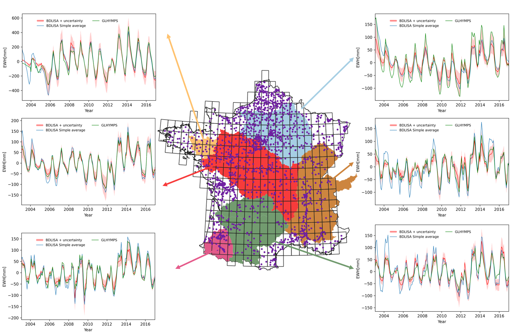
A dataset of well-based regional groundwater storage variations in France
Groundwater comprises approximately 30 percent of the Earth’s total freshwater, serving as a vital resource for both humans and ecosystems. As an essential source of drinking water for humans and sustenance for vegetation, groundwater plays a key role in the terrestrial water cycle. It acts as a buffer, enabling adaptation to climate variability and extreme events like floods and droughts. Therefore, understanding groundwater storage is important for both ecological and15 societal reasons.
Simple
- Date (Creation)
- 2023-07-12T10:30:00
- Date (Publication)
- 2023
- Citation identifier
- https://www.osuris.fr/geonetwork/srv/metadata/8425dbe1-5e4a-409f-a504-e1c891938680
- Presentation form
- Digital map
- Purpose
-
The reasons of this dataset are
- essential for humans and ecosystems
- allows adaptation to climate variability
- a few words on 2022 drought
- how this data set can be used
- Status
- Under development
- Point of contact
-
Organisation name Individual name Electronic mail address Role HafenCity Universtiy Hamburg
Kuei-Hua Hsu
Point of contact HafenCity Universtiy Hamburg
Annette Eicker
Author Géosciences Rennes UMR6118 CNRS Université de Rennes1
Laurent Longuevergne
Author GeoforschungsZentrum Potsdam
Andreas Güntner
Author
- Maintenance and update frequency
- As needed
- Theme
-
-
storage
-
well
-
specific yield
-
-
GEMET - INSPIRE themes, version 1.0
-
-
Hydrography
-
-
GEMET
-
-
groundwater
-
hydrogeology
-
water resource
-
-
Continents, countries, sea regions of the world.
-
-
France
-
- Use limitation
-
Utilisation libre sous réserve de mentionner la source (a minima le nom du producteur) et la date de sa dernière mise à jour
- Access constraints
- License
- Use constraints
- License
- Spatial representation type
- Vector
- Denominator
- 5000
- Language
- English
- Character set
- UTF8
- Topic category
-
- Geoscientific information
- Environment
- Inland waters
- Location
- Begin date
- 2003-01-01T00:00:00
- End date
- 2016-01-01T00:00:00
))
- Reference system identifier
- WGS 1984
- Distribution format
-
Name Version CSV
1.0
- Distributor contact
-
Organisation name Individual name Electronic mail address Role copernicus
- Distributor contact
-
Organisation name Individual name Electronic mail address Role OSUR
Publisher
- OnLine resource
-
Protocol Linkage Name WWW:LINK-1.0-http--link
http://geosciences.univ-rennes1.fr
- OnLine resource
-
Protocol Linkage Name DOI
https://doi.org/10.26169/11f914d3-6bc4-4d03-afdb-25c5a28af4b5 Digital Object Identifier (DOI)
- Hierarchy level
- Dataset
Conformance result
- Title
-
COMMISSION REGULATION (EU) No 1089/2010 of 23 November 2010 implementing Directive 2007/2/EC of the European Parliament and of the Council as regards interoperability of spatial data sets and services
- Date (Publication)
- 2023-07-30T00:00:00
- Pass
- Yes
- Statement
-
Décrire le protocole d'acquisition
Metadata
- File identifier
- 11f914d3-6bc4-4d03-afdb-25c5a28af4b5 XML
- Metadata language
- English
- Character set
- UTF8
- Hierarchy level
- Dataset
- Date stamp
- 2023-07-20T15:55:00
- Metadata standard name
-
ISO 19115:2003/19139
- Metadata standard version
-
1.0
- Metadata author
-
Organisation name Individual name Electronic mail address Role Osur CNRS Université de Rennes
Osuris
Point of contact Géosciences Rennes UMR6118 CNRS Université de Rennes1
Laurent Longuevergne
Author
)))
